INTRODUCTION
 The aim of this paper is to illustrate the majority of hard-shelled modern benthic foraminifera encountered on the Hebridean shelf west of Oban, Scotland, and to provide some notes on its mode of life. It complements separate studies which discuss the ecology and development of the dead assemblages
(Murray 1985, in
press). This paper brings together data from the open outer shelf and from shelf depressions known as
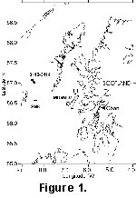
'deeps'. The latter have muddy sand substrates: Muck Deep (maximum depth 230 m) on the inner shelf and Stanton Deep (maximum depth 167 m) on the outer shelf
(Murray, in press)
(Figure 1). The samples from the higher energy shelf exposed to the influence of storm waves have previously been discussed by
Murray (1985) and are from sandy substrates. As live and dead forms have been treated separately, it is possible to specify which taxa are infaunal and which are epifaunal, either on the sediment surface or, more commonly, attached to firm substrates such as shells, hydroids, etc.
The aim of this paper is to illustrate the majority of hard-shelled modern benthic foraminifera encountered on the Hebridean shelf west of Oban, Scotland, and to provide some notes on its mode of life. It complements separate studies which discuss the ecology and development of the dead assemblages
(Murray 1985, in
press). This paper brings together data from the open outer shelf and from shelf depressions known as
'deeps'. The latter have muddy sand substrates: Muck Deep (maximum depth 230 m) on the inner shelf and Stanton Deep (maximum depth 167 m) on the outer shelf
(Murray, in press)
(Figure 1). The samples from the higher energy shelf exposed to the influence of storm waves have previously been discussed by
Murray (1985) and are from sandy substrates. As live and dead forms have been treated separately, it is possible to specify which taxa are infaunal and which are epifaunal, either on the sediment surface or, more commonly, attached to firm substrates such as shells, hydroids, etc.
The first major work on the modern foraminifera of Britain was that of Williamson (1858) in which he illustrated and named taxa from a wide range of localities, some of which were from the west coast of Scotland - Arran, Skye, Loch Fyne. Later major works on the taxonomy of foraminifera from the UK continental shelf include
Murray (1971, revised
2000), and
Haynes
(1973). Distributional/ecological studies include various inner shelf-localities
(Heron-Allen and Earland
1916), North Minch Channel (Edwards
1982), open shelf and deeps (Murray 1985,
in press; Murray and Whittaker
2001), and Clyde Sea (Hannah and Rogerson
1997). Only Murray and Hannah and Rogerson have distinguished live (stained) from dead.
The Shelf Environment:
The summer mean bottom salinites are 35.25 and 34.5-35.0 psu for the outer shelf (Stanton Deep area and open shelf samples) and inner shelf (Muck Deep area) respectively, and a mean summer bottom temperature of ~10°C. According to
Elliott et al. (1991) the January bottom water temperature is around 8°C on the outer shelf and around 7.5°C on the inner shelf; whereas during the summer months the waters are stratified over the outer shelf, and they are vertically mixed throughout the year over the inner shelf. Both outer and inner shelf have a maximum surface tidal current speed of 1-2 knots (51-102 cm s-1) at spring tides
(Lee and Ramster
1981) but there are no published bottom current measurements. From a mathematical analysis of tides,
Pingree and Griffiths (1979) concluded that the interaction of the M2 (principal lunar semi-diurnal constituent) and M4 (shallow water, quarter diurnal harmonic) tides is the main cause of the direction of sediment transport. Wave measurements on an adjacent area of shelf (South Uist,
Stanton,
1984) show that the 50 year significant wave height is around 12-13 m. Over a seven year period of observations, wave height/periodicity varied from <1 m/3 secs to 11 m/12 secs. The increasing wave heights recorded in this area during the latter part of the twentieth century is coincident with the long-term rise in the North Atlantic Oscillation
(Woolf, et al., in
press). In order to mobilise bottom sediment on the shelf at a water depth of 80 m, a minimum wave height of 10 m is required. This may be very rarely be achieved (Woolf, pers. comm., 2002). Thus, it appears that the shelf in general is subject to disturbance from tidal currents and also intermittently from storm waves. The deeps are lower energy depositional areas.
The open shelf sediments are rich in biogenic carbonate (Wilson 1979,
1982) because no major rivers flow into the area so there is low input of terrigenous detritus. Sand patches with a rippled surface and locally very variable composition
(Belderson et al. 1971, figure 8) rest on a basal transgressive conglomerate. Published radiocarbon dates based on bulk surface sediment samples gave ages of 3772 and for a glauconite-infilled bryozoan 870 years
(Stride et al.
1999). Thus the shelf sediments are a mix of contemporary and older material (from lower sea level and Holocene transgression) and probably accumulated rather slowly. During the Plio-Pleistocene glacial events, elongate basins were eroded across the shelf. They were subsequently wholly or partially infilled with sediments (>200 m Quaternary deposits,
Fyfe et al.
1993). The incompletely filled examples now form the 'deeps'. In muddy areas, there is no clear separation between the modern sediments and the underlying late to postglacial clays. The surface sediments in the deeps have a variable clay content
(Table 1).