THE
YANGBI RIVER EXPEDITION, 1994
After the crisis at Tienanmen Square, it took us
five years to regain momentum. We were unable to find corporate support, so we
weren’t able to afford permits for the main stream of the Mekong. The Chinese
offered us a discount to run the
Yangbi River, a large tributary to the Mekong
just east of the stretch we had originally planned to explore. By
1994, there were only seven of us who were still interested in the expedition:
Will, Peter Molnar, his wife Sara Neustadtl, Mike Connelly, Ben Foster, Ralf
Buckley, and I. By then, Will was traveling so often that he had lots of
frequent flyer miles, he had already translated dozens of Chinese
paleontological articles into English, and he had published his first article
based on field research in China (Tedford et al. 1991). Will graciously gave
Sara a free airline ticket so that she could join us, and during the expedition,
he developed a lasting relationship with Peter that ultimately led to a
coauthored article (Zhang et al. 2001).
With such a small research group and limited time,
we decided that it was only feasible to field check a Chinese geological map of
the area that Will had obtained for us. It had been compiled from aerial photos
with a few field checks where there was road access. Considering the 1:500,000
scale, we found it to be reasonably accurate.
 On the way to the river, we stayed in Xiaguan, an
industrial town not far from Dali, the ancient capital of the area. From
Xiaguan, the road follows the river that drains Er Hai (Ear Lake) west down a
steep canyon through amphibolite-grade Paleozoic rocks with a northwest near
vertical foliation and a near horizontal lineament – probably the northwest
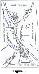
extension of the Ailiao Shan shear zone (Figure 7).
Tapponier et al. (1990)
hypothesized that about 500 km of left-lateral strike-slip displacement occurred
along this shear zone. Further southeast, the younger and more clearly defined
right lateral Red River Fault follows this lineament (Allen et al. 1984;
Figure
8). Both faults appear to be related to India’s collision with Asia. As the
“horn” of the Indian subcontinent (the east Himalayan syntax) passed the
extruded Indochina block, displacement changed from left lateral to right
lateral (Huchon et. al. 1994).
On the way to the river, we stayed in Xiaguan, an
industrial town not far from Dali, the ancient capital of the area. From
Xiaguan, the road follows the river that drains Er Hai (Ear Lake) west down a
steep canyon through amphibolite-grade Paleozoic rocks with a northwest near
vertical foliation and a near horizontal lineament – probably the northwest
extension of the Ailiao Shan shear zone (Figure 7).
Tapponier et al. (1990)
hypothesized that about 500 km of left-lateral strike-slip displacement occurred
along this shear zone. Further southeast, the younger and more clearly defined
right lateral Red River Fault follows this lineament (Allen et al. 1984;
Figure
8). Both faults appear to be related to India’s collision with Asia. As the
“horn” of the Indian subcontinent (the east Himalayan syntax) passed the
extruded Indochina block, displacement changed from left lateral to right
lateral (Huchon et. al. 1994).
We rafted and kayaked about 120 km of the Yangbi
in eight days, then took another two days to cross the recently created 100 km
Man Wan Reservoir. For the first two days, the river flowed in a narrow,
challenging canyon composed of Mesozoic slates that were being mined for roof
shingles. For the next four days, we floated through a wide, deep valley in
Mesozoic red sandstones, with no rapids and few rock exposures. Halfway through
this stretch, the river turned sharply to the east. Will was fascinated by
frequent exposures of what appeared to be poorly consolidated Quaternary
sandstone in large “patches,” often extending one or two hundred meters up steep
valleys, suggestive of a much drier, windier climate subsequent to development
of the river canyon. He had studied late Quaternary deposits that had been
useful in placing constraints on the age of the Grand Canyon as a topographic
feature and thought that these sandstones might provide some constraints on the
age of the Yangbi drainage.
 On the seventh day, the river turned due south,
and we immediately began to encounter challenging rapids. We camped that night
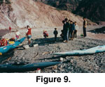
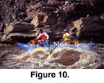
across from an unmapped 30 m wide fault zone in Mesozoic redbeds (Figure 9). A
huge mudslide beginning at the head of a side canyon following the fault had
occurred two weeks earlier, destroying houses and crops and forcing the river
into a narrow rock-filled channel with numerous rapids (Figure 10). Like most
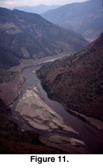
Himalayan rivers, the Yangbi can move a lot of sediment in flood (Figure 11).
On the seventh day, the river turned due south,
and we immediately began to encounter challenging rapids. We camped that night
across from an unmapped 30 m wide fault zone in Mesozoic redbeds (Figure 9). A
huge mudslide beginning at the head of a side canyon following the fault had
occurred two weeks earlier, destroying houses and crops and forcing the river
into a narrow rock-filled channel with numerous rapids (Figure 10). Like most
Himalayan rivers, the Yangbi can move a lot of sediment in flood (Figure 11).
 Above river level, the canyon slopes were often so
heavily vegetated that faults were poorly exposed, and we had little opportunity
to search for mylonites. Contacts between the high grade Paleozoic metamorphic
and intrusive rocks and the overlying Mesozoic low grade metasediments obviously
were not fault contacts as suggested by the Chinese map; rather, the transition
from high grade to low grade suggested two metamorphic events. (1) High grade
metamorphism in the Paleozoic rocks that most likely predated deposition of the
Mesozoic rocks (above a nonconformable contact), and (2) low grade metamorphism
in the Mesozoic rocks, such as the slates we had encountered on the first two
days, that could have been produced by deformation resulting from India’s
Cenozoic collision with Asia.
Above river level, the canyon slopes were often so
heavily vegetated that faults were poorly exposed, and we had little opportunity
to search for mylonites. Contacts between the high grade Paleozoic metamorphic
and intrusive rocks and the overlying Mesozoic low grade metasediments obviously
were not fault contacts as suggested by the Chinese map; rather, the transition
from high grade to low grade suggested two metamorphic events. (1) High grade
metamorphism in the Paleozoic rocks that most likely predated deposition of the
Mesozoic rocks (above a nonconformable contact), and (2) low grade metamorphism
in the Mesozoic rocks, such as the slates we had encountered on the first two
days, that could have been produced by deformation resulting from India’s
Cenozoic collision with Asia.
 Two nights later, we camped at the confluence of
the Yangbi and Mekong. Overnight, the Mekong rose yet its velocity decreased, a
sure sign that we were on a reservoir. The Man Wan Dam, located about 100 km
downstream, had been completed in 1993. The Man Wan Dam is the first of seven
that the Chinese plan to complete on the Mekong in Yunnan by 2018. The
cumulative hydropower will be equivalent to all of the major dams managed by the
US Bureau of Reclamation in the western United States – about 15 gigawatts. The
river-scoured exposures of the Nanding Fault that we had planned to examine on
the 1989 expedition were inundated by the new reservoir.
Two nights later, we camped at the confluence of
the Yangbi and Mekong. Overnight, the Mekong rose yet its velocity decreased, a
sure sign that we were on a reservoir. The Man Wan Dam, located about 100 km
downstream, had been completed in 1993. The Man Wan Dam is the first of seven
that the Chinese plan to complete on the Mekong in Yunnan by 2018. The
cumulative hydropower will be equivalent to all of the major dams managed by the
US Bureau of Reclamation in the western United States – about 15 gigawatts. The
river-scoured exposures of the Nanding Fault that we had planned to examine on
the 1989 expedition were inundated by the new reservoir.
Although it was evident from the Yangbi expedition
that further research on the structural relationships among unmetamorphosed
Cenozoic, low grade metamorphic Mesozoic and high grade metamorphic pre-Mesozoic
rocks was warranted, we were never able to motivate a group of geoscientists to
pursue research in this area. The Chinese government was rapidly opening Tibet
to research by foreigners, and it has received most of the emphasis of tectonic
research over the past decade.
