| |
SETTING AND SITE DESCRIPTION
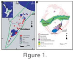 The Rotokawa geothermal field is situated in the southeastern margin of the Taupo Volcanic Zone, North Island, New Zealand (Figure 1.1). The field covers an area of ~6 km2 that is characterised by steaming ground, fumaroles, hot springs, mud pots, collapse pits, and infilled hydrothermal eruption craters (Figure 1.2) (Browne 1974; Krupp et al. 1986; Krupp and Seward 1987). Holocene pumice of the Taupo Subgroup and hydrothermal eruption breccia cover much of the surface of the thermal area (Healy 1965; Vucetich and Pullar 1973; Collar and Browne 1985). Hot springs discharge predominantly acid-sulphate-chloride waters (pH of 2-4) (Ellis and Wilson 1961; Jones et al. 2000; Teece 2000; Mountain et al. 2003). The most prominent surface features are the acidic (pH ~2.3) Lake Rotokawa of 0.6 km2 and the main thermal area directly to the north (Forsyth 1977; Krupp et al. 1986; Krupp and Seward 1987). On the northeastern margin of Lake Rotokawa, hot spring activity occurs in a terrace called "Sinter Flat" (Krupp et al. 1986; Krupp and Seward 1987). Several thin siliceous deposits and stromatolitic growth features have been described from this terrace (e.g., Krupp et al. 1986; Krupp and Seward 1987; Jones et al. 2000; Teece 2000; Mountain et al. 2003). The Rotokawa geothermal field is situated in the southeastern margin of the Taupo Volcanic Zone, North Island, New Zealand (Figure 1.1). The field covers an area of ~6 km2 that is characterised by steaming ground, fumaroles, hot springs, mud pots, collapse pits, and infilled hydrothermal eruption craters (Figure 1.2) (Browne 1974; Krupp et al. 1986; Krupp and Seward 1987). Holocene pumice of the Taupo Subgroup and hydrothermal eruption breccia cover much of the surface of the thermal area (Healy 1965; Vucetich and Pullar 1973; Collar and Browne 1985). Hot springs discharge predominantly acid-sulphate-chloride waters (pH of 2-4) (Ellis and Wilson 1961; Jones et al. 2000; Teece 2000; Mountain et al. 2003). The most prominent surface features are the acidic (pH ~2.3) Lake Rotokawa of 0.6 km2 and the main thermal area directly to the north (Forsyth 1977; Krupp et al. 1986; Krupp and Seward 1987). On the northeastern margin of Lake Rotokawa, hot spring activity occurs in a terrace called "Sinter Flat" (Krupp et al. 1986; Krupp and Seward 1987). Several thin siliceous deposits and stromatolitic growth features have been described from this terrace (e.g., Krupp et al. 1986; Krupp and Seward 1987; Jones et al. 2000; Teece 2000; Mountain et al. 2003).
 Lake Rotokawa drains via Parariki Stream in a northeast direction from the east side of the lake into the Waikato River (Figure 1.2). Numerous hot springs situated on the stream banks discharge silica-rich, acid-sulphate-chloride waters along the southern part of the stream (Grange 1937; Forsyth 1977; Krupp and Seward 1987; Teece 2000). Lake Rotokawa drains via Parariki Stream in a northeast direction from the east side of the lake into the Waikato River (Figure 1.2). Numerous hot springs situated on the stream banks discharge silica-rich, acid-sulphate-chloride waters along the southern part of the stream (Grange 1937; Forsyth 1977; Krupp and Seward 1987; Teece 2000).
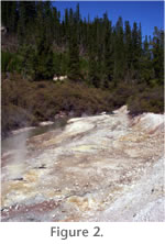
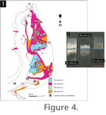
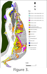 The study site is situated on a pumiceous floodplain (Figure 2), located primarily alongside the western bank of the Parariki Stream, ~1 km northeast of Lake Rotokawa (Figure 1.2, red arrow). This floodplain is ~30 m long, up to 7 m wide and separated from the stream by a series of riffles, composed of well sorted coarse pumiceous alluvium (Figure 3). Through most of the year in 2004, the stream was confined to its channel and did not infiltrate the floodplain. During summer, thermal water levels were often lower than during winter. Hot spring vents at this site discharge mostly clear acid-sulphate-chloride waters (Table 1) ranging from 91 to 40°C with an average pH of ~2.2 (Figure 4).
Teece (2000) determined that silica in the Parariki discharge waters is predominantly monomeric. The spring water discharging into the Parariki Stream and the study site contain about 300 mg kg-1 SiO2 (Table 1). The study site is situated on a pumiceous floodplain (Figure 2), located primarily alongside the western bank of the Parariki Stream, ~1 km northeast of Lake Rotokawa (Figure 1.2, red arrow). This floodplain is ~30 m long, up to 7 m wide and separated from the stream by a series of riffles, composed of well sorted coarse pumiceous alluvium (Figure 3). Through most of the year in 2004, the stream was confined to its channel and did not infiltrate the floodplain. During summer, thermal water levels were often lower than during winter. Hot spring vents at this site discharge mostly clear acid-sulphate-chloride waters (Table 1) ranging from 91 to 40°C with an average pH of ~2.2 (Figure 4).
Teece (2000) determined that silica in the Parariki discharge waters is predominantly monomeric. The spring water discharging into the Parariki Stream and the study site contain about 300 mg kg-1 SiO2 (Table 1).
 They are thus very close to saturation with respect to amorphous silica but oversaturated in silica with respect to opal-CT, opal-C and quartz (cf. Fournier, 1985; Dove and Rimstidt, 1994). The relatively high silica contents are a legacy of the >320°C equilibration temperatures in the geothermal reservoir (Krupp et al. 1986; Krupp and Seward 1987), with silica derived from depth, rather than being leached from the surface rocks, as is the case in many acid-sulphate areas (cf. White et al. 1956; Rodgers et al. 2002, 2004). For this reason, deposits forming directly from these silica-rich waters are interpreted to be silica sinter, rather than silica residue (Rodgers et al. 2004). They are thus very close to saturation with respect to amorphous silica but oversaturated in silica with respect to opal-CT, opal-C and quartz (cf. Fournier, 1985; Dove and Rimstidt, 1994). The relatively high silica contents are a legacy of the >320°C equilibration temperatures in the geothermal reservoir (Krupp et al. 1986; Krupp and Seward 1987), with silica derived from depth, rather than being leached from the surface rocks, as is the case in many acid-sulphate areas (cf. White et al. 1956; Rodgers et al. 2002, 2004). For this reason, deposits forming directly from these silica-rich waters are interpreted to be silica sinter, rather than silica residue (Rodgers et al. 2004).
At the study site, four main types of siliceous sinter deposits were discerned (Figure 3). They are defined herein as four distinct sedimentary microfacies based on temperature and hydrodynamics of surrounding thermal water, the geometry, size and texture of the sinters, as well as their associated microbiota. |