FIGURE 1. Location and stratigraphy of the Langenberg locality. 1: Paleogeographic map of the Late Jurassic (150 Mya) of Central Europe, showing the five main regions which contain dinosaur tracks: (1) Swiss Jura Mountains; (2) French Jura Mountains; (3) Lot (France); (4) Holy Cross Mountains (Poland); (5) Wiehen Mountains (Germany) as well as the Langenberg tracksite (6), which is described herein. Map reconstruction from Ron Blakey, Colorado Plateau Geosystems, Arizona, USA (cpgeosystems.com/paleomaps.html). 2: Geographical position of the Langenberg Quarry near Goslar. 3: Measured section of a part of the “Mittlerer Kimmeridge”, redrawn from Fischer (1991).
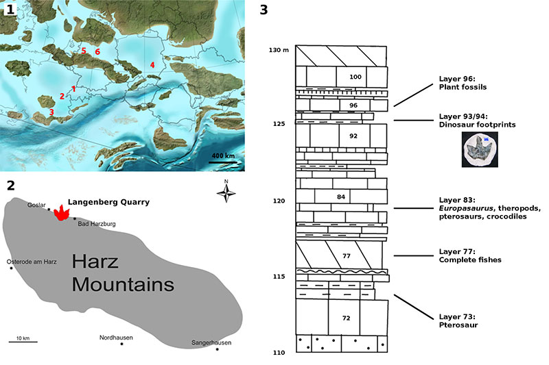
FIGURE 2. The Langenberg tracksite during excavation. Left: Archival photograph by NK (2003). The white box shows the location of the tracksite. Right: Digitally cropped version of the photograph, showing the tracksite (the whitish spot on the right slab represents plaster). See also Figure 9 for depth-color images of the photogrammetric model and Figure 10 for an orthofoto and an interpretative drawing.
FIGURE 3. Schematic outline drawings (based on footprint DFMMh/FV 644 from the Langenberg tracksite) showing basic footprint and trackway parameters, measured lines and angles are highlighted in blue. Gray areas indicate claw marks. 1: Digit divarication, measured in degrees between the digital axes (da) of digit II and III and III and IV. The footprint span (Sp) was measured between the distal ends of the axes of digit impressions II and IV. 2: Footprint length and width. Footprint width was measured at a right angle to the digital axis of digit III. 3: Basic trackway parameters following Marty (2008) (RP: right pes; LP: left pes; S: stride length; WAP: Width of the pes angulation pattern; γ: pace angulation).
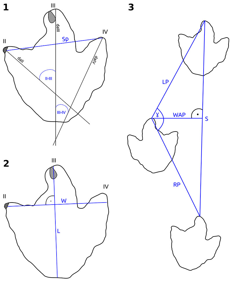
FIGURE 4. Historical photogrammetry based on photographs of limited quality. Footprints 14 and DFMMh/FV 647 are only visible on very few archival photographs and thus do not appear in the photogrammetric model of the whole tracksite. 1-3: The only three detail photographs showing DFMMh/FV 647 in situ. Note that photographs 2 and 3 are nearly identical. Photograph 1 was taken by NK, while photographs 2 and 3 were taken by Holger Lüdtke at the time of excavation in 2003. 4: Photogrammetric model (depth-color image) of DFMMh/FV 647, based only on the three detail photographs (1-3), the minimum number of photographs required by the software to generate a model. This model reveals additional details (most importantly the impression of digit II), which were lost during excavation of the footprint. 5: Detail of the best photograph showing footprint 14 (digitally cropped version of an original archival photograph by NK from 2003). Note the poor resolution and the low angle of the photograph. The approximate position and width of this footprint was determined by placing marker points on the photographs and using the camera alignment performed by Agisoft Photoscan to project these marker points on the 3D model.
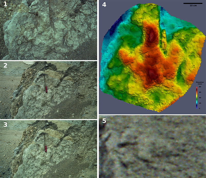
FIGURE 5. Photogrammetric pitfalls: Depth-color image of an incorrect photogrammetric model resulting from an erroneous alignment of the photographs. Arrows indicate artifacts, including crack-like structures running from the left to the right as well as longitudinal structures running down the slab which resemble ripple marks.
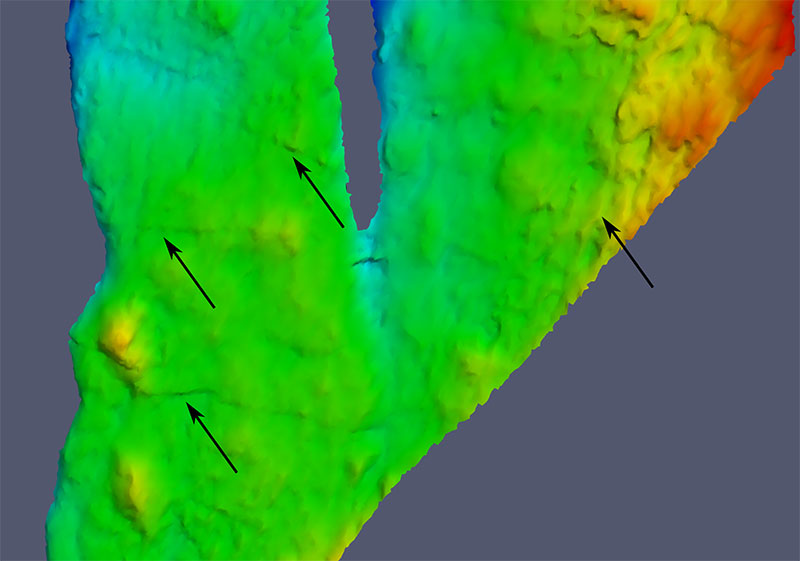
FIGURE 6. Depth-color images (left) and orthophotos (right) of 1: DFMMh/FV 647, 2: DFMMh/FV 646, 3: DFMMh/FV 645 and 4: DFMMh/FV 644. Images to scale.
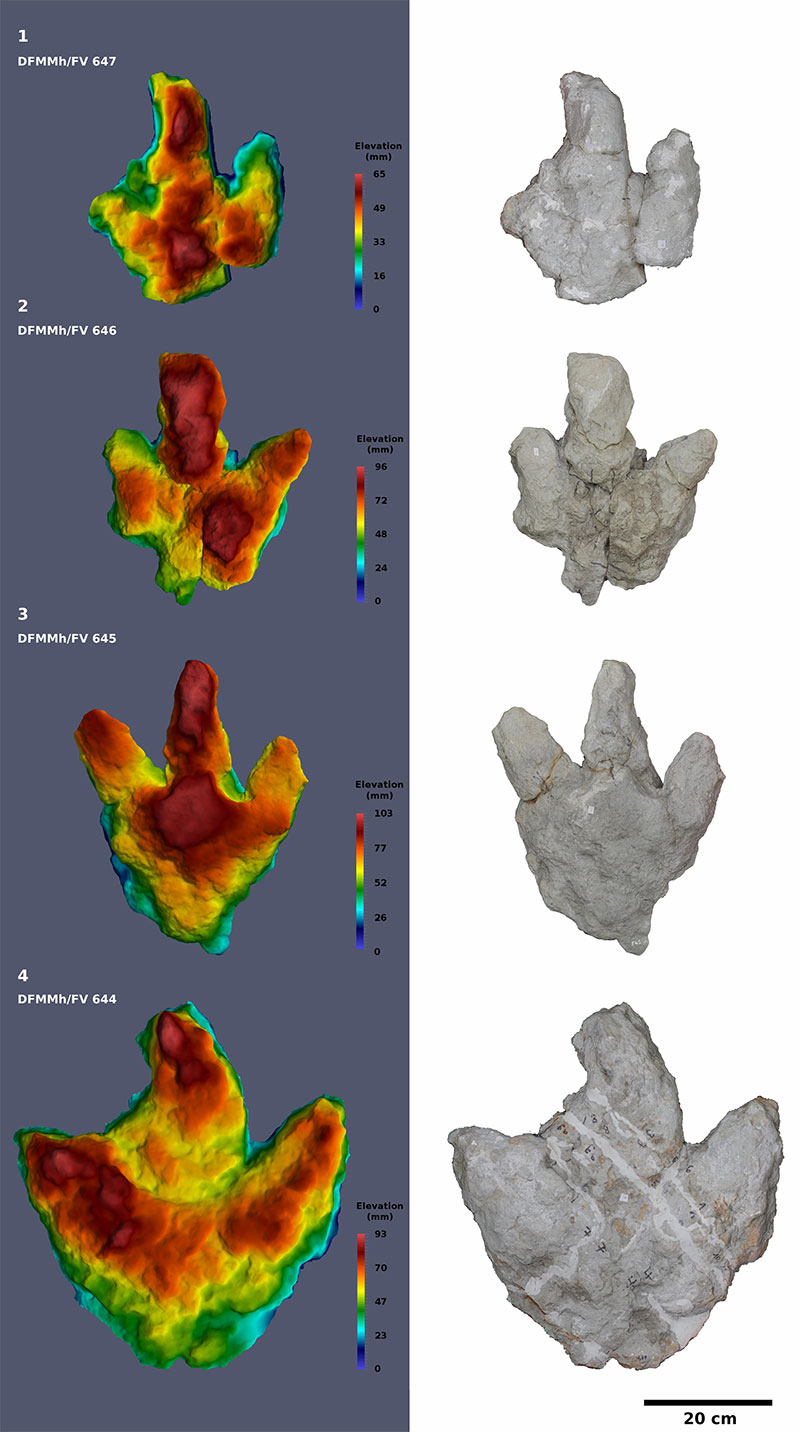
FIGURE 7. Depth-color image (left) and orthophoto (right) of DFMMh/FV 648. Not to scale with Figure 6.
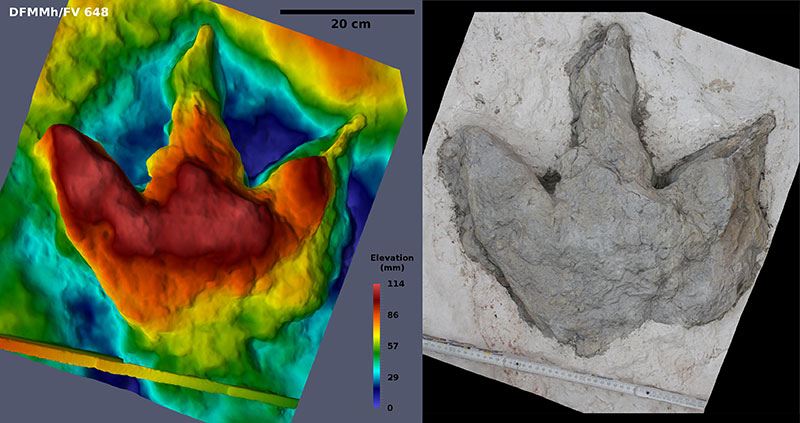
FIGURE 8. Recent photograph of DFMMh/FV 648, the best preserved footprint, photographed at a low angle. The arrow shows the strongly inclined digit impression IV.
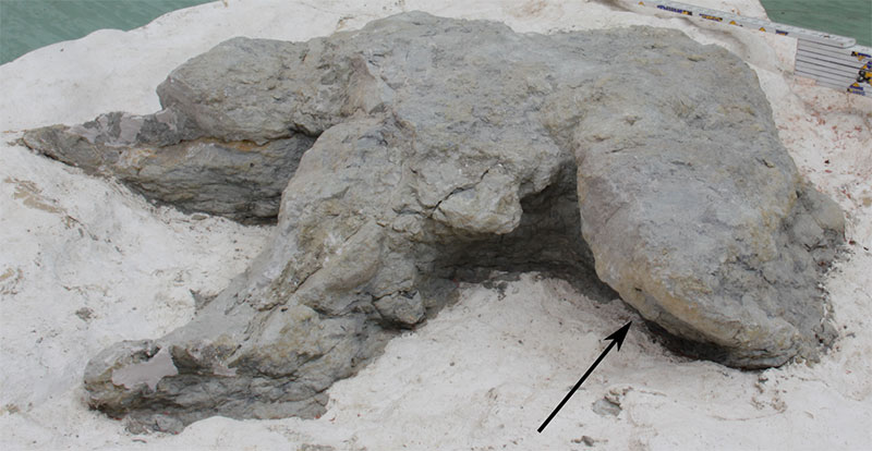
FIGURE 9. The most detailed regions of the historical photogrammetric model, shown as depth-color images. 1: Part of the left slab. Trackway 1 (footprints 6-9) and parts of trackway 2 (footprints 12 and 13) can be seen. The lineaments within trackway 1 and on the right of footprint 644 represent meter sticks incorporated into the photogrammetric model. 2: Part of the right slab. The excavated footprints DFMMh/FV 644 and 646, footprint 23, trackway 3 (footprints 20, 21, and 22) and possible additional footprints (24, 25, 26) can be seen. Compare with Figure 10. Scale bar: 1 m, 1 and 2 are to scale.
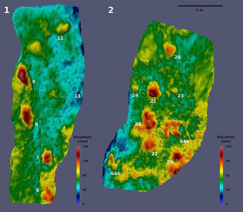
FIGURE 10. Complete historical photogrammetric model of the Langenberg tracksite. Left: Orthophoto; right: sitemap. Confirmed footprints are drawn in red, and elevations that might represent additional tracks are drawn in gray. Note that DFMMh/FV 645 and 648 do not appear on this chart, because the position of these footprints on the tracksite was not documented by photographs. Sitemap and orthophoto to scale.
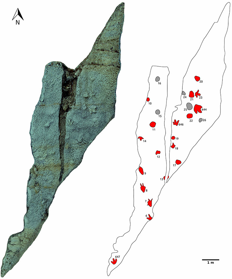
FIGURE 11. The three recognized trackways. The blue lines show the pace, the green lines the stride length. Arrows indicate direction of trackways. Measurements based on the historical photogrammetric model (pace length, stride length, and pace angulation) are included. Scale bars equal 1 m, respectively. Trackways are not to scale.
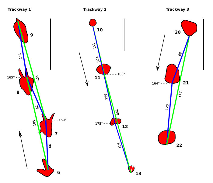
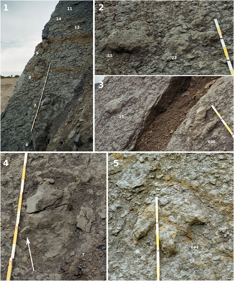
FIGURE 12. Details of the original tracksite. 1: Detail of the left slab, showing trackway 1 (footprints 6, 7, 8, and 9), parts of trackway 2 (footprints 11 and 12), and the isolated footprint 14. Archival photograph by Holger Lüdtke from 2003. 2: Detail of the right slab, showing a deep track (footprint 21) and a better defined track (footprint 22) in close proximity. Digitally cropped version of an archival photograph (NK, 2003). 3: Detail of the tracksite. Footprint 11 shows the morphology typical for the deep tracks of the site. Footprint DFMMh/FV 646 is a well-defined track. Digitally cropped version of archival photograph (Nils Knötschke, 2003). 4: Footprint 7, featuring a hallux impression, as shown by the arrow. Digitally cropped version of archival photograph by NK, 2003. 5: DFMMh/FV 644, as it was in situ prior excavation. Digitally cropped version of archival photograph by NK, 2003.