FIGURE 1. 1. Regional geological setting of the Bengal Delta Complex with reference to down drift coastal plains incorporating large area covered by modern mangrove forest of Sundarbans, the Bay of Bengal Sea and Quaternary stratigraphy with time-successive palaeocoastlines (modified after Mallick et al., 1972). Note position of studied Bakkhali beach sector. 2. Magnified view of coastal beach sectors with location of study area (marked by red) by the side of a mighty estuary and position (*) of reported Uca marionis mud volcanoes (De, 2009). 3. A field excavation site from study area showing occurrence of soft mud layers below relatively dry and rigid sand layers with sharp contact as specific substrate condition.
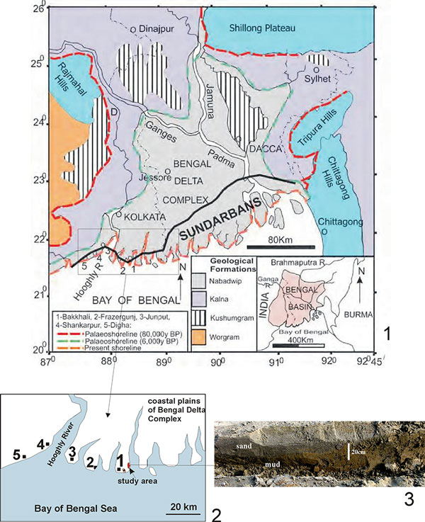
FIGURE 2. 1. A field photograph of referred sample area for detailed study showing prolific growth of Uca lactea mud-mounds on substrate having varied height, presence of mangrove bushes and spread of living Turritella spp. shells and distal creek. 2. Map prepared from sample study area shows distributions of simple mounds in high ground, compound mounds in low ground, Turritella spp. trails in low ground, mangrove bushes/plants and creek.
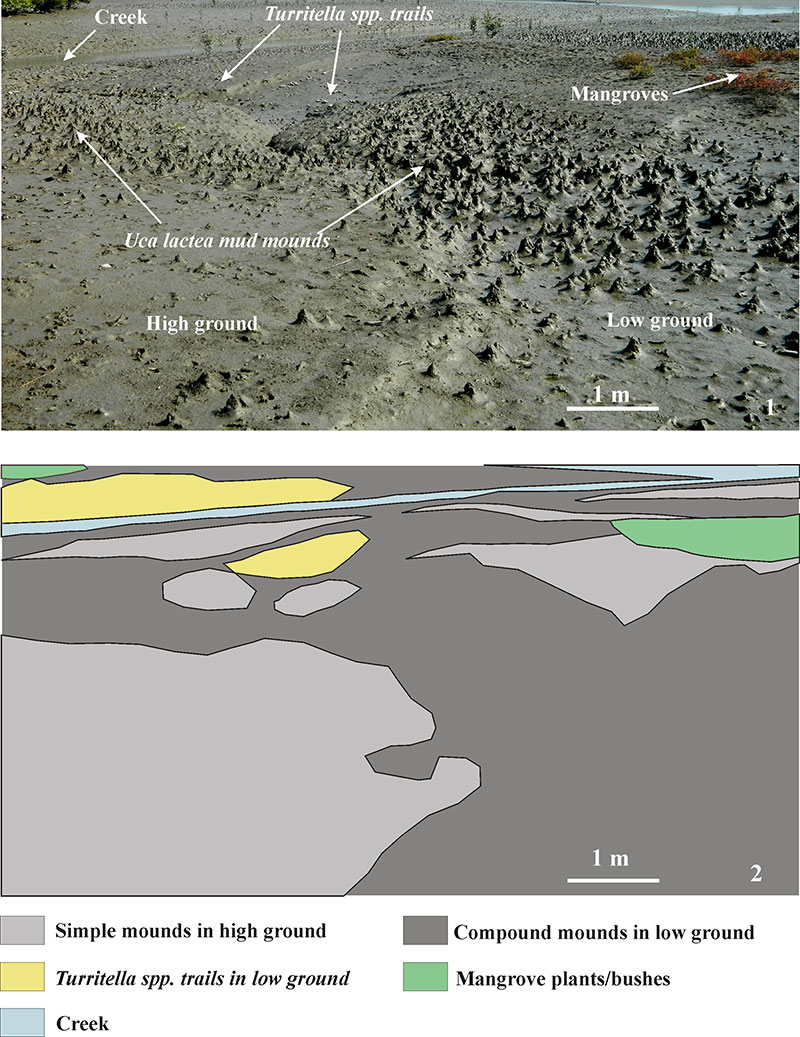
FIGURE 3. 1-2. White paraffin wax casts of the Uca lactea burrows in natural position in the field. Note simple un-branched I-shaped burrow morphology with lower bulged portion and narrow apertural neck. 3. Uca lactea simple mud-mound with a central circular burrow aperture. 4-5. Uca lactea compound mud-mounds with multiple circular to elliptical burrow apertures. 6. A compound mud-mound with projected down mud tongues (arrowed) denoting high water content of the mud slur. 7. Mud-mounds with apertural and rolled out mud lumps (arrowed) indicating low water content of the mud slur. 8. Mud-mound with mud rod (arrowed) ejected out of burrow mouth indicating paste-like viscosity of the mud slur. 9-11. Serial horizontal sections of mud-mound showing successive appearance of burrow openings (arrowed): one in top and three in base level showing downward bulging without any sign of convergence.
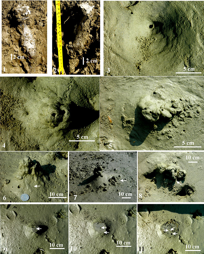
FIGURE 4. 1. Uca lactea burrow mouth with excavated loose sediment heaves or domes in relatively dry area. 2. Uca lactea mud chimney and surrounding substrate with mud clasts derived from collapsed mud-mounds and sorted out by tidal current, mud cracks and one trace producing crab (arrowed). 3. Ideal simple mud-mound of Uca lactea associated with feeding pellets arranged around burrow openings. 4. Network of Turritella spp. trails as observed after tidal wash out in low grounds. 5. Network of non-branching and radiating worm burrows (finer) in exposed and relatively dry mudflat. 6. Branching worm burrows (thicker) in exposed and relatively dry mudflat.

FIGURE 5. 1-6. Photographic illustrations arranged in order of gradual morphological transformation of simple (1) to compound mud-mounds (5-6) highlighting some possible morphological variants. Note greenish brown biomat coating on mud-mounds (1 and 5) that are microbially stabilized. The grey coloured mounds are yet to be stabilized.
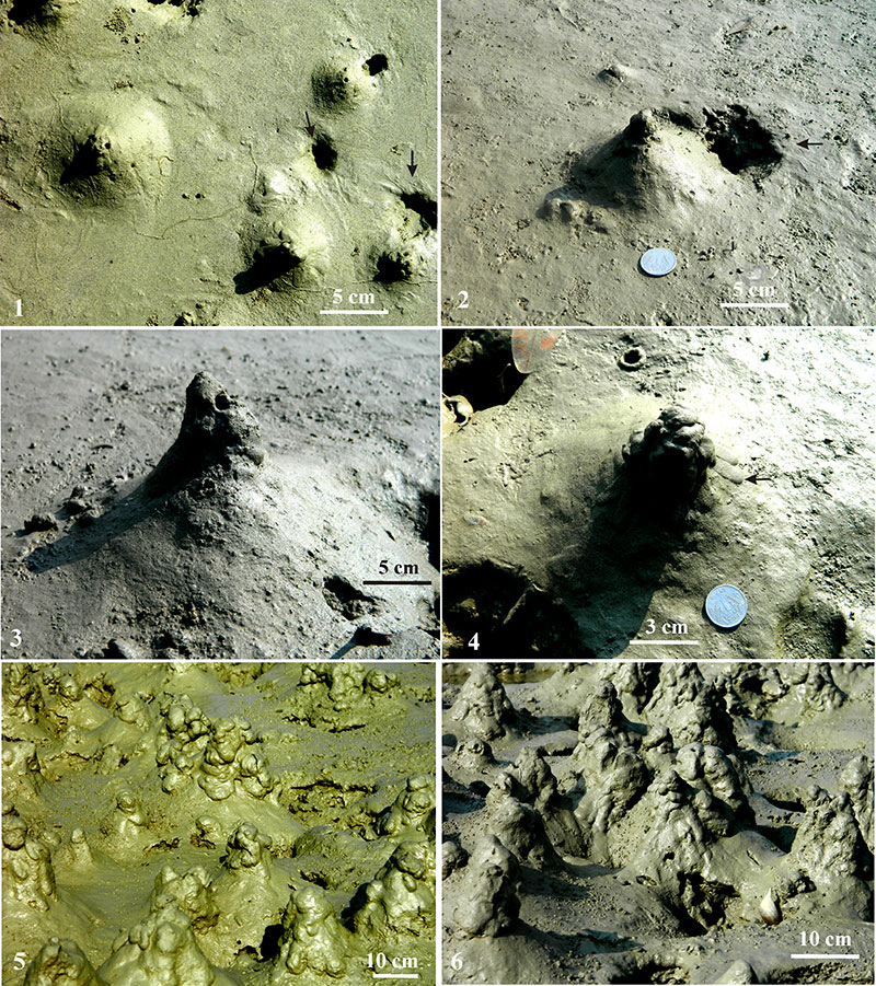
FIGURE 6. 1. A cluster of predominantly simple mud-mounds produced in high ground. 2-4. Photographs showing field occurrences of predominantly simple mud-mounds in higher ground. 5-11. Photographs showing field occurrences of predominantly compound mud-mounds in low ground. Note greenish brown biomat coating on mud-mounds (6-9 and 11) as a part microbial stabilization process. 12. Photograph illustrating ground elevation-based distribution of simple and compound mounds. (Note size variations, population density variations, surficial features, substrate ruggedness, variation in substrate elevation and different morphotypes of mud-mounds as observed in natural populations.)
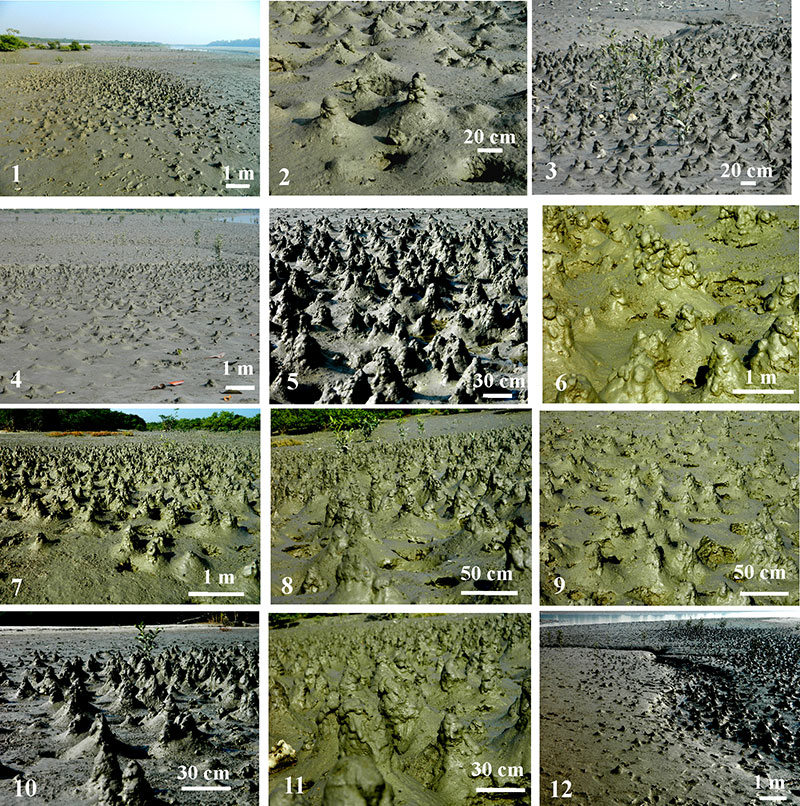
FIGURE 7. Schematic illustration of Uca lactea mud-mound building process as controlled by ground elevation and tidal recession. HTL stands for high tide level.
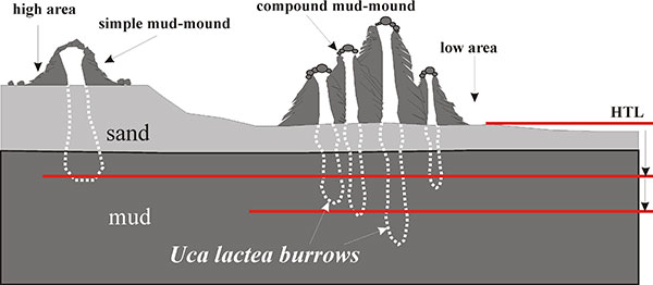
FIGURE 8. 1-2. Photographic illustrations of collapsed mounds (arrowed; circular to irregular depressions with central burrow opening(s) as observed immediately after high tide. 3. Rolled out mud balls, lumps and clasts derived from collapsed mud-mounds by tidal action.
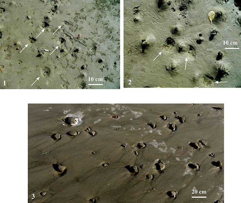
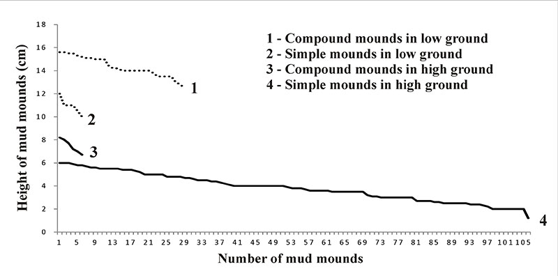
FIGURE 9. Vertical height variation curves of simple and compound mud-mounds (total 149 numbers) of Uca lactea in low and high grounds. Curve 1 - compound mounds (30 numbers with average height 14 cm) in low ground; Curve 2 - simple mounds (6 numbers with average height 11 cm) in low ground; Curve 3 - compound mounds (8 numbers with average height 7.5 cm) in high ground and Curve 4 - simple mounds (105 numbers with average height 4 cm) in high ground. Note shorter height of simple mounds relative to compound mounds irrespective of ground height and higher population of simple mounds in high ground and compound mounds in low ground.