FIGURE 1. Distribution of select pre-Rancholabrean Cenozoic rodent assemblages used to construct the database in Supplementary Material. 1 = Rancho el Ocote, MX; 2 = Concha, MX; 3 = Yepómera, MX; 4 = El Golfo, CA; 5 = Vallecito-Fish Creek sequence (e.g., Layer Cake, Arroyo Seco, Vallecito Creek), CA; 6 = San Pedro Valley sequence (e.g., Benson, Curtis Ranch, Duncan), AZ; 7 = Verde, AZ; 8 = McKay Reservoir, OR; 9 = Warren, CA; 10 = Panaca, NV; 11 = White Bluffs, WA; 12 = Kennewick, WA; 13 = Buckeye Creek, NV; 14 = Fish Springs Flat, NV; 15 = Grand View-Hagerman sequence (e.g., Grand View, Sand Point, Hagerman, Birch Creek, Froman Ferry), ID; 16 = Donnelly Ranch, CO; 17 = San Timoteo Badlands, CA; 18 = Wellington Hills, NV; 19 = Mesa del Sol, NM; 20 = Boyle Ditch, WY; 21 = Virden, NM; 22 = Ft. Selkirk, YT; 23 = El Casco, CA; 24 = SAM Cave , NM; 25 = Little Dell Dam, UT; 26 = Porcupine Cave, CO; 27 = Hansen Bluff, NM; 28 = Meade Basin reference section (see Figure 2 for all assemblages; includes Arlene’s Ledge/Robin’s Roost in OK), KS/NM; 29 = Little Sioux and Wright (new), IA; 30 = Cape Deceit, AL; 31 = Santee, NE; 32 = Mailbox, NE; 33 = Sand Draw area (Sand Draw, Zwiebel Channel), NE; 34 = Pipe Creek Sinkhole, IN; 35 = Hudspeth/Red Light, TX; 36 = Bull Draw/Deadman’s Crk, TX; 37 = Red Corral, TX; 38 = Cita Canyon, TX; 39 = Blanco, TX; 40 = Vera, TX; 41 = Beck Ranch, TX; 42 = Fyllan Cave, TX; 43 = Conard Fissure, AK; 44 = Port Kennedy Cave, PA; 45 = Hanover Quarry, PA; 46 = Cumberland Cave, MD; 47 = Haile 15A, Haile 16A, FL; 48 = Inglis 1A/1C, FL; 49 = Hamilton Cave, WV; 50 = White Rock, KS; 51 = Dixon, KS, 52 = Leisey Shell Pit, FL, 53 = Hoye Canyon, NV.
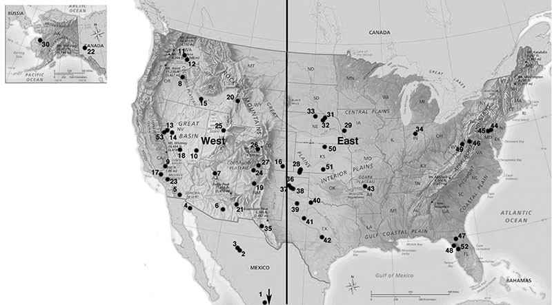
FIGURE 2. Depositional basin framework on which chronological ordering of assemblages (= localities) in Supplementary Material is mostly based. See Supplementary Material and text for full rodent communities, locality data, and information sources. LSD = lowest stratigraphic datum, HSD = highest stratigraphic datum. LSDs and HSDs are regional basin limits, but may also represent global limits (highest or lowest records anywhere in North America). Esr = estimated age based on sedimentation rate from Hart and Brueseke, 1999), ft = fission track date from Walkup et al., 2016), CMZ = Cenozoic Mammal Zone, xxx... = dated volcanic ash beds. For clarity this file is available in one continuous horizontal figure for download in the zipped Supplemental Material file.
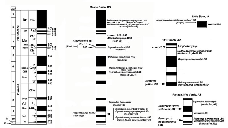
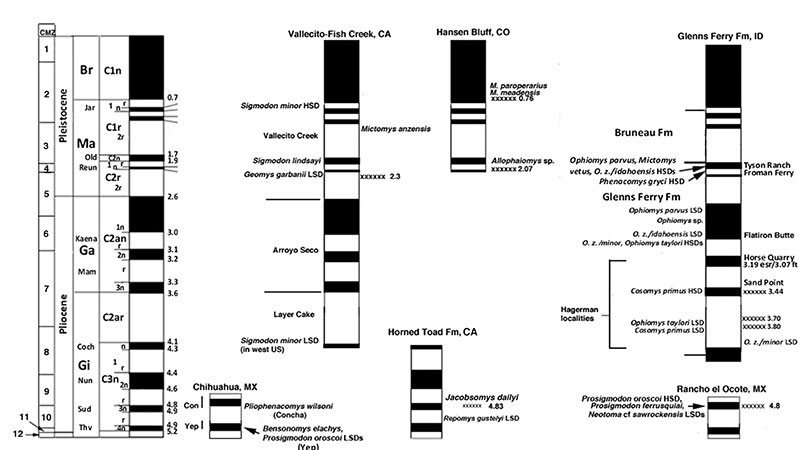
FIGURE 3. Examples of Microtus m1 morphology. A-C, Microtus pennsylvanicus (from Martin, 1990), D-F, Microtus paroperarius (from van der Meulen, 1978). ACC = anteroconid complex, BRA = buccal reentrant angle, LRA = lingual reentrant angle. Numbers in illustration D refer to triangle numbers.
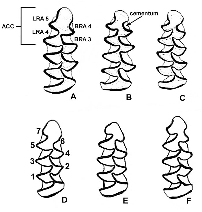
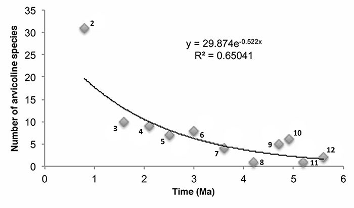
FIGURE 4. Plot of arvicoline species richness on ordinate against CMZ midpoints on abscissa. Numbers on graph are CMZs. CMZ 1 omitted.