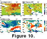
 Statistical
results for surface temperature changes (ºC), total precipitation (mm/day) are
summarised in Figure 10.
Statistical
results for surface temperature changes (ºC), total precipitation (mm/day) are
summarised in Figure 10.Statistical Analyses of Pliocene Control Results
Statistical analyses of the model output for the middle Pliocene control run
is a necessary step in trying to determine how much of the change in climatic
variables are truly due to the imposed Pliocene boundary conditions (PRISM2 data
set), or inter-annual variability within the model itself. In this study, a
threshold of 95 percent is considered significant. This does not automatically
imply that any simulated changes that do not achieve a 95 percent significance
level are not true representations of differences in the middle Pliocene
climate. Rather, they could represent either true variations or inter-annual
variability. Statistical
results for surface temperature changes (ºC), total precipitation (mm/day) are
summarised in Figure 10.
Statistical results for surface temperatures over North America as a whole suggest that much of the modelled differences in middle Pliocene surface temperatures from present-day are significant, especially during DJF. The improved significance during DJF can be attributed to the higher magnitude of surface temperature change predicted by the HadAM3 model during that season.
Statistical results for changes in total precipitation suggest that most of the predicted changes are significant. During JJA the geographical coverage of significant results is diminished compared to DJF. The difference between seasons can again be attributed to larger changes in precipitation occurring during DJF.
The geographical distribution of significant results for surface pressure (not shown in Figure 10) and wind strength changes is widespread over North America during DJF. This is, once again, a reflection of the magnitude of change in these variables during winter that are driven by changes to the high latitude, low and sub-tropical high-pressure cells.
Comparison to Geological Record
Comparison of the simulated regional climatic features produced by the GCM with Pliocene geological palaeoclimatic data has been carried out in a semi-quantitative fashion and is summarised as Table 1. Broadly, the comparison suggests that the climatic predictions generated by the HadAM3 over the USA are robust and agree with the data. The geological evidence of surface temperature warming of between 2º to 4ºC and enhanced winter warming over many areas of the USA (see boxes 1, 2, 3, 6, 8, and 10 on Figure 1) closely approximates the simulations of surface temperature changes predicted by the HadAM3 model. Furthermore, the simulated retreat of the freezing line during the middle Pliocene accords well with the fossil vertebrate record (Hibbard 1960; Auffenburg 1974; Graham 1986; Thompson 1991) of the USA, which suggests that freezing winters were absent on the central and southern Great Plains (Box 8: Figure 1). A simulated northward regression of the freezing line is not a unique feature produced by the HadAM3 model. Sloan et al. (1996) detected the same northward shift of the freezing line using the NCAR Genesis GCM and the PRISM1 data set.
In contrast to surface temperature, geological evidence for middle Pliocene hydrological characteristics exhibit great variability within the USA itself, thus making the assessment of the GCM predictions substantially harder. Furthermore, the weakness of the statistical testing results reduces our ability to evaluate the model predictions. Nevertheless, geological evidence from northern offshore, central, and interior regions of the USA (boxes 1, 2, 4, 8, and 10: Figure 1) including palaeolake levels and pollen support the assertion of an enhanced hydrological cycle during the middle Pliocene (Thompson 1991; Forester 1991; Thompson and Fleming 1996). Moreover, the geographical location of sites supporting higher precipitation levels in the northern USA coincide with the model-predicted zone of enhanced precipitation associated with the moisture bearing westerly wind belt. This suggests that the primary cause of the existence of large stable lakes or higher lake levels in northern areas of the USA suggested by the geological record (boxes 1, 2, and 4, Figure 1) is related to the higher winter precipitation level generated by the enhancement of westerly winds.
Evidence from fossil pollen, vertebrates, and soil carbonates support a pattern of enhanced precipitation in the southern USA on the eastern side of the western Cordillera of North America as well as further north (Box 10, Figure 1). This change in precipitation may have resulted from a reduced rain-shadow effect, produced by the lowered elevation of the mountain chain (Smith 1993; Thompson 1991; Thompson and Fleming 1996). Specifically, increases in rainfall have been suggested for Texas, Arizona, Nevada, and southern California. The HadAM3 models simulations of the middle Pliocene climate do not detect this trend of wetter conditions reconstructed from geological evidence.
There are numerous possible explanations for this data-model inconsistency. Firstly, the GCM may be incorrectly simulating the small scale effects on condensation and precipitation rates resulting from the change of orography associated with lowering the western Cordillera within the Pliocene control simulation as specified in the PRISM2 boundary conditions. However, this is unlikely as the model correctly simulates precipitation increases in the northern parts of the USA. Therefore, the simulated reduction in southerly winds that reduces the transport of moisture into southern and central areas of the USA is the most likely source of the data-model inconsistency.
Present-day predictions of precipitation amounts over the same area by the model show no dry anomalies when the outputs are compared to observed climatic data. Therefore, the reduced strength of southerly winds and consequent moisture transport in the southern and central areas of the USA must be linked to either an incorrect model response or deficiencies in PRISM2 boundary conditions. Any error in PRISM2 SST in the low latitudes and Gulf of Mexico region would lead to the GCM incorrectly representing changes in atmospheric circulation during the middle Pliocene for the area in question.
Heating or cooling air over mountaintops can produce strong density contrasts in the atmosphere compared with air masses over adjacent regions. This may result in strong rising or sinking motions in the atmosphere (Norris et al. 2000). Summer heating over a large mountain range produces a rising, low-density air mass, low atmospheric pressure over the mountains and thus strong winds blowing towards the mountain front. In the Northern Hemisphere, the winds blow counter clockwise around the range due to the Coriolis force. During winter, cooling of the mountain surfaces produces dense falling air masses that spread out away from the mountain front. In this case, Northern Hemisphere winds blow in a clockwise direction (Norris et al. 2000). The strength of the winds around mountains depends upon the breadth of the range and the strength of cooling produced by radiation from the land surface. Thus, the pattern of air movements around the western cordillera of North America will act to enhance the movement of southerly winds into the interior of the USA during JJA. However, PRISM2 specifies a 50 percent reduction in the elevation of this mountain chain. This will reduce the strength of counter clockwise air motion around the mountains and potentially affect the strength of southerly wind strength and hence precipitation over southern and central areas of the USA. The data-model inconstancy may therefore be a reflection of more sluggish counter clockwise air motion around the western cordillera of North America. Furthermore, it may indicate that the elevation of this mountain chain has been reduced in the PRISM2 data set erroneously or by a magnitude that is too great.
Data-model comparison of precipitation characteristics over the Great Plains region of the USA identifies another clear discrepancy between the geological record (Box 8, Figure 1) and the predictions of the HadAM3 model. While the model predictions mimic the geological record in terms of temperature changes in this area, simulated precipitation changes are opposite to the more humid conditions suggest by fossil vertebrates (Hibbard 1960; Auffenburg 1974; Graham 1986; Thompson 1991). The model simulations for precipitation change are not statistically significant over the Great Plains. However, with the uncertainties surrounding the statistical technique, these results alone are insufficient to ascribe the cause of the discrepancy to the model and not to our interpretation of the geological record. Firstly, the chronological control on the Pliocene vertebrate record of the USA is less robust than for other areas. Furthermore, the palaeoenvironmental interpretation derived from the Great Plains may be erroneous. Specifically, the existence of giant land tortoises on the Great Plains during the Pliocene may not be a reflection of enhanced temperatures and moisture levels. If the model predictions are robust, then this would suggest that temperature and the absence of freezing winters alone are the most significant driving forces in allowing the advancement northward of giant land tortoises in the USA. If not, then the most likely cause of the error relates to the deficiencies discussed in the last paragraph, namely the models underestimation of the strength of southerly winds that transport moisture inland from the Gulf of Mexico.
High resolution core records taken from the Glenns Ferry Formation in Idaho (Thompson 1996) and the Black Rock and Pit of Death in Utah (Thompson et al. 1995), all suggest that warmer and wetter conditions existed during the middle Pliocene in the USA, and as such support the simulations provided by the HadAM3 (boxes 2 and 4, Figure 1). However, within the overall trend, significant and frequent variations in moisture and temperature are detected via pollen and magnetic susceptibility changes within the respective cores. For the Glenns Ferry Formation, the periodicities of these variations do not appear to match any known Milankovitch astronomical time frame (Thompson 1996). However, oscillations in the Milankovitch-band frequencies, specifically the 41 kyr obliquity cycle, have been detected for the Pliocene from marine records (Tiedemann et al. 1994) and also from terrestrial diatom records at Tulelake in northern California (Adam et al. 1990).
The palaeoclimate modelling results presented in this paper reflect a simple snap shot for the middle Pliocene. Clearly, this approach is insufficient in the light of geological evidence suggesting climatic variation within the middle Pliocene. Future modelling studies should aim to address the issue of climatic variability within the middle Pliocene by the use of sensitivity experiments that alter orbital parameters. Results from such model experiments can then be evaluated against geological evidence to better assess the predictions of the GCM.
BIOME 4 Result
The biome map for the North American continent during the middle Pliocene, generated by BIOME 4 and the climatic output of the HadAM3 model, can be compared to the PRISM2 distribution of vegetation types over the region. The aim of such an approach is to assess how well the simulated climate produced by HadAM3-BIOME 4 for the middle Pliocene mimics the boundary conditions imposed into it. If the model predictions are robust, then the biome distributions that are predicted by BIOME 4 should closely approximate those in PRISM2 that were used as part of the boundary conditions for the GCM.
Several difficulties are implicit with such an approach. The first centres around the accuracy of the PRISM2 boundary conditions imposed in the model. If certain boundary conditions within the PRISM2 reconstruction are erroneous or out of phase with one another then the resulting climate and biome simulation will be wrong. Under these circumstances it is very unlikely that the biome distribution for North America produced by BIOME 4 will match that described in PRISM2.
Secondly, great care is required in determining whether any observed discrepancies are related to the model, or differences in the biome classification schemes used in BIOME 4 and PRISM2. PRISM2 uses a simplified seven-stage classification of the Hansen et al. (1983) biome scheme. Grassland, steppe, and savanna type vegetation are all incorporated into one classification due to difficulties in distinguishing between them with pollen evidence (Thompson and Fleming 1996). In contrast, BIOME 4 uses an advanced classification of 23 different biomes. It is important to remember that the BIOME models, just like the HadAM3, represent simplifications of reality and therefore are open to potential sources of error just as any other models (Williamson et al. 1998).
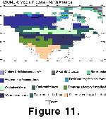 At
first sight, the HadAM3-BIOME 4 models predicted only a few biomes in locations
generally similar to PRISM2 biome distributions (Figure
11). However, most of this discrepancy is attributed to the differing
classification schemes between BIOME 4 and PRISM2. BIOME 4 does correctly
capture the expansion of forested areas north and the concurrent retreat of
barren and tundra areas that is a key characteristic of the reconstructed middle
Pliocene vegetation distribution, compared with present-day (Thompson
and Fleming 1996; Dowsett
et al. 1999). Comparison of the locations of biome boundaries between the
BIOME 4 and PRISM2 is virtually impossible due to the different classification
schemes used in both biome reconstructions. However, the latitude boundary at
which tundra climates become common is similar between both biome
reconstructions, as is the latitude when forest types switch from warm or cool
mixed to colder forms.
At
first sight, the HadAM3-BIOME 4 models predicted only a few biomes in locations
generally similar to PRISM2 biome distributions (Figure
11). However, most of this discrepancy is attributed to the differing
classification schemes between BIOME 4 and PRISM2. BIOME 4 does correctly
capture the expansion of forested areas north and the concurrent retreat of
barren and tundra areas that is a key characteristic of the reconstructed middle
Pliocene vegetation distribution, compared with present-day (Thompson
and Fleming 1996; Dowsett
et al. 1999). Comparison of the locations of biome boundaries between the
BIOME 4 and PRISM2 is virtually impossible due to the different classification
schemes used in both biome reconstructions. However, the latitude boundary at
which tundra climates become common is similar between both biome
reconstructions, as is the latitude when forest types switch from warm or cool
mixed to colder forms.
Nevertheless, the BIOME 4 results show significant variation from the imposed PRISM2 biomes that cannot be explained by the classification problem alone. Firstly, BIOME 4 predicts a significant advance of biomes representing desert or arid areas compared with PRISM2 in eastern and central areas of the southern USA. Specifically, the geographical distribution of xerophytic shrubland moves northward and eastward compared to the reconstructions of desert areas in PRISM2. We believe that this discrepancy reflects the dryer than expected conditions predicted by the HadAM3 for this region in the Pliocene control experiment.
Secondly, BIOME 4 completely fails to predict the presence of grassland in the western USA. In contrast, PRISM2 suggests that grasslands cover a significant geographical area of that region. This may suggest that the HadAM3 model could be over estimating precipitation levels in the higher latitudes of the western USA.
Thirdly, BIOME 4 predicts temperate conifer forest over parts of the southeast USA where PRISM2 identifies deciduous woodland. The results of our Pliocene sensitivity experiment have demonstrated that, at least for this area of the USA, the prescribed PRISM2 SST are primarily responsible for forcing the simulated changes in the middle Pliocene climate. PRISM2 SST reconstructions for coastal areas around this region of the USA are slightly warmer (1º to 2ºC), the same or slightly cooler (0.5º to 1ºC) than present during certain months of the year (see Dowsett et al. 1999). In this case, the available evidence suggests that the PRISM2 biomes and SST could be out of phase with one another leading to an underestimation of surface temperature change in the middle Pliocene control experiment over this region by the HadAM3 model.
![]()