 The most
complete profile for describing the different components, although not the
thickest, is described as follows. It comes from the eastern face of [the
ravine]
The most
complete profile for describing the different components, although not the
thickest, is described as follows. It comes from the eastern face of [the
ravine] In northwestern Shansi, in the region of Pao-Te-Hsien [Baode county], is one of the centres of the trade of fossil bones in northern China. Pao-Te-Hsien itself is located eight days travel northwest from the provincial capital Tai-Yuan-Fu [Taiyuan city], on the Yellow River. The area considered is northeast of Pao-Te-Hsien and has its centre approximately in Chi-Chia-Kou [Jijiagou], about 13 km to the northeast of the town.
The land is a plateau rising towards the east from the Yellow River on the west. It is, however, cut by ravines and gullies, giving the impression of a hilly landscape, until a view from a greater distance reveals the evenness of the overall rise.
The attached map shows the region’s topography and geology. As can be seen, almost all the valleys reach the Carboniferous (base), in which the water has often carved canyons of 10-15 m depth. Coal can be found almost everywhere, and it is quarried from several mines, however, mostly for domestic use. In general, the Carboniferous lies horizontally, but locally the beds can also be slightly folded. At the boundary between the Carboniferous and the overlying Hipparion Clay, small springs are often to be found.
In a very small area (which can be partially seen in the northwest corner of the map) above the Carboniferous unit, there are layers, the precise age of which should be determinable after study of the collected fossils. For the time being, the name Lu-Tzu-Kou Series is proposed, according to the main locality. The geographical extent of these sediments is restricted to the valley where the village of Chung-Lu-Tzu-Kou [Zhongluzigou] is located, with its side valleys and the northern parallel valley. These sediments cannot be found either in the north, south, or east, but during a trip to Nan-Sha-Wa [Nanshawa] the author saw (about 30 km north of Chi-Chia-Kou) a 30-cm thick bed of quartz cobbles between the Carboniferous unit and the Hipparion Clay. This probably is part of the Lu-Tzu-Kou Series. Westward these extend as far as the Yellow River.
At Chung-Lu-Tzu-Kou [Zhongluzigou], the strata occasionally reach a maximum thickness of 25 to 30 m, although in the closest proximity, sediments of lesser thickness can also be found. The series begins above the Carboniferous unit with a layer of quartz shingle (a piece of jadeite was also found in it). The spaces between the clasts are filled with yellow and green quartz sand. Here and there, where the cementing is stronger, a massive bed of conglomerate occurs. Lenses of fine sand and fragments of green marl with fish remains occur as inclusions. These gravel layers include moderately rounded bone fragments and teeth of larger mammals. Among the finds were isolated teeth of an equid, a rhinocerid, and a rodent. Overlying the gravel follows the green-yellow marl and carbonaceous marl with freshwater molluscs and impressions of plants. Overlying these are crossbedded fine yellow sands. A rhinoceros mandible was found in these. An important horizon consists of greenish-white, stratified, calcareous marl, which in places is quite filled with fish remains. Additionally, a smaller amount of molluscs can be found, although in many places in the same horizon, this can be quite the reverse (i.e., more molluscs than fish). Thus far, it can be stated that the molluscs are represented by two species of gastropods and lamellibranchiates each.
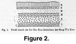
The most
complete profile for describing the different components, although not the
thickest, is described as follows. It comes from the eastern face of [the
ravine]
Sang-T’a-Kou [Sangdagou], which opens in the main valley southeast of Chung-Lu-Tzu-Kou [Zhongluzigou]. It can be seen in Figure 2 and Figure 3.
VI. More than 4 m of reddish, loess-like material with bone splinters and tooth fragments of rhinoceros in a layer with calcium carbonate concretions at the base.
V. 1.3 m of greenish-white, stratified, calcareous marl with plenty of bone splinters of larger mammals and molluscs.
IV. 4.5 m of fine yellow sands with crossbedding. Mandible of Rhinoceros.
III. 2.3 m of green-yellow marls and calcareous marls with fish fossils and molluscs.
II. 6.5 m of quartz cobbles, the interstices filled with yellow and green sands. In places iron-stained and hardened. Contains lenses of green sand and blocks of marl. Includes rounded bone fragments and teeth of mammals.
I. Carboniferous.
 The red
sediment that caps this sequence cannot, as so often happens, be distinguished
either from loess or from Hipparion Clay with certainty. Because of this, this
profile does not give a satisfactory answer to the question of the relationship
of the Lu-Tzu-Kou series to the Hipparion Clay, but the problem is solved
through a profile of Ch’I-Tzu-Kou [Qizigou], which is a parallel valley of
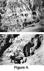
Lu-Tzu-Kou [Luzigou]. The latter can be seen in
Figure 4. The abandoned cave
dwellings, the two entrances of which can be seen, are still situated in the
deposits concerned. In this particular place, these deposits form a harder
carbonate bank that is rich with fish fossils. But overlying this, with a
sharp contact, is the Hipparion Clay, recognised as such not only by its clearly
distinguishable petrographic nature, but also through its fossil content.
The red
sediment that caps this sequence cannot, as so often happens, be distinguished
either from loess or from Hipparion Clay with certainty. Because of this, this
profile does not give a satisfactory answer to the question of the relationship
of the Lu-Tzu-Kou series to the Hipparion Clay, but the problem is solved
through a profile of Ch’I-Tzu-Kou [Qizigou], which is a parallel valley of
Lu-Tzu-Kou [Luzigou]. The latter can be seen in
Figure 4. The abandoned cave
dwellings, the two entrances of which can be seen, are still situated in the
deposits concerned. In this particular place, these deposits form a harder
carbonate bank that is rich with fish fossils. But overlying this, with a
sharp contact, is the Hipparion Clay, recognised as such not only by its clearly
distinguishable petrographic nature, but also through its fossil content.
In Lun-Ch’üh-Kou [Lunqugou?] (visible on map), a layer of greenish carbonate marl, rich in gastropods and with some fish fossils, appears in a red clay, that appears extremely similar to the Hipparion Clay. Until the fossil material is studied, preliminary survey and geological considerations suggest a Miocene age for the Lu-Tzu-Kou series. The stratification is horizontal.
![]()