GEOLOGICAL SIGNIFICANCE OF THE UPPER MEKONG RIVER
AND
ITS TRIBUTARIES
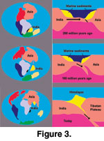 By the mid 1970s, the theory that the Himalayas
were produced by a collision between India and Asia was becoming widely accepted
(Figure 3), but it raised major questions regarding the displaced mass of Asian
crust. Since about 50 mya, it appeared that India had penetrated at least 2000
km into Asia, but it was not clear that the mass of the Himalayas and the
thickened crust beneath the Tibetan Plateau were sufficient to account for the
entire mass of displaced Asian crust.
By the mid 1970s, the theory that the Himalayas
were produced by a collision between India and Asia was becoming widely accepted
(Figure 3), but it raised major questions regarding the displaced mass of Asian
crust. Since about 50 mya, it appeared that India had penetrated at least 2000
km into Asia, but it was not clear that the mass of the Himalayas and the
thickened crust beneath the Tibetan Plateau were sufficient to account for the
entire mass of displaced Asian crust.
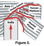
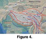 Using satellite images and seismic
analysis,
Molnar and Tapponnier (1975) recognized major east-trending,
left-lateral strike-slip faults emanating from Tibet. These faults sliced the
areas east and southeast of Tibet, implying that crustal mass north of the
Himalayas was shifting eastward and southeastward as India moved north (Figure
4). Molnar and Tapponnier hypothesized that the Yunnan Plateau and the Shan-Thai
Plateau are now much further southeast than they were before the collision
(Figure 5).
Using satellite images and seismic
analysis,
Molnar and Tapponnier (1975) recognized major east-trending,
left-lateral strike-slip faults emanating from Tibet. These faults sliced the
areas east and southeast of Tibet, implying that crustal mass north of the
Himalayas was shifting eastward and southeastward as India moved north (Figure
4). Molnar and Tapponnier hypothesized that the Yunnan Plateau and the Shan-Thai
Plateau are now much further southeast than they were before the collision
(Figure 5).
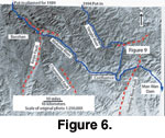
 We decided that the Mekong River Canyon in western
Yunnan was the best region for examining faults to determine whether large
blocks of southeast Asian crust were being extruded southward towards Indochina.
The river crosses several faults in a canyon two miles deep in the stretch where
it changes direction from south to southeast (Figure 6). We hoped to investigate
the nature of these faults to determine their relationship to the development of
the Himalayas and the uplift of the Tibetan Plateau.
We decided that the Mekong River Canyon in western
Yunnan was the best region for examining faults to determine whether large
blocks of southeast Asian crust were being extruded southward towards Indochina.
The river crosses several faults in a canyon two miles deep in the stretch where
it changes direction from south to southeast (Figure 6). We hoped to investigate
the nature of these faults to determine their relationship to the development of
the Himalayas and the uplift of the Tibetan Plateau.
 To achieve this
objective, our plan was to determine the sense of shear in mylonites, to sample
shear zones for radiometric dating, and to sample overlying Triassic red beds to
measure paleomagnetic latitude and orientation. Mylonites are fault rocks, which
are cohesive, characterized by a well-developed schistosity resulting from
tectonic reduction of grain size, and commonly contain rounded porphyroclasts
and lithic fragments similar in composition to the matrix minerals. Fine scale
layering and an associated mineral or stretching lineation are commonly present.
Brittle deformation of some minerals may be present, but deformation is commonly
by crystal plasticity (Brodie et al. 2004).
To achieve this
objective, our plan was to determine the sense of shear in mylonites, to sample
shear zones for radiometric dating, and to sample overlying Triassic red beds to
measure paleomagnetic latitude and orientation. Mylonites are fault rocks, which
are cohesive, characterized by a well-developed schistosity resulting from
tectonic reduction of grain size, and commonly contain rounded porphyroclasts
and lithic fragments similar in composition to the matrix minerals. Fine scale
layering and an associated mineral or stretching lineation are commonly present.
Brittle deformation of some minerals may be present, but deformation is commonly
by crystal plasticity (Brodie et al. 2004).
A related objective
was to take paleontological samples in hopes of justifying further research on
patterns of environmental change as the rising Himalayas modified the climate of
this area. Will was one of the oarsmen and the only paleontologist on the team.
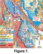 In southwestern Yunnan,
the Mekong River weaves back and forth across the contact between metamorphic
rock units and Mesozoic sedimentary strata (Figure 7). According to Chinese
geologists, the metamorphic rocks are of amphibolite grade, and therefore
temperatures in them have exceeded 450°C. More importantly, the metamorphic
rocks are strongly sheared, with a near vertical northwest-trending foliation
and subhorizontal lineation characteristic of rocks that have experienced high
shear. Neither the sense of shear nor their age was known. On Chinese maps, the
sedimentary rocks were shown as Jurassic and Cretaceous shallow marine deposits
in fault contact with the underlying metamorphic rocks. Determining the nature
of this contact was an important part of our research proposal.
In southwestern Yunnan,
the Mekong River weaves back and forth across the contact between metamorphic
rock units and Mesozoic sedimentary strata (Figure 7). According to Chinese
geologists, the metamorphic rocks are of amphibolite grade, and therefore
temperatures in them have exceeded 450°C. More importantly, the metamorphic
rocks are strongly sheared, with a near vertical northwest-trending foliation
and subhorizontal lineation characteristic of rocks that have experienced high
shear. Neither the sense of shear nor their age was known. On Chinese maps, the
sedimentary rocks were shown as Jurassic and Cretaceous shallow marine deposits
in fault contact with the underlying metamorphic rocks. Determining the nature
of this contact was an important part of our research proposal.
In summary, we planned to examine in detail the
deformation and rotation of rocks exposed along the Mekong River in western
Yunnan to characterize the age, style, intensity, distribution, and sense of
crustal shearing induced by the collision and penetration of India into Asia. We
hoped to constrain the extent and the timing of extrusion of parts of Indochina
from an initially more northwesterly position and to place bounds on the amount
and distribution of shearing in western Yunnan due to India sliding northward
past Yunnan. We believed that a detailed study of one key area was a better
approach than a superficial examination of a large area.
The stretch of Mekong that we planned to run
appeared to offer a wide range of possible approaches to studying this
deformation. Knowledge gained from this area would be fundamental to
understanding areas of more complex deformation in northern Yunnan, western
Sichuan, Tibet, and Qinghai. We hoped to expand our collaborative research
program to these regions, concentrating on areas where our collective expertise
could have been used to maximize the results of our research. Although Will’s
scientific background and interest were generally limited to the paleontological
aspects of this expedition, his role as an experienced whitewater river guide
who could read, write, and speak Mandarin was critical to the success of the
expedition.
