PREVIOUS STUDIES OF THE UPPER CARBONIFEROUS (PENNSYLVANIAN)
DEPOSITS OF EASTERN AND CENTRAL IRAN
Data on the Upper Carboniferous and Lower Permian sequences in Central and Eastern Iran were obtained in the 1960s in the course of the geological mapping of the Tabas area (Stöcklin et al. 1965;
Ruttner and Stöcklin 1966;
Ruttner et al. 1968).
Stepanov (1971) and
Stöcklin (1971) published comprehensive stratigraphic and paleontologic data about this region. The Devonian through Carboniferous deposits of this region include the Shishtu and Sardar Formations.The former spans the Upper Devonian through the lower half of the Visean. The type section of the Shishtu Formation is located in the Ozbak-Kuh Mountains, north of Tabas and consists of alternating shale, marl, and limestone. The Sardar "Formation" was established in the Shotori Mountains, east of Tabas city (Stöcklin et al. 1965). The lower portion of Sardar was described as sequences of interbedded shale, sandstone, and limestone and the upper portion as predominantly shale with sandstone (Stöcklin et al. 1965).
The thickness of the Sardar "Formation" varies from 280 to 660 m and unconformably overlies the limestone and shale of the Shishtu Formation, and is characterized by a 30 m thick basal conglomerate. The Sardar "Formation" is overlaid by massive beds of limestone and dolomite of the Jamal Formation. A thin coal bed occurs irregularly at the sharp contact between these two units. The presence of the coal bed and the difference in lithology suggest an unconformable contact between the Jamal and Sardar Formations.
The Sardar "Formation" was recognized in the Shirgesht area and in the Ozbak-Kuh Mountains and was divided into two sub-formations, (i.e., Sardar 1 and Sardar 2;
Ruttner et al. 1968). In Shirgesht, it is represented by sequences more than 1000 m thick of shale, siltstone, and sandstone that contain infrequent thin interbeds of sandy and crinoidal limestone. The Sardar "Formation" in this area has no contact with the Shishtu Formation and is unconformably overlaid by Jurassic deposits (Ruttner et al. 1968). In the Ozbak-Kuh Mountain, the lower portion of the Sardar
"Formation" is rich in carbonate rocks.
Geological mapping by Russian geologists revealed an analog of the Sardar "Formation" in the Anarak section (Sharkovski et al. 1984) with a thickness of up to 300 m of sandstone and shale, with highly fossiliferous limestone interbeds. The interrelationships of deposits lying above and below are unclear. The Sardar "Formation" was purportedly overlain by limestone with a basal horizon of pink sandstone. This limestone previously was assigned to the Jamal Formation. The Early Permian (Asselian-Sakmarian) fusulinids, bryozoans, and brachiopods occurring in the limestone, however, imply a relationship with the Late Pennsylvanian-Asselian Zaladu Formation rather than to the Upper Permian Jamal Formation (Leven and Taheri 2003).
The Sardar "Formation" was loosely dated as late Visean-Permian on the basis of ammonoids, brachiopods, and corals, which are occasionally preserved in the rocks (Stöcklin et al. 1965;
Walliser 1966;
Stepanov 1971). A confident late Visean age of the lower part of the formation was established exclusively by brachiopods in the type section at Shotori Mountain. Elsewhere, the age of Sadar is somewhat dubious.
Stepanov (1971) referred Sardar 1 to the upper Visean-lower Namurian interval; the Namurian portion being unspecified. Therefore, in terms of the recent chronostratigraphic scale, the age of Sardar 1 could be interpreted as late Visean-early Bashkirian. Sardar 2 was assigned to the Upper Carboniferous (Silesian)-Lower Permian, or, Bashkirian-Lower Permian (Stepanov 1971) on the basis of the Early Pennsylvanian (Bashkirian) goniatite Gastrioceras (Branneroceras) cf. branneri
in the lower part of the sub-formation (Walliser 1966) and Early Permian brachiopods near the top of the Sardar 2 (Stepanov 1971).
Partoazar (1995) restricted the age for the Sardar 2 to Moscovian, however, no justification was given for this assignment.
It should be noted that before our investigation, age assignments of the Sardar "Formation" were based on limited, discrepant information. With few exceptions, most of the paleontological collections were never described, affecting the accuracy of dating. Samplings of micro-faunas were far from adequate. Conodonts from the underlying Devonian-Mississippian were described by
Weddige (1984).
 Pennsylvanian foraminifers in Iran were previously listed only from the eastern Alburz Mountains, near the Gorgan town area, northern Iran, (Bozorgnia 1973;
Jenny et al. 1978;
Lys 1986). Their occurrence in Eastern and Central Iran was reported but they were never described.
Vachard (1996) figured
few poorly oriented Moscovian fusulinids from J. Jenny's collections of the Gheselghaleh area, northern Iran.
Pennsylvanian foraminifers in Iran were previously listed only from the eastern Alburz Mountains, near the Gorgan town area, northern Iran, (Bozorgnia 1973;
Jenny et al. 1978;
Lys 1986). Their occurrence in Eastern and Central Iran was reported but they were never described.
Vachard (1996) figured
few poorly oriented Moscovian fusulinids from J. Jenny's collections of the Gheselghaleh area, northern Iran.
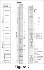
The common occurrences of foraminifers in the Zaladu section (at 53 stratigraphic levels) and Anarak section (at 60 levels) provide a solid basis for chronostratigraphic calibration of the Sardar "Formation" (Figure 2). Several stratigraphic unconformities were recognized, both within the formation and at their boundaries. For the first time, a significant gap can be well documented between Sardar 1 and Sardar 2, allowing for the establishment of those units as new formations. The type sections for the Formations occur at the western slope of Zaladu valley in the Ozbak-Kuh Mountains.
