| |
DISCUSSION: PALEOENVIRONMENTAL INTERPRETATION
Integration of sedimentological and ichnological data for the Coste dell'Anglone ichnosite is of particular interest not only for its bearing on the paleogeographic reconstruction of this restricted setting but, more importantly, for its possible contribution to the ongoing debate on the palaeogoeography of the Trento Platform during the Early Jurassic (e.g.,
Petti et al. 2009a). Since its recognition in the early 1970s, the sedimentary cover of the Southern Alps has been interpreted as one of the best preserved section of the southern continental margin of the Mesozoic Tethys, characterized by a horst and graben structure inherited from rifting closely related to the opening of the central North Atlantic (Castellarin and Picotti 1990;
Castellarin et al. 1992). The rifting phase took place in the Late Triassic and the Early Jurassic and produced high-standing blocks separated by troughs. All of the western sector of the margin (Piedmont and Lombardy) rapidly drowned in the Early Liassic whereas in the eastern part, some sectors kept their shallow water sedimentation conditions. These are, from east to west, the Friuli Platform, a carbonate platform that persisted from the Jurassic until the Cretaceous and the Trento Platform drowned at the end of Early Jurassic, when evolved into a pelagic plateau with condensed sedimentation during the Late Jurassic. These platforms have been pulled apart by a pelagic basin formed during the Hettangian (Belluno Basin). The Trento Platform covers a wide area in northeastern Italy, extending north-south from Verona to Bolzano. Westward the Trento Platform is separated from the Lombardian basin by the "Garda escarpment" fault system, which was active during the Jurassic and Cretaceous. The prolongation of the platform to the south-west has been hypothesized through the integrated analysis of surface and subsurface data (see
Masetti et al. 2006).
The thick Calcari Grigi Group (Hettangian-Pliensbachian) corresponds to the Early Jurassic shallow-water sedimentation phase of the Trento Platform. In the last 15 years the search for dinosaur tracksites on the Lower Jurassic Trento Platform, led to the discovery of several sites scattered across an area of about 1,500 km2. The continuity of dinosaur occurrence on the Trento Platform in the Hettangian-Sinemurian interval suggests a stable link of the Southern Alps carbonate tidal flats with emerged and vegetated lands and with freshwater supplies, but the localization of these lands or of wide "continental bridges" is still unresolved.
The numerous sedimentological and stratigraphical works carried out on the Calcari Grigi Group allowed to finely describe its paleoenviromental setting during the Early Jurassic (see
Avanzini et al. 2006 for a review of the unit). Particularly the Rotzo Formation has always been interpreted as a shallow subtidal platform environment, with gently inclined depositional ramp and inner lagoon bordered by ooolitic shoals.
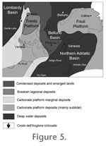 The Coste dell'Anglone ichnosite was located on the margin of this lagoon, more exactly on the sandy barrier complex that separates the open sea toward the west (Lombardy basin) from the lagoon and the inner carbonate platform toward the East (Figure 5). In this environment the flora was dominated by pioneer plants (such as Cheirolepidiacea) that lived neighboring the coasts favoring semi-arid environments (Petti et al. 2009b). The Coste dell'Anglone ichnosite was located on the margin of this lagoon, more exactly on the sandy barrier complex that separates the open sea toward the west (Lombardy basin) from the lagoon and the inner carbonate platform toward the East (Figure 5). In this environment the flora was dominated by pioneer plants (such as Cheirolepidiacea) that lived neighboring the coasts favoring semi-arid environments (Petti et al. 2009b).
The recovery of the Asteriacites ichnoassemblage offers the possibility to better define this paleoenvironment. Asteriacites is recorded in marginal-marine, tidal-flat facies and is generally considered as indicative of fully oxygenated (Müller 1980;
Mikuláš 1992;
Twitchett and Wignall 1996) and clear waters (Kilbourne et al. 1998; see also
Kesling and Le Vasseur 1971 and
Mikuláš 1990,
1992). Facies analysis, indicating sedimentation in sand, mixed sand-mud, and intertidal flats (i.e., channel and pond subenvironments) is consistent with this suggestion. Sedimentary structures are indicative of shallow water tidal environment, and the observed heterolitic stratification indicates the presence of steady flows at low current velocities. The occurrence of dinosaur tracks and other supratidal markers (mud cracks, sheet crack, oxidized shells, reddish film of soils) provide evidences for repeated subaerial exposures of this sector considered up to now as fully subtidal.
Asteriacites has been also shown to be common in brackish-water conditions (Mángano et al. 1999). This is consistent with the possible presence of a fresh water source in a not too far area that would have been necessary to sustain the existence of the sedentary populations of dinosaurs documented in the Coste dell'Anglone site. Present data, however, are insufficient to test this hypothesis.
Here presented data are consistent with the interpretations of
Bosellini and Broglio Loriga (1971) and
Masetti et al. (1998) that envisaged a lagoon-barrier island complex scenario for this unit during the Sinemurian with a subtidal ramp gently inclined to the west and an intertidal-supratidal barrier island complex, trending approximately N-S, now corresponding to Mt. Brento-Mt. Biaina and Mt. Baldo chains (ramp-lagoonal model).
|