 The Siwalik sequence has been recognized for its
rich terrestrial vertebrate record since the 1830's, and the extensive Potwar
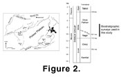
Plateau exposures in northern Pakistan (Figure 2)
have been under investigation by the Harvard - Geological Survey of Pakistan -
Smithsonian team since the early 1970's. This project, headed by David Pilbeam,
S. Ibrahim Shah, S. Mahmood Raza and J. C. Barry, has been multidisciplinary in
scope and has yielded a wealth of geochronological, sedimentological and
paleontological information for over 5000 m of fluvial deposits spanning the
time period between about 18 and 5 Ma (Johnson
et al., 1985; recent summary in
Barry et al. 2002).
The Miocene–Pliocene strata have traditionally been divided into the Kamlial,
Chinji, Nagri, and Dhok Pathan Formations (Figure 2).
In all of these formations, exposures typically consist of gently tilted strata
that form shallow strike-valleys and higher ridges as the surface expression of
the large structural synclinorium underlying the Potwar Plateau. The ridges are
formed by laterally extensive channel sandstones and the valleys by more easily
eroded floodplain mudstones and siltstones (Willis
and Behrensmeyer 1994). Fossils weather out of these strata and accumulate
on the outcrop surfaces between the ridges, providing ideal conditions for controlled
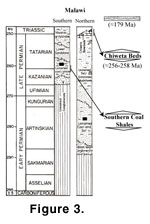
sampling within well-defined stratigraphic intervals (Figure 3).
The Siwalik sequence has been recognized for its
rich terrestrial vertebrate record since the 1830's, and the extensive Potwar
Plateau exposures in northern Pakistan (Figure 2)
have been under investigation by the Harvard - Geological Survey of Pakistan -
Smithsonian team since the early 1970's. This project, headed by David Pilbeam,
S. Ibrahim Shah, S. Mahmood Raza and J. C. Barry, has been multidisciplinary in
scope and has yielded a wealth of geochronological, sedimentological and
paleontological information for over 5000 m of fluvial deposits spanning the
time period between about 18 and 5 Ma (Johnson
et al., 1985; recent summary in
Barry et al. 2002).
The Miocene–Pliocene strata have traditionally been divided into the Kamlial,
Chinji, Nagri, and Dhok Pathan Formations (Figure 2).
In all of these formations, exposures typically consist of gently tilted strata
that form shallow strike-valleys and higher ridges as the surface expression of
the large structural synclinorium underlying the Potwar Plateau. The ridges are
formed by laterally extensive channel sandstones and the valleys by more easily
eroded floodplain mudstones and siltstones (Willis
and Behrensmeyer 1994). Fossils weather out of these strata and accumulate
on the outcrop surfaces between the ridges, providing ideal conditions for controlled
sampling within well-defined stratigraphic intervals (Figure 3).
 The
Potwar Plateau is capped by late Pleistocene silts and gravels (the Potwar
Silts), which buried an erosional unconformity on Mio-Pliocene sediments. In
many areas these overlying deposits have been removed by erosion, but in others
they cover the older sediments with silts or coarse gravels that limit recovery
of the Mio-Pliocene fossils.
The
Potwar Plateau is capped by late Pleistocene silts and gravels (the Potwar
Silts), which buried an erosional unconformity on Mio-Pliocene sediments. In
many areas these overlying deposits have been removed by erosion, but in others
they cover the older sediments with silts or coarse gravels that limit recovery
of the Mio-Pliocene fossils.The biostratigraphic surveys of Siwalik strata were done in many different areas of the Potwar Plateau; these areas are named for the modern drainages or ‘kas’ that typically cut through the exposures perpendicular to regional strike. In the Khaur region, located in the north-central Potwar, these include the following kas: Kaulial, Malhuwala, Dinga, Dhok Mila, Ganda, and Ratha (map positions provided in Barry et al. 1980). Surveys also were done in the Rhotas area near the city of Jhelum and in the lower Chinji, upper Chinji/lowerNagri, and Kamlial Formations in the southern portion of the Potwar. Kaulial Kas, in particular, was a focal area for pinning down the level of first appearance of a “big bovid” using controlled surface surveying methods. The surveyed portion of the Kaulial Kas section consists of about 2100 m (6930 feet) spanning the time interval from 10.9 to about 7.1 Ma and is one of the few areas in the northern Potwar where the later part of this interval is well enough exposed to produce a reasonable fossil record. In both the Khaur and Chinji areas this approach also was used to define the “Hipparion” appearance level, and the resulting data support the assertion that equids do not occur lower than this level (Barry et al. 2002).