| |
HORNED TOAD FORMATION
 The Horned Toad Formation is exposed entirely within the Horned Toad Hills northwest of Mojave, California (Figure 2 and
Figure 3). The formation was named by Dibblee (1958) who proposed a threefold division into lower, middle, and upper members. These three members, as well as two new members, are recognized in the present study.
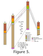
Dibblee (1959) published a "Preliminary Geologic Map of the Mojave Quadrangle" that included most of the Horned Toad Formation. A portion of this map, along with new data from the Tehachapi Quadrangle, was published by Dibblee (1967). The Horned Toad Formation consists primarily of arkosic sandstone and conglomeratic sandstone along with siltstone, clay, and rare volcanic tuff and chert. It is here subdivided into five lithologic members (Figure 3 and
Figure 5). The Horned Toad Formation is exposed entirely within the Horned Toad Hills northwest of Mojave, California (Figure 2 and
Figure 3). The formation was named by Dibblee (1958) who proposed a threefold division into lower, middle, and upper members. These three members, as well as two new members, are recognized in the present study.
Dibblee (1959) published a "Preliminary Geologic Map of the Mojave Quadrangle" that included most of the Horned Toad Formation. A portion of this map, along with new data from the Tehachapi Quadrangle, was published by Dibblee (1967). The Horned Toad Formation consists primarily of arkosic sandstone and conglomeratic sandstone along with siltstone, clay, and rare volcanic tuff and chert. It is here subdivided into five lithologic members (Figure 3 and
Figure 5).
Lithostratigraphy
 Member One – The basal member of the Horned Toad Formation is equivalent to
Dibblee's (1958) "Lower Member". This member has a maximum thickness of 297 m and is exposed for 9.5 km along the southeast flank of Cameron Ridge (Figure 3). The lower contact of Member One is a depositional nonconformity on Cameron Granodiorite and Bobtail Quartz Latite (Figure 4 and
Figure 5). Bedding attitudes near the contact are generally steep, but there is little evidence for structural deformation at the sediment-basement interface. Therefore, the basement has also been tilted to the southeast. Member One – The basal member of the Horned Toad Formation is equivalent to
Dibblee's (1958) "Lower Member". This member has a maximum thickness of 297 m and is exposed for 9.5 km along the southeast flank of Cameron Ridge (Figure 3). The lower contact of Member One is a depositional nonconformity on Cameron Granodiorite and Bobtail Quartz Latite (Figure 4 and
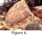
Figure 5). Bedding attitudes near the contact are generally steep, but there is little evidence for structural deformation at the sediment-basement interface. Therefore, the basement has also been tilted to the southeast.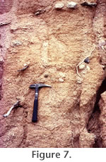 A basal conglomerate, up to a few meters thick is present locally and contains rounded to well-rounded, boulder size clasts, up to 3 m in diameter, of both volcanic and granitic lithologies similar to the local basement (Figure 6). Where the basal conglomerate is absent, it is often difficult to identify the basement contact because the grus developed on the Cameron Granodiorite is very similar to sandstones of Member One. A basal conglomerate, up to a few meters thick is present locally and contains rounded to well-rounded, boulder size clasts, up to 3 m in diameter, of both volcanic and granitic lithologies similar to the local basement (Figure 6). Where the basal conglomerate is absent, it is often difficult to identify the basement contact because the grus developed on the Cameron Granodiorite is very similar to sandstones of Member One.
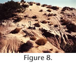 Member One is primarily composed of poorly sorted, poorly to moderately indurated, arkosic sandstone and conglomeratic sandstone. The color of these sediments ranges from gray-tan to reddish-brown depending on the amount of muddy matrix present. Bedding is generally thick, massive, laterally variable, and commonly defined by variability in abundance of pebble-to-cobble size clasts (Figure 7 and
Figure 8). Normally graded beds and trough cross-beds are present locally. Granitic and silicic volcanic clasts are subangular to rounded, pebble to boulder size, and clearly were derived from the nearby Cameron Granodiorite and the Bobtail Quartz Latite. Well-rounded, pebble-to-cobble size clasts of gneiss are very rare. The upper part of Member One fines upward and becomes dominated by tan to brown sandstones and siltstones. Member One is primarily composed of poorly sorted, poorly to moderately indurated, arkosic sandstone and conglomeratic sandstone. The color of these sediments ranges from gray-tan to reddish-brown depending on the amount of muddy matrix present. Bedding is generally thick, massive, laterally variable, and commonly defined by variability in abundance of pebble-to-cobble size clasts (Figure 7 and
Figure 8). Normally graded beds and trough cross-beds are present locally. Granitic and silicic volcanic clasts are subangular to rounded, pebble to boulder size, and clearly were derived from the nearby Cameron Granodiorite and the Bobtail Quartz Latite. Well-rounded, pebble-to-cobble size clasts of gneiss are very rare. The upper part of Member One fines upward and becomes dominated by tan to brown sandstones and siltstones.
 Member Two – Member Two rests conformably on Member One and is equivalent to
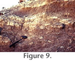
Dibblee's (1958) "Middle Member". The lower contact is marked by a distinct color change from tans and browns below to light grays and white above. In detail, this contact is often gradational over a few meters with thin, gray, calcareous siltstone layers characteristic of Member Two interbedded with brown silt and sandy silt at the top of Member One (Figure 9). Member Two – Member Two rests conformably on Member One and is equivalent to
Dibblee's (1958) "Middle Member". The lower contact is marked by a distinct color change from tans and browns below to light grays and white above. In detail, this contact is often gradational over a few meters with thin, gray, calcareous siltstone layers characteristic of Member Two interbedded with brown silt and sandy silt at the top of Member One (Figure 9).
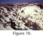 Member Two is the most distinctive member of the Horned Toad Formation because of its relatively resistant nature and its light gray to white color (Figure 10). The outcrop pattern clearly defines the primary structural geometry of the Horned Toad Hills. Fossil mammals representing the Warren Local Fauna were collected primarily from Member Two. Member Two is the most distinctive member of the Horned Toad Formation because of its relatively resistant nature and its light gray to white color (Figure 10). The outcrop pattern clearly defines the primary structural geometry of the Horned Toad Hills. Fossil mammals representing the Warren Local Fauna were collected primarily from Member Two.
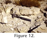
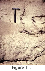 Member Two ranges in thickness from a few meters to a maximum of approximately 25 m (Figure 5). It thins to the southwest and to the northeast. Member Two consists of light gray to white, moderately to well indurated calcareous siltstone, sandy siltstone, sandstone, volcanic tuff, and chert. Thin to thick bedding is distinct, and sedimentary structures include cross-bedding and ripples (Figure 11). The light color of Member Two is the result of abundant carbonate, both as cement and as a primary component of some beds. At least two tuffs are present in Member Two, a lower andesitic tuff that is discontinuous in extent and an upper silicic tuff referred to as the "marker tuff" by
May (1981a) that is more continuous, and has been identified geochemically as the Lawlor Tuff (see discussion below). The "marker tuff" is a 20-40 cm thick, water-lain, airfall deposit composed primarily of glass shards (Figure 12). A secondary detrital component includes rounded quartz grains and a diverse heavy mineral assemblage, including rounded zircons. In the western and central outcrop areas, the "marker tuff" occurs near the top of Member Two; it climbs stratigraphically to the northwest and is present within the green mudstones of Member Three on the north limb of the Warren syncline (Figure 5). Member Two ranges in thickness from a few meters to a maximum of approximately 25 m (Figure 5). It thins to the southwest and to the northeast. Member Two consists of light gray to white, moderately to well indurated calcareous siltstone, sandy siltstone, sandstone, volcanic tuff, and chert. Thin to thick bedding is distinct, and sedimentary structures include cross-bedding and ripples (Figure 11). The light color of Member Two is the result of abundant carbonate, both as cement and as a primary component of some beds. At least two tuffs are present in Member Two, a lower andesitic tuff that is discontinuous in extent and an upper silicic tuff referred to as the "marker tuff" by
May (1981a) that is more continuous, and has been identified geochemically as the Lawlor Tuff (see discussion below). The "marker tuff" is a 20-40 cm thick, water-lain, airfall deposit composed primarily of glass shards (Figure 12). A secondary detrital component includes rounded quartz grains and a diverse heavy mineral assemblage, including rounded zircons. In the western and central outcrop areas, the "marker tuff" occurs near the top of Member Two; it climbs stratigraphically to the northwest and is present within the green mudstones of Member Three on the north limb of the Warren syncline (Figure 5).
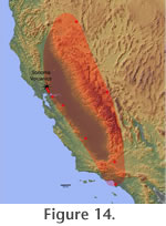
 Recognition of the Lawlor Tuff is important to our age interpretation of the Horned Toad Formation and the Warren Local Fauna. The "marker tuff" was identified as the Lawlor Tuff on the basis of the chemical composition of the volcanic glass (sample HTH-1; A.M. Sarna-Wojcicki, written communication to C. Repenning and S. May 1982). The Lawlor Tuff is a widespread Pliocene tephra layer that was erupted from the Sonoma Volcanics in the central Coast Ranges of California (Sarna-Wojcicki 1971,
1976;
Sarna-Wojcicki et al. 1979). A K-Ar age of ~ 4.0 ± 0.2 Ma, obtained on plagioclase crystals separated from the Lawlor Tuff (Sarna-Wojcicki 1976), was later revised to 4.1 Ma after revision of the 40K decay constant by
Steiger and
Jäger (1977). The Lawlor Tuff was redated in 1994 by A. Deino of the Berkeley Geochronology Center using the 40Ar/39Ar laser-fusion step-heating technique (McLaughlin et al. 2005), and an age of 4.83 ± 0.04 Ma was obtained on multiple individual plagioclase crystals. In the Tassajara Hills, in the central Coast Ranges of California, the Lawlor Tuff is overlain by the Huichica Tuff (4.71 ± 0.03 Ma) (McLaughlin et al. 2005). Recognition of the Lawlor Tuff is important to our age interpretation of the Horned Toad Formation and the Warren Local Fauna. The "marker tuff" was identified as the Lawlor Tuff on the basis of the chemical composition of the volcanic glass (sample HTH-1; A.M. Sarna-Wojcicki, written communication to C. Repenning and S. May 1982). The Lawlor Tuff is a widespread Pliocene tephra layer that was erupted from the Sonoma Volcanics in the central Coast Ranges of California (Sarna-Wojcicki 1971,
1976;
Sarna-Wojcicki et al. 1979). A K-Ar age of ~ 4.0 ± 0.2 Ma, obtained on plagioclase crystals separated from the Lawlor Tuff (Sarna-Wojcicki 1976), was later revised to 4.1 Ma after revision of the 40K decay constant by
Steiger and
Jäger (1977). The Lawlor Tuff was redated in 1994 by A. Deino of the Berkeley Geochronology Center using the 40Ar/39Ar laser-fusion step-heating technique (McLaughlin et al. 2005), and an age of 4.83 ± 0.04 Ma was obtained on multiple individual plagioclase crystals. In the Tassajara Hills, in the central Coast Ranges of California, the Lawlor Tuff is overlain by the Huichica Tuff (4.71 ± 0.03 Ma) (McLaughlin et al. 2005).
In 2006, the original geochemical data from the "marker tuff" were reexamined and additional samples were collected to test the correlation with the Lawlor Tuff. The original sample, HTH-1, collected from the western part of the mapped area, was supplemented by HTH-4, from the central part, and HTH-5, from the eastern part of the area on the north limb of the Warren syncline. In addition, samples of a second tuff, located 14 m stratigraphically below the "marker tuff" (HTH-2 and HTH-3), were collected from the western part of the study area.
Samples HTH-4 and HTH-5 of the "marker tuff", and sample HTH-3 of the underlying tuff from the western part of the study area, were analyzed and their chemical compositions determined. A JEOL 8600 electron microprobe was used to analyze volcanic glass shards separated from the tuffs for nine major and minor elements, which are presented in Table 1, as oxides: SiO2, Al2O3, Fe2O3, MgO, MnO, CaO, TiO2, Na2O, and K2O. The glass shards were separated and cleaned by physical and chemical methods. Relevant laboratory procedures, analytical conditions, and data evaluation techniques used are given in
Sarna-Wojcicki et al. (1984,
2005a) and
Sarna-Wojcicki (2000).
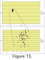 Results of the chemical analysis indicate that samples of the "marker tuff" (HTH-4 and HTH-5) match the previously analyzed HTH-1, as well as the Lawlor Tuff (Table 1; Figure 13). The analyzed samples were compared with over 5600 analyses of tephra samples contained in the U.S. Geological Survey's database of Upper Neogene samples collected from the western USA, Alaska, and Mexico. These data are stored at the U.S. Geological Survey's Tephrochronology Laboratory in Menlo Park, California. Samples HTH-1, 4, and 5 all match, at high similarity coeffiecients, with samples from the Lawlor Tuff collected at its type locality in Lawlor Ravine, in the Los Medanos Hills, in the eastern San Francisco Bay area. Sample LAWLOR-1 is the pumice fall deposit, and LAWLOR-2, the overlying ash-flow unit. Results of the chemical analysis indicate that samples of the "marker tuff" (HTH-4 and HTH-5) match the previously analyzed HTH-1, as well as the Lawlor Tuff (Table 1; Figure 13). The analyzed samples were compared with over 5600 analyses of tephra samples contained in the U.S. Geological Survey's database of Upper Neogene samples collected from the western USA, Alaska, and Mexico. These data are stored at the U.S. Geological Survey's Tephrochronology Laboratory in Menlo Park, California. Samples HTH-1, 4, and 5 all match, at high similarity coeffiecients, with samples from the Lawlor Tuff collected at its type locality in Lawlor Ravine, in the Los Medanos Hills, in the eastern San Francisco Bay area. Sample LAWLOR-1 is the pumice fall deposit, and LAWLOR-2, the overlying ash-flow unit.
 Similarity coefficients are also high when samples HTH-1, 4, and 5 are compared to the average of 43 analyses of well documented samples of the Lawlor Tuff collected from other locations in California, Nevada, and Arizona (Figure 14). Similarity coefficients are well within the range determined for replicate analysis of samples obtained from a single tephra layer. We note that values for sodium and potassium are scattered, an observation that applies to other tephra layers we have analyzed, particularly for older tephra layers, where different parts of the same layer were deposited under different depositional environments, or buried and stored under different climatic or geochemical conditions. For sample, in HTH-5, the iron values are somewhat lower than for most samples of the Lawlor Tuff, and we suspect that some leaching of iron from the glass, as well as hydration and alkali mobility, may have occurred. Similarity coefficients are also high when samples HTH-1, 4, and 5 are compared to the average of 43 analyses of well documented samples of the Lawlor Tuff collected from other locations in California, Nevada, and Arizona (Figure 14). Similarity coefficients are well within the range determined for replicate analysis of samples obtained from a single tephra layer. We note that values for sodium and potassium are scattered, an observation that applies to other tephra layers we have analyzed, particularly for older tephra layers, where different parts of the same layer were deposited under different depositional environments, or buried and stored under different climatic or geochemical conditions. For sample, in HTH-5, the iron values are somewhat lower than for most samples of the Lawlor Tuff, and we suspect that some leaching of iron from the glass, as well as hydration and alkali mobility, may have occurred.
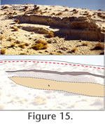 A second tuff was identified and collected during a visit to the Horned Toad Hills in 2006 (HTH-3 in
Table 1). This tuff is darker in color and is discontinuous giving the appearance that it was preserved in local depositional depressions. It is preserved immediately above the most prolific fossil mammal locality in the Horned Toad Formation (RV-7702), where it thickens up to 30-40 cm (Figure 15). This tuff appears to be more andesitic in composition than the Lawlor Tuff, and geochemical results do not match any of the samples in the U.S.G.S. database. It is most similar to a group of andesitic tephra layers erupted from the Cascade Range—for example, samples MSE 202, TWN-L-2.235B, and T2023M.12MYB;2,T187-2 (Table 1). These three samples are derived from the Cascade Range; from Mount Adams, Washington, Tawny Lake, Oregon, and Tule Lake, in northwestern California, respectively. However, all are late Pleistocene and Holocene in age, too young to match the tuff of sample HTH-3. Geochemical identification of the lower tuff in Member Two of the Horned Toad Formation awaits further study. A second tuff was identified and collected during a visit to the Horned Toad Hills in 2006 (HTH-3 in
Table 1). This tuff is darker in color and is discontinuous giving the appearance that it was preserved in local depositional depressions. It is preserved immediately above the most prolific fossil mammal locality in the Horned Toad Formation (RV-7702), where it thickens up to 30-40 cm (Figure 15). This tuff appears to be more andesitic in composition than the Lawlor Tuff, and geochemical results do not match any of the samples in the U.S.G.S. database. It is most similar to a group of andesitic tephra layers erupted from the Cascade Range—for example, samples MSE 202, TWN-L-2.235B, and T2023M.12MYB;2,T187-2 (Table 1). These three samples are derived from the Cascade Range; from Mount Adams, Washington, Tawny Lake, Oregon, and Tule Lake, in northwestern California, respectively. However, all are late Pleistocene and Holocene in age, too young to match the tuff of sample HTH-3. Geochemical identification of the lower tuff in Member Two of the Horned Toad Formation awaits further study.
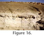 Member Three – This member corresponds to the "Upper Member" of
Dibblee (1958,
1959,
1967) and consists primarily of greenish mudstone, clay, and silty clay. Member Three is exposed on both limbs of the Warren syncline, but thins and eventually pinches out to the southwest in Section 35 (T12N, R13 W, SBBM) (Figure 3 and
Figure 5). The maximum measured thickness is approximately 30 m. Where present, the greenish mudstones of Member Three rest conformably on the light gray to white siltstone and sandy siltstone of Member Two (Figure 16). The upper part of Member Two and the lower part of Member Three are laterally equivalent facies based on their relationship to the Lawlor Tuff (Figure 5). Member Three mudstones weather with a characteristic "popcorn" texture and bedding is indistinct in most outcrops (Figure 17). Member Three – This member corresponds to the "Upper Member" of
Dibblee (1958,
1959,
1967) and consists primarily of greenish mudstone, clay, and silty clay. Member Three is exposed on both limbs of the Warren syncline, but thins and eventually pinches out to the southwest in Section 35 (T12N, R13 W, SBBM) (Figure 3 and
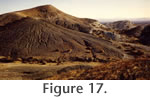
Figure 5). The maximum measured thickness is approximately 30 m. Where present, the greenish mudstones of Member Three rest conformably on the light gray to white siltstone and sandy siltstone of Member Two (Figure 16). The upper part of Member Two and the lower part of Member Three are laterally equivalent facies based on their relationship to the Lawlor Tuff (Figure 5). Member Three mudstones weather with a characteristic "popcorn" texture and bedding is indistinct in most outcrops (Figure 17).
 Member Four – Inclusion of the brown silts and sands of Member Four within the Horned Toad Formation extends the concept of this formation beyond that originally proposed by
Dibblee (1958). Dibblee recognized this lithostratigraphic unit, but considered it to lie unconformably on the Horned Toad Formation and included it in Pleistocene Older Alluvium. Numerous lines of evidence indicate that Member Four is conformable with the underlying units and should be included in the Horned Toad Formation. Member Four – Inclusion of the brown silts and sands of Member Four within the Horned Toad Formation extends the concept of this formation beyond that originally proposed by
Dibblee (1958). Dibblee recognized this lithostratigraphic unit, but considered it to lie unconformably on the Horned Toad Formation and included it in Pleistocene Older Alluvium. Numerous lines of evidence indicate that Member Four is conformable with the underlying units and should be included in the Horned Toad Formation.
The areal extent of Member Four is consistent with the underlying members as are bedding attitudes (Figure 3
and Figure 17).
Dibblee (1967) illustrated an angular discordance between his "sand and silt" unit (= Member Four) and the underlying members of the Horned Toad Formation. He mapped this relationship in the north half of Section 36 (T12N, R13W, SBBM).
Remapping of this area (Figure 3) reveals that the contact, previously
interpreted as an unconformity, is a fault that places southeasterly dipping
strata of Member Four against northwesterly dipping sediments of Member Three.
 The Member Three – Member Four contact is often a gradational color change from green to greenish-brown to brown, accompanied by an increase in the amount of silt and fine sand (Figure 17).
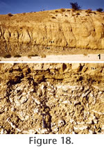
Figure 18 shows an outcrop in which the contact between Members Three and Four is well exposed. At this locality, the base of Member Four is a lenticular channel deposit of fine to very coarse sand approximately 2-3 m thick with internal trough cross bedding and normal graded bedding. The base of this channelform sandstone is a sharp contact with underlying greenish-brown clays of Member Three. These clays exhibit soft sediment deformation features including contorted laminations and convex-up dish structures (Figure 18.2). These features probably were produced by the rapid loading of heavy channel sands on the water-saturated clays. At the margins of the channelform sandstone, the clays of Member Three interfinger with the sand on a very small scale. These relationships document the depositional conformity of Member Four on Member Three and their relative proximity in age. The Member Three – Member Four contact is often a gradational color change from green to greenish-brown to brown, accompanied by an increase in the amount of silt and fine sand (Figure 17).
Figure 18 shows an outcrop in which the contact between Members Three and Four is well exposed. At this locality, the base of Member Four is a lenticular channel deposit of fine to very coarse sand approximately 2-3 m thick with internal trough cross bedding and normal graded bedding. The base of this channelform sandstone is a sharp contact with underlying greenish-brown clays of Member Three. These clays exhibit soft sediment deformation features including contorted laminations and convex-up dish structures (Figure 18.2). These features probably were produced by the rapid loading of heavy channel sands on the water-saturated clays. At the margins of the channelform sandstone, the clays of Member Three interfinger with the sand on a very small scale. These relationships document the depositional conformity of Member Four on Member Three and their relative proximity in age.
Member Four initiates a coarsening upward trend in the Horned Toad Formation with lithologies ranging from silty clay, siltstone, and sandstone at the base to sandstone and pebbly sandstone farther up section. These sediments are poorly indurated, and bedding is generally poorly defined except for thin, indurated beds of coarse sandstone and conglomeratic sandstone. These conglomeratic units of Member Four contain abundant silicic volcanic clasts and lesser amounts of granitic clasts.
 Member Five – As with Member Four, Member Five is a stratigraphic extension of the Horned Toad Formation.
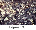
Dibblee (1967) recognized and mapped this lithologic unit, but considered it to belong to Pleistocene Older Alluvium. Our mapping indicates that Member Five lies conformably on Member Four with a gradational contact recognized by an increase in pebble-to-boulder size clasts. Member Five is exposed in the axis of the Warren syncline and along the southeastern edge of the Horned Toad Formation. It has a maximum measured thickness of 90 m and is unconformably overlain by Older Alluvium. Member Five continues the upward coarsening trend established in Member Four. Dominant lithologies include poorly indurated, tan to brown conglomeratic sandstone with indistinct bedding defined by relative clast abundance and rare well-cemented sandstone lenses. Member Five is similar to Member One with poorly sorted arkosic sand matrix and pebble-to-boulder size clasts (Figure 19). However, unlike Member One, 75-85% of the clasts are silicic volcanic lithologies and 15-25% granitoid. This proportion suggests that the Cameron Granodiorite was less important as a source terrain while the volcanic rocks of the Tropico Group (including the Bobtail Quartz Latite) were still providing detritus to the Horned Toad basin. Member Five – As with Member Four, Member Five is a stratigraphic extension of the Horned Toad Formation.
Dibblee (1967) recognized and mapped this lithologic unit, but considered it to belong to Pleistocene Older Alluvium. Our mapping indicates that Member Five lies conformably on Member Four with a gradational contact recognized by an increase in pebble-to-boulder size clasts. Member Five is exposed in the axis of the Warren syncline and along the southeastern edge of the Horned Toad Formation. It has a maximum measured thickness of 90 m and is unconformably overlain by Older Alluvium. Member Five continues the upward coarsening trend established in Member Four. Dominant lithologies include poorly indurated, tan to brown conglomeratic sandstone with indistinct bedding defined by relative clast abundance and rare well-cemented sandstone lenses. Member Five is similar to Member One with poorly sorted arkosic sand matrix and pebble-to-boulder size clasts (Figure 19). However, unlike Member One, 75-85% of the clasts are silicic volcanic lithologies and 15-25% granitoid. This proportion suggests that the Cameron Granodiorite was less important as a source terrain while the volcanic rocks of the Tropico Group (including the Bobtail Quartz Latite) were still providing detritus to the Horned Toad basin.
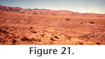
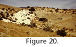 All five members of the Horned Toad Formation are unconformably overlain by unconsolidated sands and gravels assigned to "Older Alluvium" (Figure 3 and
Figure 20). The Older Alluvium defines a remnant surface that has been erosionally dissected by washes that carry Quaternary alluvium (Figure 21). All five members of the Horned Toad Formation are unconformably overlain by unconsolidated sands and gravels assigned to "Older Alluvium" (Figure 3 and
Figure 20). The Older Alluvium defines a remnant surface that has been erosionally dissected by washes that carry Quaternary alluvium (Figure 21).
Depositional Environments
 The Horned Toad Formation is a nonmarine sequence of fluvial and lacustrine sediments deposited on a basement of Cretaceous Cameron Granodiorite and Miocene Gem Hill Formation (Bobtail Quartz Latitie). Members One through Three record a generally fining upward trend followed by a coarsening upward trend in Members Four and Five. Provenance reconstruction of the clast types in Members One, Four, and Five indicate local source terrains to the northwest (Cameron Granodiorite) and south (Gem Hill Formation). Volcanic clasts in the Horned Toad Formation are petrographically indistinguishable from rocks to the southwest and south that are included in the Bobtail Quartz Latite member of the Gem Hill Formation. Granitic clasts can be divided compositionally into granodiorites and granites. Petrographically, these lithologies are very similar mineralogically and texturally to the Cameron Granodiorite (Ross 1989). Sediments of the Horned Toad Formation appear to have been derived locally and can be correlated with source terrains south of the Garlock fault. The Horned Toad Formation is a nonmarine sequence of fluvial and lacustrine sediments deposited on a basement of Cretaceous Cameron Granodiorite and Miocene Gem Hill Formation (Bobtail Quartz Latitie). Members One through Three record a generally fining upward trend followed by a coarsening upward trend in Members Four and Five. Provenance reconstruction of the clast types in Members One, Four, and Five indicate local source terrains to the northwest (Cameron Granodiorite) and south (Gem Hill Formation). Volcanic clasts in the Horned Toad Formation are petrographically indistinguishable from rocks to the southwest and south that are included in the Bobtail Quartz Latite member of the Gem Hill Formation. Granitic clasts can be divided compositionally into granodiorites and granites. Petrographically, these lithologies are very similar mineralogically and texturally to the Cameron Granodiorite (Ross 1989). Sediments of the Horned Toad Formation appear to have been derived locally and can be correlated with source terrains south of the Garlock fault.
The interbedded sandstones and mudstones of Member Two are interpreted as fluvial to lacustrine depositional facies associated with a playa or lakeshore environment that received occasional muddy debris flows at the distal toes of alluvial fans. Channelform, sandy facies with trough cross-bedding and normal grading are interpreted as stream-channel deposits, while lake-plain to lacustrine facies are represented by calcareous siltstones and mudstones. Fossils recovered from Member Two include pond turtle, frog, duck, ostracodes, and diatoms. J.P. Bradbury and R.M. Forester (personal commun., 1981) interpreted the microfossils to reflect near-shore, marshy conditions. Slender root casts are also preserved in siltstones of Member Two. Thin silt and claystone beds, the Lawlor Tuff, and rare cherts were deposited in standing water. Locally, the Lawlor Tuff is stratified with a lower massive interval dominated by glass shards and interpreted as the primary airfall deposit. This is overlain by thinly bedded tuff with local normal grading and an increased abundance of detrital material.
The greenish clays of Member Three record the presence of a permanent lake. As described above and shown in
Figure 5, the Lawlor Tuff is associated with the top of Member Two in the central outcrop area, but climbs stratigraphically into Member Three to the northeast. This indicates that lake margin facies of Member Two are temporally equivalent to the lacustrine facies of Member Three. The facts that the Lawlor Tuff climbs approximately 15 m stratigraphically in less than one mile and that the lacustrine facies of Member Three pinch out abruptly to the southwest suggest a relatively small, steep-margined basin that included transitions from alluvial fan to fluvial to lacustrine depositional environments within a few square miles. The Horned Toad basin may have formed as a small sag basin along the active Garlock fault.
Brown siltstones and sands at the base of Member Four indicate a reversal in the fining upward trend seen in Members One through Three. Members Four and Five record renewed influx of arkosic and volcanic detritus and a basinward shift in facies. Lacustrine and lake margin environments were replaced by fluvial and alluvial fan deposits that ultimately filled the basin. The predominance of Bobtail Quartz Latite clasts in Member Five suggests that the dominant source area for the alluvial fans, during this final phase of basin filling, was to the south and southwest.
Structural History
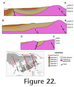 The Horned Toad Formation has been deformed into a series of open folds cut by high angle faults (Figure 3 and
Figure 22). The dominant trend of these structures is southwest-northeast, subparallel to the Garlock fault. As noted above, the Cameron Granodiorite that forms the basement for the Horned Toad sediments is also apparently folded and cut by high angle faults. This structure is evident from the steep southeast dip of the basal contact of the Horned Toad Formation on the granitic basement and by faults exposed in the western Horned Toad Hills. In the northwest quarter of Section 34 (T12N. R13W. SBBM), a well-exposed fault dips approximately 80o to the southeast and exhibits reverse displacement with Cameron Granodiorite on the south juxtaposed against Member One sediments on the north (Figure 22, C-C'). Other faults exposed in Section 5 appear to have normal displacement juxtaposing basement against Member One strata. Along these faults, beds dip at high angles into the basement, and 1-2 m of fault rock (gouge and/or clay smear) is locally visible along the fault traces. The Horned Toad Formation has been deformed into a series of open folds cut by high angle faults (Figure 3 and
Figure 22). The dominant trend of these structures is southwest-northeast, subparallel to the Garlock fault. As noted above, the Cameron Granodiorite that forms the basement for the Horned Toad sediments is also apparently folded and cut by high angle faults. This structure is evident from the steep southeast dip of the basal contact of the Horned Toad Formation on the granitic basement and by faults exposed in the western Horned Toad Hills. In the northwest quarter of Section 34 (T12N. R13W. SBBM), a well-exposed fault dips approximately 80o to the southeast and exhibits reverse displacement with Cameron Granodiorite on the south juxtaposed against Member One sediments on the north (Figure 22, C-C'). Other faults exposed in Section 5 appear to have normal displacement juxtaposing basement against Member One strata. Along these faults, beds dip at high angles into the basement, and 1-2 m of fault rock (gouge and/or clay smear) is locally visible along the fault traces.
May (1981a) presented limited paleomagnetic data from the Cameron Granodiorite along the southeast side of Cameron Ridge that he interpreted as consistent with approximately 50o - 60o of down-to-the-southeast rotation of the basement about a sub-horizontal axis trending sub-parallel to the trace of the Garlock fault. This hypothesis needs to be tested with a more complete sampling and spatial analysis of paleomagnetic data.
The name "Warren Syncline" has occasionally been used as a synonym for the Horned Toad Hills because of the major fold in the northeastern area of exposures (Figure 3). The axis of this syncline trends N50E and plunges gently to the northeast. The entire Horned Toad Formation is exposed on the north limb with bedding attitudes decreasing from 60o southeast near the basal contact. The south limb of the Warren syncline, which generally dips 10o – 20o to the northwest, is itself folded into an anticline and cut by a high-angle reverse fault (Figure 22, A-A'). The main fault in Section 36 (T12N, R13W, SBBM) is roughly axial planar to the anticline, and beds on the south limb exhibit moderately steep (35o – 60o) dips to the southeast and are unconformably overlain by Older Alluvium. Farther northeast along the south limb of the syncline, the reverse fault is apparently offset by an inferred northwest trending fault. Continuing northeast of this structure, the south limb is folded into a southeast vergent, asymmetric anticline with no associated reverse fault at the surface (Figure 3). The faulted south limb of the Warren syncline is interpreted as a fault propagation fold that likely involves basement. As described above, it is the faulted portion of this south-limb anticline that
Dibblee (1967) interpreted as an angular unconformity.
In the central outcrop area (Section 35, T12N, R13W, SBBM), the dominant structure is a southeast dipping, asymmetric anticline (Figure 22, B-B'). This open fold has an axial surface that trends sub-parallel to the trend of the Warren syncline. This gentle anticlinal structure may be laterally equivalent to the fault propagation fold along the south limb of the Warren syncline. It is plausible that the antiform is cored at depth by a basement involved reverse fault. The lateral change from a gentle anticline to a tight, faulted anticline is likely accommodated by northwest trending high-angle faults and secondary folds mapped in the northwest quarter of Section 36 (T12N, R13W, SBBM) (Figure 3). The open anticline plunges gently to the southwest where it is cut by or merges with another high-angle reverse fault that juxtaposes Members Two and Four against Member One.
In summary, the dominant structural style of the Horned Toad Hills is one of southeast vergent, basement involved, fault propagation folds and reverse faults that are exposed at different structural elevations from southwest to northeast (Figure
22). These structures presumably root into the Garlock fault system and were active during the Pliocene to Pleistocene.
Bartley et al. (1990) included the folds in the Horned Toad Formation on their map of Neogene contractional deformation within the Mojave block. Although all of the structures that they show adjacent to the San Andreas and Garlock faults are subparallel to those major structures (and therefore possibly kinematically linked), these authors argue for a regional pattern of north-south shortening that is consistent with slip on the major bounding structures and the northwest trending strike-slip faults within the western Mojave. Whether related to a regional contractional deformation or to local deformation along the Garlock fault, the structural history of the Horned Toad Formation reflects northwest-southeast oriented shortening during the Pliocene to Pleistocene.
Magnetic Polarity Stratigraphy
Paleomagnetic samples were collected from 12 sites in Members Two through Four of the Horned Toad Formation. Three to five separately oriented hand samples were collected at each of six sites in 1980 as described in
May (1981a). At every site, samples were collected from the same bed and separated laterally by no more than 2 m. The initial set of six sites was distributed stratigraphically through 18 m of section in the southeast quarter of Section 35 (T12N, R13W, SBBM). Oriented hand samples were cut to fit into plastic boxes and were measured on an SCT, three-axis, cryogenic magnetometer at the California Institute of Technology. Alternating field (AF) demagnetization was performed with a model GSD-5 Schonstedt specimen demagnetizer.
Stepwise alternating field demagnetization at 5 mT intervals up to 30 mT was performed on all specimens. Higher demagnetization steps up to 70 mT were performed on selected specimens. Natural remanent magnetization (NRM) intensities for 18 specimens ranged from 4.14 x 10⁻⁴ A/m to 1.27 x 10⁻¹ A/m with a mean of 2.04 x 10⁻² A/m. AF demagnetization up to 30 mT generally resulted in a loss of intensity from 30% to 95% of the NRM. Because of a viscous normal component present in most of the primary reversed samples, an initial increase in intensity was often observed.
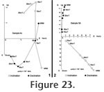 The progressive demagnetization data from all specimens were analyzed with vector demagnetization diagrams (Figure 23). Final directions for each sample were calculated using a least squares regression to an operator designated portion of the demagnetization path. Analysis of the vector demagnetization diagrams indicated stable, primary paleomagnetic directions interpreted as a detrital remanent magnetization (DRM). Within each site, all three samples record the same polarity, but the dispersion was occasionally quite high. Within-site
α95 values ranged from 8o – 102o. The magnetic polarity of each site was interpreted from analysis of the declination and inclination data from each site plotted in a stratigraphic framework. Sites one through four record a lower zone of reversed polarity extending through the lower 13 m of Member Two. Sites four and five exhibit normal polarity extending from the Lawlor Tuff into the base of Member Three at the sampled section. The progressive demagnetization data from all specimens were analyzed with vector demagnetization diagrams (Figure 23). Final directions for each sample were calculated using a least squares regression to an operator designated portion of the demagnetization path. Analysis of the vector demagnetization diagrams indicated stable, primary paleomagnetic directions interpreted as a detrital remanent magnetization (DRM). Within each site, all three samples record the same polarity, but the dispersion was occasionally quite high. Within-site
α95 values ranged from 8o – 102o. The magnetic polarity of each site was interpreted from analysis of the declination and inclination data from each site plotted in a stratigraphic framework. Sites one through four record a lower zone of reversed polarity extending through the lower 13 m of Member Two. Sites four and five exhibit normal polarity extending from the Lawlor Tuff into the base of Member Three at the sampled section.
A second suite of paleomagnetic samples was collected in 2006 to test and extend the original magnetostratigraphic interpretation. Five oriented samples were collected from each of six sites spanning approximately 14 m of section from the upper part of Member Two through the base of Member Four. Most samples consist of siltstone to fine-grained sandstone, and one site was collected from the Lawlor Tuff. Bedding orientations were taken at or near most sites for structural corrections. Samples were cut into 20 mm cubes, then incrementally demagnetized and measured on a 2-G Enterprises cryogenic magnetometer, located in a magnetically shielded room at the Berkeley Geochronology Center. After first measuring the NRM of all samples, they were subjected to alternating field demagnetization at 4, 6, 10, and 12 mT to erase any viscous remanant component. Stepwise thermal demagnetization followed in several steps from 90°C to 600°C using a modified ASC TD-48 thermal specimen demagnetizer.
 Although magnetic polarity was determined for all sampled localities, only three of the six sites (three, four, and five) yielded data from which site mean directions could be calculated (Table 2). The processing was accomplished by averaging a sequential series of thermal demagnetization steps using principal components analysis (Kirschvink 1980), or by selecting a single temperature step considered representative of the mean direction of that sample. Analysis of samples collected at sites one, two, and six, failed to result in a stable linear vector decay toward the origin of the orthogonal vector diagrams on which the demagnetization data were plotted (Figure 24.1). However, polarity determinations for these sites were nonetheless unambiguous, based on the position and trend of the horizontal and vertical components as seen in equal area stereo plots of the data (Figure 24.2,
24.3). Although magnetic polarity was determined for all sampled localities, only three of the six sites (three, four, and five) yielded data from which site mean directions could be calculated (Table 2). The processing was accomplished by averaging a sequential series of thermal demagnetization steps using principal components analysis (Kirschvink 1980), or by selecting a single temperature step considered representative of the mean direction of that sample. Analysis of samples collected at sites one, two, and six, failed to result in a stable linear vector decay toward the origin of the orthogonal vector diagrams on which the demagnetization data were plotted (Figure 24.1). However, polarity determinations for these sites were nonetheless unambiguous, based on the position and trend of the horizontal and vertical components as seen in equal area stereo plots of the data (Figure 24.2,
24.3).
The Lawlor Tuff (site five) was the only site sampled that yielded a "Class 1" normal polarity (Figure 24.4), following
Opdyke et al. (1977) and
Johnson et al. (1982). The five samples analyzed yielded the following mean direction: Dec = 48.2°, Inc = 51.7°, k = 237,
α95 = 5.6° (Table 2). Samples from all other sites yielded reversed paleomagnetic signatures, with only sites three and four allowing calculation of mean directions; they are considered "Class 2" sites. One sample each from sites one and two (of five collected at each site) was suitable for principle components analysis. Results are listed in
Table 2.
The new paleomagnetic data generally confirm the original magnetic polarity zonation of
May (1981a), indicating that the Warren Local Fauna (stratigraphically below the Lawlor Tuff) is from sediments of reversed polarity. The normal polarity of the Lawlor Tuff is confirmed and two of the sites from our 2006 sampling (Site 3, Site 4) extend the original polarity stratigraphy of
May (1981a) higher into Member Three and the base of Member Four. Both of these sites are interpreted as reversed polarity, constraining the normal polarity magnetozone to 3 to 10 m in stratigraphic
thickness.
The following correlation of the Horned Toad Formation magnetostratigraphy is based on the time scale of
Lourens et al. (2004). The basal reversed magnetozone representing most of Member Two is interpreted as Chron 3n.3r (4.896 – 4.997 Ma) primarily based on the recognition of the 4.83 Ma Lawlor Tuff as the lowermost site in the overlying normal polarity zone. The normal polarity magnetozone that includes the Lawlor Tuff is interpreted as Chron 3n.3n (Sidufjall) (4.799 – 4.896 Ma), and the upper reversed polarity magnetozone is interpreted as Chron 3n.2r (4.631 - 4.799 Ma). This correlation relies heavily on the geochemical identification and Ar40/Ar39 age of the Lawlor Tuff and suggests that the age of Member Two of the Horned Toad Formation and the Warren Local Fauna contained therein is approximately 4.85 – 5.0 Ma. Fossils from sites RV-8103, RV-8104, RV-8117, and possibly RV-8124 in Members Three and Four are 4.63 – 4.80 Ma. This correlation differs from that of
May (1981a,
1981b), and
May and Repenning (1982), who interpreted this lower reversed polarity magnetozone as Chron 3An.1r (reversed interval in Chron 5 of earlier terminology).
The mean direction of the "Class 1" normal polarity site five, as seen in
Figure 24.5, indicates that the Horned Toad Hills region has been rotated clockwise about a vertical axis by approximately 48°. Although the data for reversed polarity sites is highly scattered (k = 8.3, alpha95 = 19°), the mean for these sites (Dec = 203.6°, Inc = -56.5°;
Figure 24.5) also indicates clockwise rotation and is within 25° of being antipodal to the normal direction. Discordant paleomagnetic directions implying clockwise rotation of the western Mojave Desert were previously reported by
Golombeck and Brown (1988) who observed modest clockwise rotation (23.8 ±11.3°) in Miocene volcanic rocks southeast of the Horned Toad Hills.
|