| |
INTRODUCTION
Satellite images acquired from a range of different kinds of sensors are now commonly used as sources of data across the geological sciences. Indeed, procedures for the identification and remote analysis of rocks, minerals and tectonic structures have been developed in recent years based on a number of algorithms and approaches (e.g.,' land areas searching for fossil-bearing horizons. However, remote approaches to image data analysis have yet to be widely applied in paleontology.
 In this short paper we demonstrate that even relatively low resolution satellite
image data (in this case derived from Landsat ETM+) can be efficiently and
beneficially used forlow-cost evaluation of geological terrain for
paleontological field exploration. Useful surveys can be made in spite of the
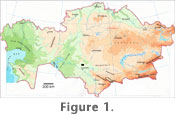
fact that differences between sedimentary lithologies often cannot be discerned from satellite image data alone. The study area for our preliminary analysis is the extensive territory of the Lower Syrdarya Uplift in southern Kazakhstan, an exposed area of more than 17,000 square kilometers increasingly well-known for the preservation of a rich Late Cretaceous fossil vertebrate fauna (e.g.,
Shilin and Suslov 1982;
Nessov 1995;
Kordikova et al. 2001;
Malakhov and Dyke 2003;
Dyke and Malakhov 2004;
Averianov 2007) (Figure 1). On successive field expeditions (2006, 2007) we have analyzed and applied Landsat ETM + image data to guide our prospecting efforts on the ground, saving time and money. In addition to spectral analysis, we have also developed a detailed map of this region based on Landsat image analysis. This approach has made our field logistics very effective, and in particular, allowed us to locate two fresh-water artesian wells in good positions relative to our basic camp for future long-term field work. In this short paper we demonstrate that even relatively low resolution satellite
image data (in this case derived from Landsat ETM+) can be efficiently and
beneficially used forlow-cost evaluation of geological terrain for
paleontological field exploration. Useful surveys can be made in spite of the
fact that differences between sedimentary lithologies often cannot be discerned from satellite image data alone. The study area for our preliminary analysis is the extensive territory of the Lower Syrdarya Uplift in southern Kazakhstan, an exposed area of more than 17,000 square kilometers increasingly well-known for the preservation of a rich Late Cretaceous fossil vertebrate fauna (e.g.,
Shilin and Suslov 1982;
Nessov 1995;
Kordikova et al. 2001;
Malakhov and Dyke 2003;
Dyke and Malakhov 2004;
Averianov 2007) (Figure 1). On successive field expeditions (2006, 2007) we have analyzed and applied Landsat ETM + image data to guide our prospecting efforts on the ground, saving time and money. In addition to spectral analysis, we have also developed a detailed map of this region based on Landsat image analysis. This approach has made our field logistics very effective, and in particular, allowed us to locate two fresh-water artesian wells in good positions relative to our basic camp for future long-term field work.
|