| |
GEOLOGIC SETTING
 Structural evolution during the Phanerozoic was complicated in Iran. The area can be divided into several tectonic provinces based on several structural and sedimentary features (Stocklin 1968;
Eftekharnezhad 1980;
Stampfli 1978;
Berberian and King 1981;
Alavi 1991). One of the most active of these provinces (especially during the Mesozoic and Cenozoic) is central Iran. This tectonic domain formed part of a broad platform through coalescence with other Iranian provinces during the Paleozoic. Prevailing structural patterns mostly include detached tectonic blocks along with major faults. A recent study by
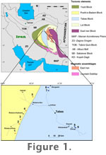
Alavi (1991) has divided central Iran into four blocks including the Lut block (LB), Tabas block (TB), Posht-e-Badam block (PBB) and Yazd block (YB) (Figure 1). The area under study for this paper, Kalmard (West Tabas), is located within the Posht-e-Badam block, which is separated from the Tabas block by the Kalard and Kuhbanan (southern continuation of Kalmard) faults.
Aghanabati (2004) considered the Kalmard area part of the Tabas block based on a strong resemblance between the Precambrian basement in the Kalmard and Tabas areas. He also proposed that since the Kalmard area is situated between two active faults (Kalmard fault in the East and the covered Naeini fault in the West) it is possible to designate this area as an isolated sub-block within Tabas. The oldest rocks in Kalmard are the Kalmard Formation of Precambrian age. They are well folded and overlain by the Ordovician Shirgesht Formation, separated by an angular unconformity. The Ordovician-Middle Triassic strata in the Kalmard area were deposited in a shallow water platform that possesses lithologic dissimilarities with the Tabas area. There is no report of upper Triassic sediments in the Kalmard area, which would be indicative of a longer hiatus than in the Tabas area resulting from early Kimmerian orogeny (Aghanabati 2004). Structural evolution during the Phanerozoic was complicated in Iran. The area can be divided into several tectonic provinces based on several structural and sedimentary features (Stocklin 1968;
Eftekharnezhad 1980;
Stampfli 1978;
Berberian and King 1981;
Alavi 1991). One of the most active of these provinces (especially during the Mesozoic and Cenozoic) is central Iran. This tectonic domain formed part of a broad platform through coalescence with other Iranian provinces during the Paleozoic. Prevailing structural patterns mostly include detached tectonic blocks along with major faults. A recent study by
Alavi (1991) has divided central Iran into four blocks including the Lut block (LB), Tabas block (TB), Posht-e-Badam block (PBB) and Yazd block (YB) (Figure 1). The area under study for this paper, Kalmard (West Tabas), is located within the Posht-e-Badam block, which is separated from the Tabas block by the Kalard and Kuhbanan (southern continuation of Kalmard) faults.
Aghanabati (2004) considered the Kalmard area part of the Tabas block based on a strong resemblance between the Precambrian basement in the Kalmard and Tabas areas. He also proposed that since the Kalmard area is situated between two active faults (Kalmard fault in the East and the covered Naeini fault in the West) it is possible to designate this area as an isolated sub-block within Tabas. The oldest rocks in Kalmard are the Kalmard Formation of Precambrian age. They are well folded and overlain by the Ordovician Shirgesht Formation, separated by an angular unconformity. The Ordovician-Middle Triassic strata in the Kalmard area were deposited in a shallow water platform that possesses lithologic dissimilarities with the Tabas area. There is no report of upper Triassic sediments in the Kalmard area, which would be indicative of a longer hiatus than in the Tabas area resulting from early Kimmerian orogeny (Aghanabati 2004).
|