| |
INTRODUCTION
The Glen Rose Formation represents the transgression phase of a transgressive-regressive sequence within the Lower Cretaceous Trinity Group (Upper Aptian – Lower Albian) of Central Texas (Jacobs and Winkler 1998). The Glen Rose Formation, and indeed the entire Trinity Group, preserves a diverse vertebrate fauna represented by body fossils (Winkler et al. 1990). At the type locality in Somervell County, Texas, the Glen Rose Formation is approximately 75 m thick and is considered earliest Albian in age (Rodgers 1967,
Young 1967,
Perkins 1987,
Winkler et al., 1989,
Jacobs and Winkler 1998). The Glen Rose Formation is subdivided into three members. The upper member consists of alternating limestones and marls. The middle member is the most extensive unit, consisting of lime mudstones, wackestones, and calcarenites. The lower member consists of alternating arenaceous limestones and mudstones (Winkler
et al., 1989). Sediments in the lower member formed on shallow subtidal to tidal flats (Hawthorne 1990), preserving extensive tracks of theropods and sauropods, as well as rare ornithopod tracks (Farlow 1987,
Pittman 1989,
Hawthorne 1990).
 Since their discovery in the early part of the 20th Century, dinosaur tracks have been an integral part of the human as well as geological history of North Central Texas (Bird 1985,
Jacobs 1997,
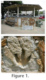
Jasinski 2008). In 1935, Shuler formally described the large theropod track embedded in the stone wall of the bandstand in the Somervell County Courthouse square in Glen Rose, Texas.
Shuler (1935) tentatively assigned it to the ichnogenus Eubrontes (?) as a new ichnospecies Eubrontes (?) glenrosensis (Figure 1.1,
Shuler 1935,
Albritton 1942,
Langston 1974,
Farlow 1987). The specimen was originally from the "fourth crossing" (Hendrix-Ramfield crossing) of the Paluxy River, that now lies in Dinosaur Valley State Park, approximately 6 miles west of the town of Glen Rose (Shuler 1935,
Jasinski 2008). As a type specimen, conservation is important, but in this case less than optimum. The footprint, preserved as an impression in limestone (Figure 1.2), is exposed to weather and has suffered visible erosion. However, given the cultural and historical significance of the specimen, removal to an institutional collection is not feasible. Therefore, our goals were to: (1) preserve the current state of the track surface as a 3D facsimile for archive and conservation, (2) provide a baseline for study of future erosional damage, and (3) provide a low cost, accessible method of distribution for study and outreach. Since their discovery in the early part of the 20th Century, dinosaur tracks have been an integral part of the human as well as geological history of North Central Texas (Bird 1985,
Jacobs 1997,
Jasinski 2008). In 1935, Shuler formally described the large theropod track embedded in the stone wall of the bandstand in the Somervell County Courthouse square in Glen Rose, Texas.
Shuler (1935) tentatively assigned it to the ichnogenus Eubrontes (?) as a new ichnospecies Eubrontes (?) glenrosensis (Figure 1.1,
Shuler 1935,
Albritton 1942,
Langston 1974,
Farlow 1987). The specimen was originally from the "fourth crossing" (Hendrix-Ramfield crossing) of the Paluxy River, that now lies in Dinosaur Valley State Park, approximately 6 miles west of the town of Glen Rose (Shuler 1935,
Jasinski 2008). As a type specimen, conservation is important, but in this case less than optimum. The footprint, preserved as an impression in limestone (Figure 1.2), is exposed to weather and has suffered visible erosion. However, given the cultural and historical significance of the specimen, removal to an institutional collection is not feasible. Therefore, our goals were to: (1) preserve the current state of the track surface as a 3D facsimile for archive and conservation, (2) provide a baseline for study of future erosional damage, and (3) provide a low cost, accessible method of distribution for study and outreach.
|