FIGURE 1. Geographic sketch showing the location of the plant-bearing sites. For locality numbers see Table 1.
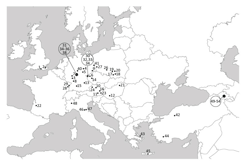
FIGURE 2. Modern vegetation types/formations delivered as proxies by Drudges 1 and 2 for the test set of fossil assemblages. Shown are the five best fitted results for the IPR Similarities based on Drudge 1 and Drudge 2 and for the Results Mix based on Drudge 1 and Drudge 2. Pastel colours represent East Asian vegetation types, bright colours European vegetation formations. For more detailed information see Appendix 4 which provides interactive colour signature (moving the cursor over the columns provides the designation of the proxies and their relevance for every fossil assemblage).
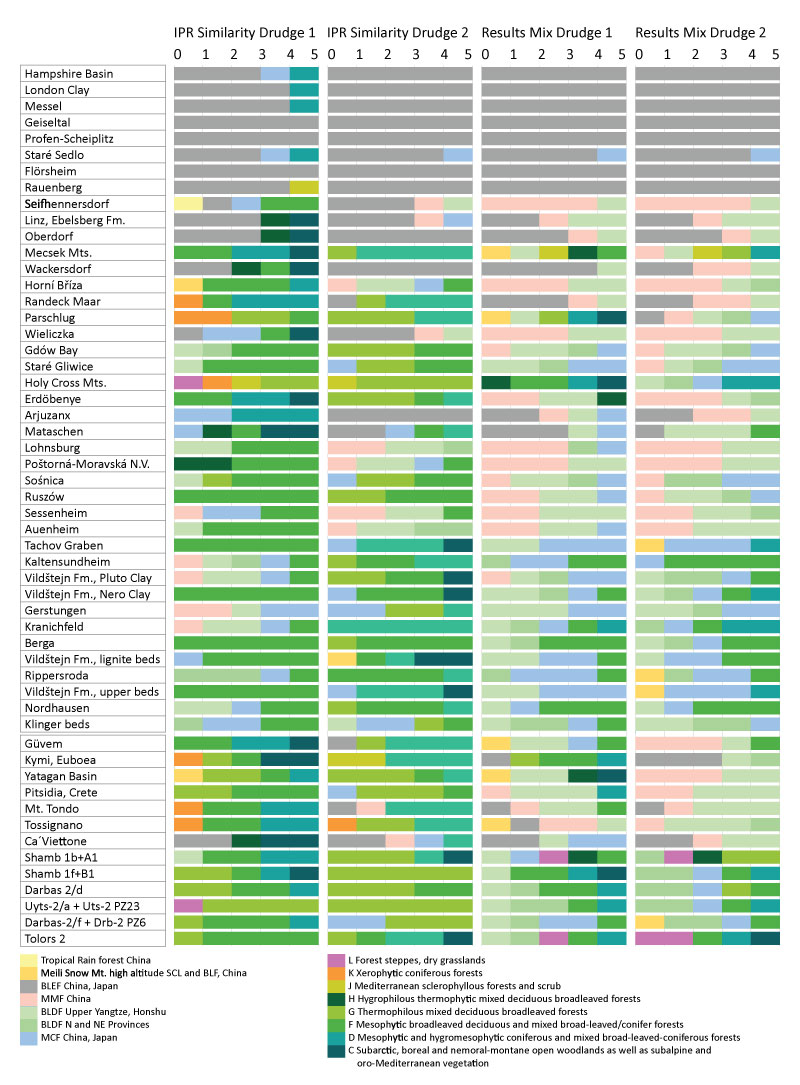
FIGURE 3. Modern vegetation types/formations delivered as proxies by Drudges 1 and 2 for the test set of fossil assemblages. Shown are the five best fitted results for the Taxonomic Similarity (TS) and the overall scores (synthesis of all similarity approaches), i.e., 25 proxies for every plant assemblage. Pastel colours represent East Asian vegetation types, bright colours European vegetation formations. For more detailed information see Appendix 4 which provides interactive colour signature (moving the cursor over the columns provides the designation of the proxies and their relevance for every fossil assemblage).
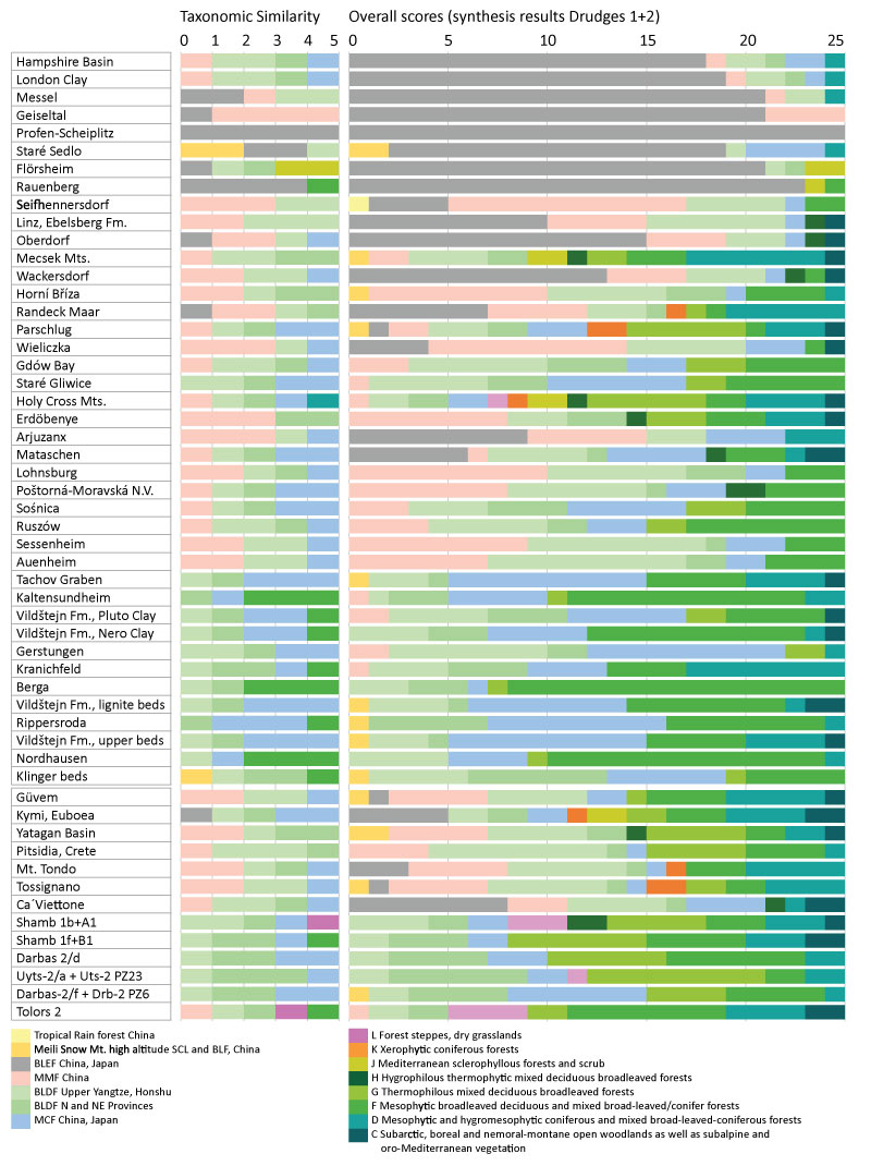
FIGURE 4. Representation of East Asian and European vegetation types and formations as delivered by Drudges 1 and Drudge 2 for the IPR Similarity, Taxonomic Similarity (TS), and Results Mix. See also Appendix 8.
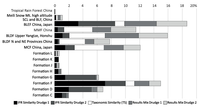
FIGURE 5. Representation of modern East Asian vegetation types for the test set of fossil assemblages as delivered by Drudges 1 and 2. More detailed information on units is available in Appendix 9.
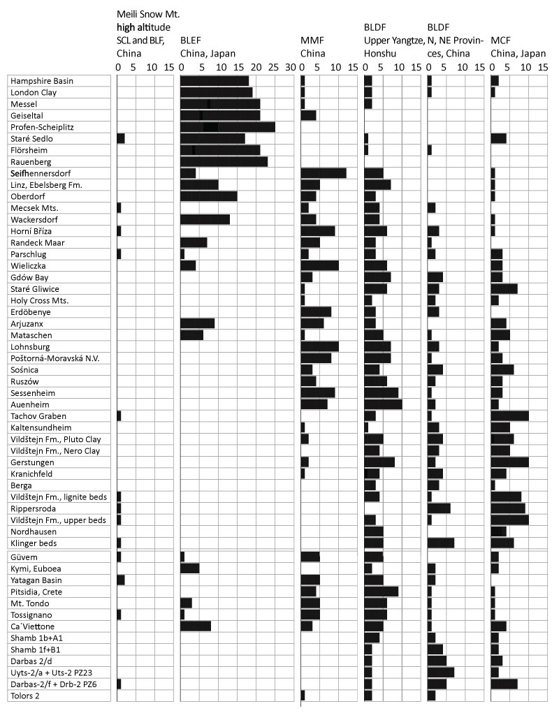
FIGURE 6. Representation of modern European vegetation formations for the test set of fossil assemblages as delivered by Drudges 1 and 2. Formation H - Hygrophilous thermophytic mixed deciduous broadleaved forests; Formation G - Thermophilous mixed deciduous broadleaved forests; Formation F - Mesophytic broadleaved deciduous and mixed broadleaved/conifer forests; Formation D - Mesophytic and hygromesophytic coniferous and mixed broadleaved-coniferous forests; Formation C - Subarctic, boreal and nemoral-montane open woodlands as well as subalpine and oro-Mediterranean vegetation. More detailed information on subdivisions and units is available in Appendix 9.
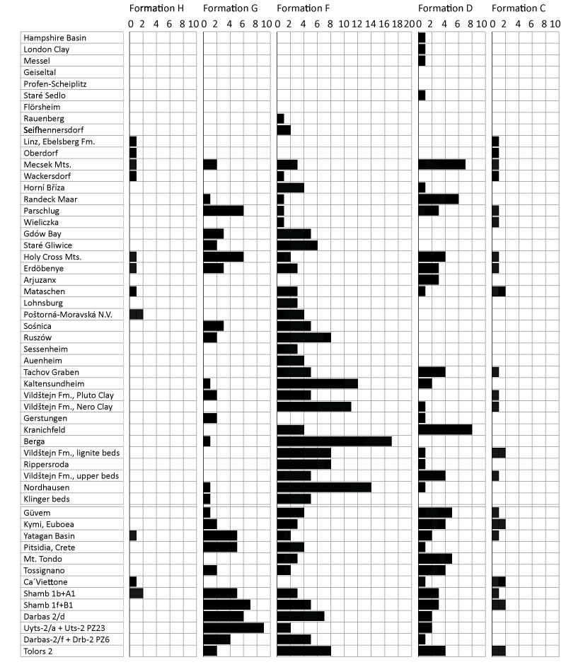
FIGURE 7. Representation of modern European vegetation formations for the test set of fossil assemblages as delivered by Drudges 1 and 2 in more detail (see also Appendix 9).
Formation H: H001, Colchic lowland to submontane mixed oak forests, in black; H002, Hyrcanian lowland-colline mixed broadleaved forests, in dark grey; H003, Hyrcanian colline to montane oak forests, in light grey.
Formation G: G.1 - Subcontinental thermophilous (mixed) pedunculate oak and sessile oak forests, in black; G.2 - Sub-Mediterranean-subcontinental thermophilous bitter oak and Balkan oak and mixed forests, in dark grey; G.3 - Sub-Mediterranean and meso-supra-Mediterranean downy oak and mixed forests, in light grey; G.4 - Iberian supra- and meso-Mediterranean oak forests, in white.
Formation F: F.1 - Species-poor acidophilous oak and mixed oak forests, in black; F.2 - Mixed oak-ash forests, in dark grey; F.3 - Mixed oak-hornbeam forests, in light grey; F.4 Lime-pedunculate oak forests, in white; F.5 - Beech and mixed beech forests, hatched lower left to upper right; F.6 - Oriental beech forests and hornbeam-oriental beech forests, hatched upper left to lower right; F.7 - Caucasian mixed hornbeam-oak forests, hatched vertically.
Formation F, F.5 - Beech and mixed beech forests: F.5.1.1 - Species-poor oligotrophic to mesotrophic beech and mixed beech forests, lowland(-colline) types, in black; F.5.1.2 - Species-poor oligotrophic to mesotrophic beech and mixed beech forests, colline-submontane types, in dark grey; F.5.1.3 - Species-poor oligotrophic to mesotrophic beech and mixed beech forests, montane-altimontane types, in light grey; F.5.2.1 - Species-rich eutrophic and eu-mesotrophic beech and mixed beech forests, colline-submontane types, in white; F.5.2.2 - Species-rich eutrophic and eu-mesotrophic beech and mixed beech forests, colline-submontane types, hatched lower left to upper right; F.5.2.3 and 4 - Species-rich eutrophic and eu-mesotrophic beech and mixed beech forests, montane-altimontane types, hatched upper left to lower right.
Formation D: D.1 - Western boreal spruce forests, in black; D.2 - Eastern boreal pine-spruce and fir-spruce forests, in dark grey; D.3 - Hemiboreal spruce and fir-spruce forests with broad-leaved trees, in light grey; D.4 - Montane to altimontane, partly submontane fir and spruce forests in the nemoral zone, in white; D.5 - Boreal and hemiboreal pine forests, hatched lower left to upper right; D.6 - Montane to altimontane (subalpine) pine forests in the nemoral zone; hatched upper left to lower right.
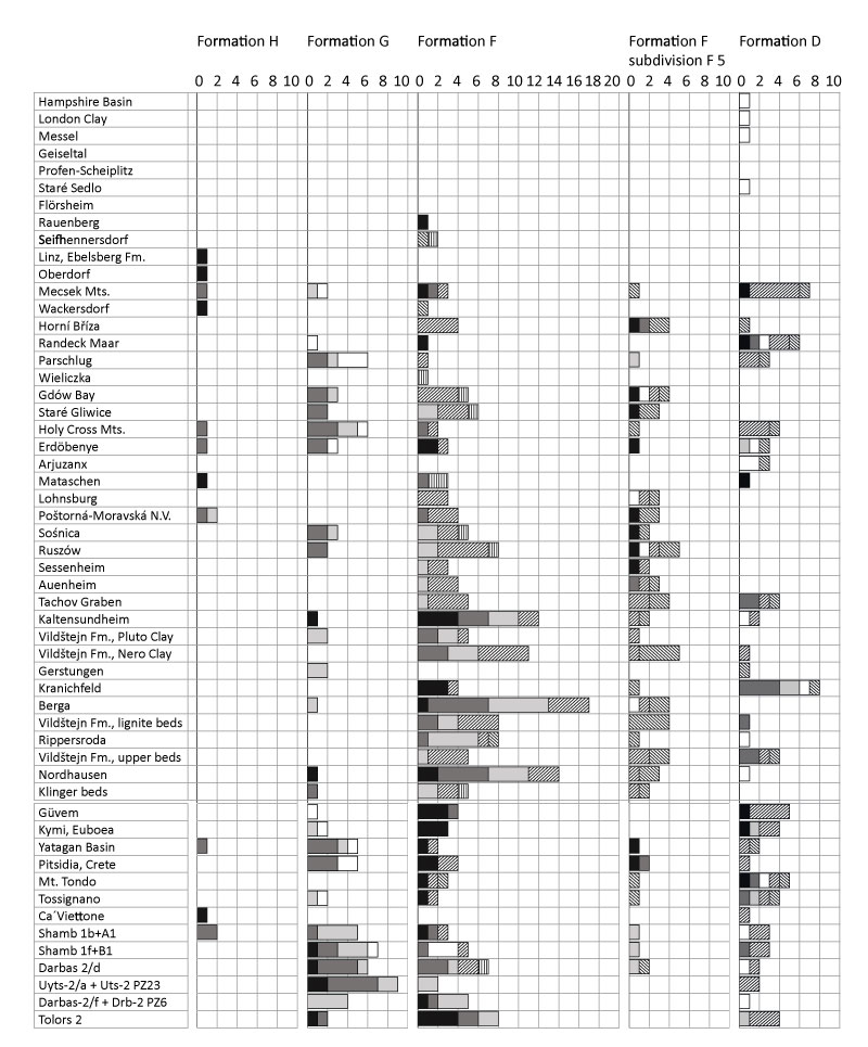
FIGURE 8. Mean annual temperature (MAT), warm-month mean temperature (WMMT), and cold-month mean temperature (CMMT) based on CLAMP and the Coexistence Approach (CA) for the fossil plant record (sources are Kvaček et al., 2011; Teodoridis and Kvaček, 2015; Teodoridis et al., 2009, 2012, 2015, 2017). black columns: minimum CA. light grey columns: maximum CA, narrow, dark grey columns: CLAMP result. For more comprehensive climate data see Appendix 10.
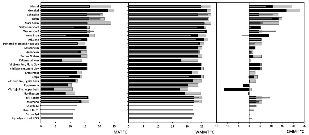
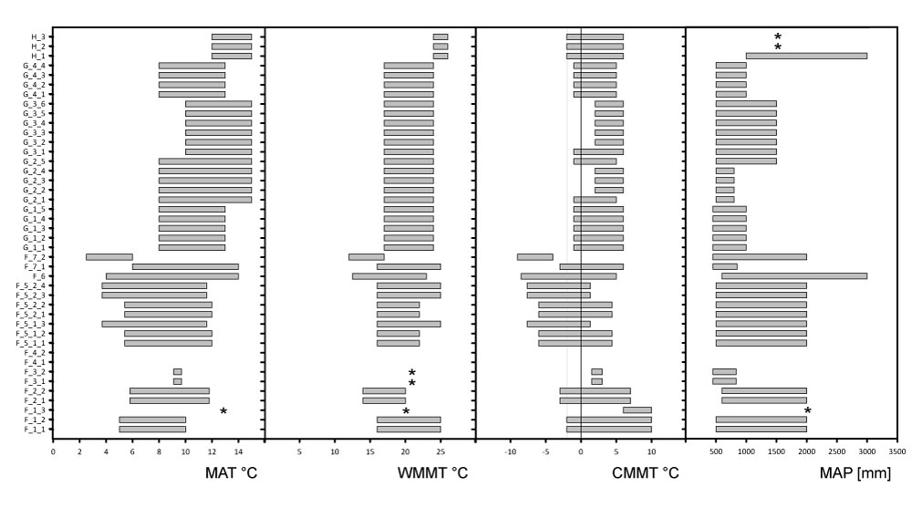
FIGURE 9. Climate parameters of the modern European vegetation Formations F, G, and H based on Bohn et al. (2004) and Traiser and Mosbrugger (2004) represented as columns spanning the minimum and maximum of the respective data. Vegetation of Formation F tends to lower temperatures (note, however, that climate data for formations F.3 - F.1 are more complex). Vegetation of Formation G tends to lower MAP. Asterisks indicate single data points (no climate interval was available). The data are listed in Appendix 11. Abbreviations: MAT = mean annual temperature; WMMT = warm-month mean temperature; CMMT = cold-month mean temperature; MAP = mean annual precipitation.