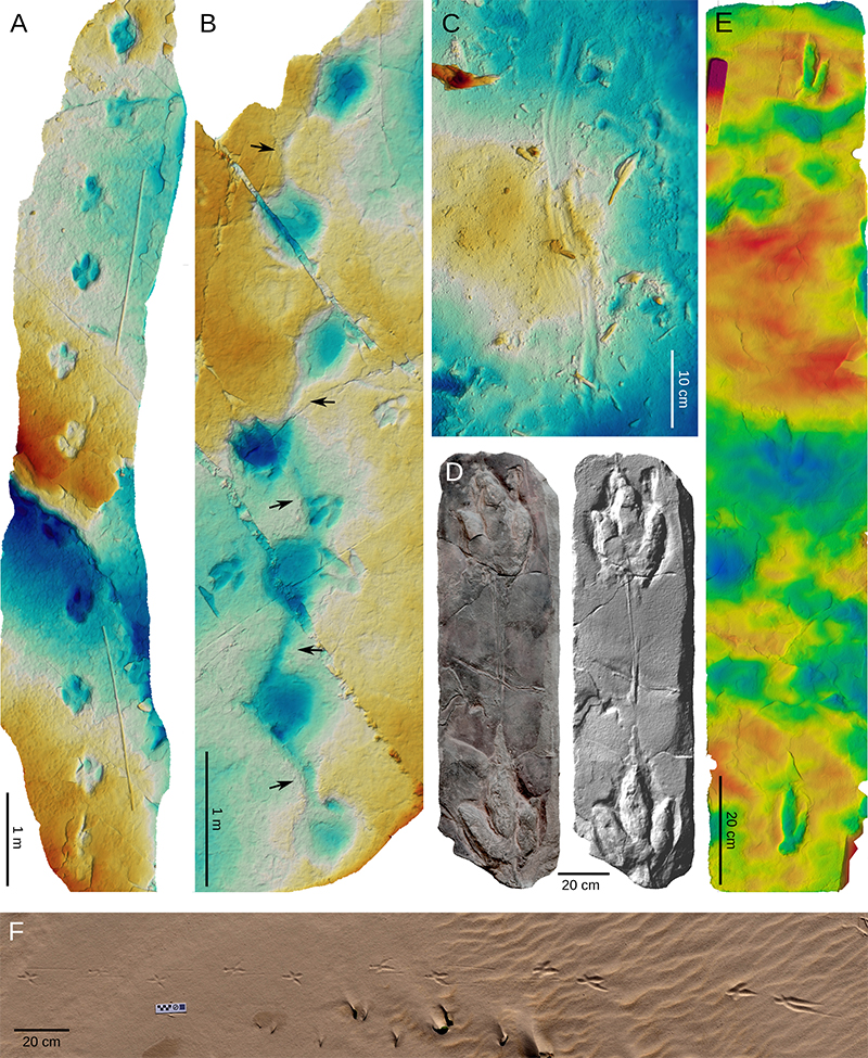
FIGURE 1. Structures that are not tetrapod tracks but have repeatedly been mistaken for such. A, Limulid trackway referred to Kouphichnium, from the Upper Triassic Yanchang Group, Shaanxi, China (Xing et al., 2024). Photo by Lida Xing. B, Probable fish feeding traces (modern), Wales (Lallensack et al., 2022c). C, Weathering pits from the Jurassic of Mibladen, Morocco. D, Elevation maps of weathering pits from the Maastrichtian Irbzer Formation, Middle Atlas, Morocco; note the superficial resemblance to dinosaur tracks.
FIGURE 2. Discrete element simulation of the formation of a penetrative track in a layered sediment, in side and front views. The simulation was performed with the open-source software LIGGGHTS (Kloss and Goniva, 2011). A, The modelled foot at touch-down. B, As the foot reaches the deepest point, it penetrated four layers, forming a total of four penetrative tracks as well as one transmitted undertrack on the deepest layer. C, Terminology demonstrated on the freshly made track that consists of five track surfaces (the surface track, three penetrative undertracks, and one transmitted undertrack). The direct track (red rectangle) differs from the true track in that it includes only those grains that were in direct contact with the foot, rather than entire lateral extent of the track.
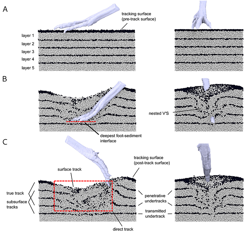
FIGURE 3. Six different 2D-visualizations of a single theropod track (Copper Ridge tracksite; Upper Jurassic, Morrison Formation, Utah, US). A, Orthophoto. B, Elevation map using multiple distinct colours as well as shading by low-angled artificial light. C, Elevation map without additional shading, with warm colours restricted to the lower third of the total depth, emphasizing features of the track floor (note that here, dark red marks the deepest areas). D, Contour plot using 100 contours; the contour interval is 1.29 mm. E, Inclination map with additional shading using low-angled light. F, Ambient occlusion plot. The total depth of the model is 12.9 cm.
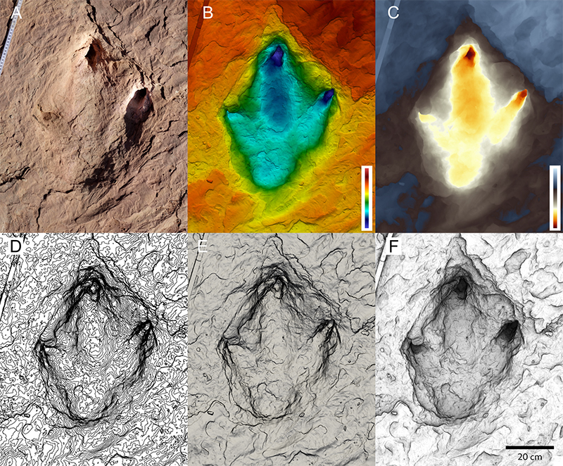
FIGURE 4. Data collection in the field. A, Mapping tracks on the steeply inclined surface of the Cal Orck’o tracksite (El Molino Formation, Sucre, Bolivia), showing Giuseppe Leonardi in the expedition of Christian Meyer and team in 1998. Mapping steep surfaces remains a challenge but is now facilitated with the use of drones. B, A freshly made latex cast of a theropod track, at Quondong beach, Dampier Peninsula, Western Australia, in 1997. From left to right: Tony Thulborn, Giuseppe Leonardi, Tim Halley. C, Martin Lockley tracing the outline of a theropod track on transparent foil in 2011, Obernkirchen Sandstone, Lower Cretaceous, Germany. D, Field crew preparing dinosaur trackways for removal from an active quarry in 2009 at Münchehagen (Obernkirchen Sandstone, Lower Cretaceous, Germany). Photograph by Oliver Wings. E, Peter Falkingham collecting photographs for photogrammetry of a sauropod trackway at Ardley Quarry (Middle Jurassic, England).
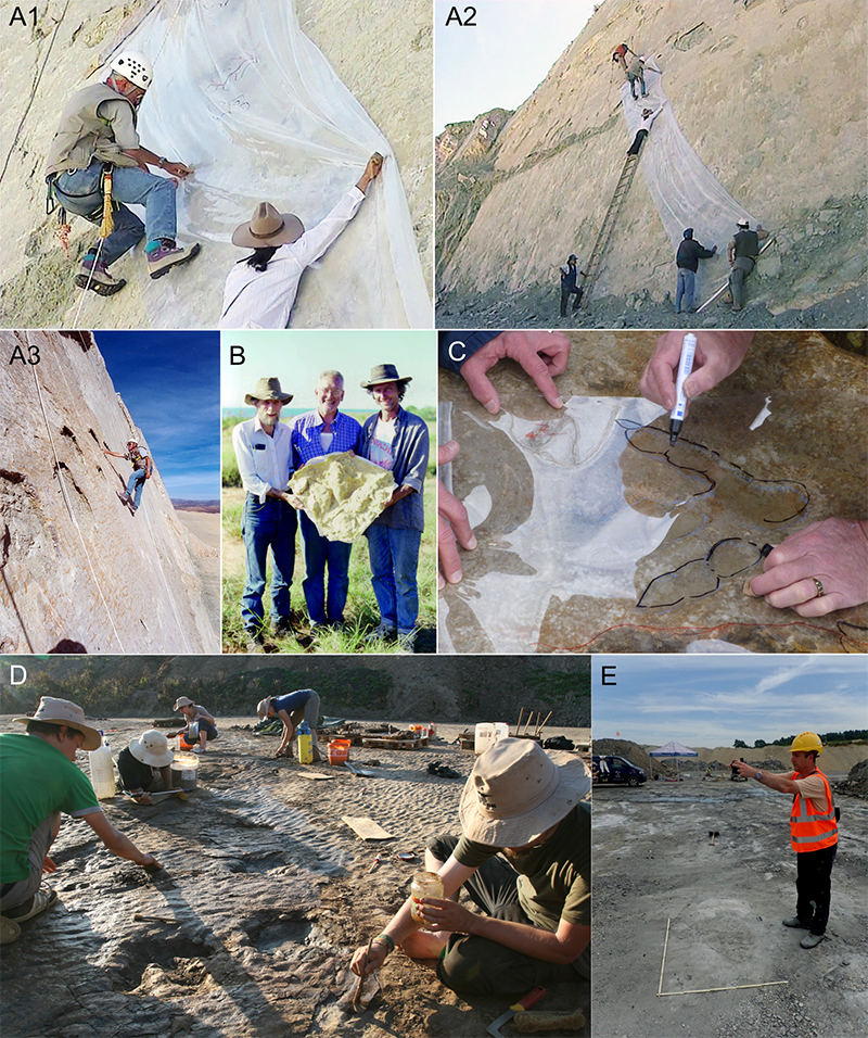
FIGURE 5. Post-formational alteration of tracks. A, Wind erosion of a freshly-made human trackway in moist sand, Liverpool, UK. Three stages show the transition from the freshly made trackway (top) to the increasingly unrecognisable trackway after wind erosion (bottom), separated in time by 8 minutes. Left: Orthophotos; right: elevation maps. B, Elevation map showing recent erosion of a Lower Cretaceous theropod track by river flow (towards the bottom right), bed of the Paluxy River (Glen Rose Formation, Texas, US). C, The theoretical effects of shearing during diagenesis on a sauropod trackway. Left, undeformed trackway; right, trackway after deformation. The lines indicate the paces of the pes tracks. Note the reduced stride lengths and the pronounced differences between the right and left step lengths that give the impression of a “limp”. Redrawn after Schulp and Brokx (1999). D, Sauropod trackway with manus tracks (M) deformed by the pes, Tafaytour tracksite (Jurassic, Morocco) (Lallensack et al., 2019). Note that the labelled tracks (“elite tracks” in the original meaning of the term) are overprinting numerous incomplete and indistinct tracks (“background trampling”). E, Fake claw marks added to the real track of a theropod (Arizona, US).
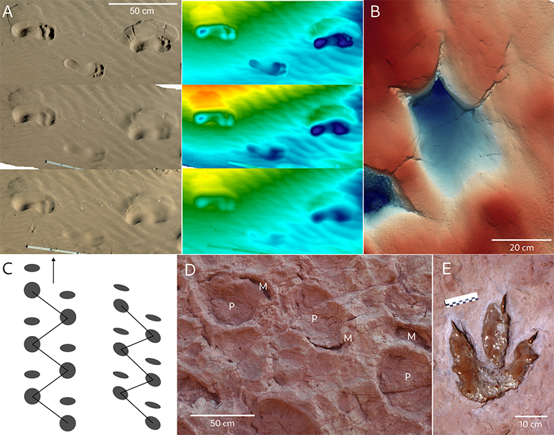
FIGURE 6. Natural moulds and natural casts. A, Natural casts of theropod tracks on the underside of a cliff overhang, Teyateyaneng tracksite (Lower Jurassic, Lesotho; light from left). Photo: Oliver Wings. B, Ex-situ natural cast of an ornithopod track on a beach at Hanover point (Lower Cretaceous, Isle of Wight, England). C, deep track of a theropod showing “toe tunnels” caused by the collapse of sediment above the digits (Paluxy Riverbed, Lower Cretaceous, Glen Rose Formation, Texas, US). D, Elevation map of a sauropod trackway with infilled manus tracks or “plugs” (Jurassic, Isli Formation, Imilchil, Morocco), with blue indicating low elevations and red heigh elevations (Oukassou et al., 2019).
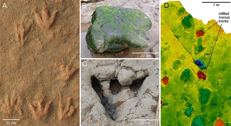
FIGURE 7. Examples of fossil and recent tracks. A, Natural cast of a tetradactyl track attributed to a ceratopsid, from a coal mine near Price, Utah (Upper Cretaceous; Blackhawk Formation; specimen on exhibit at the USU Eastern Prehistoric Museum, Price). Note the metatarsal mark. The length of the track is ca. 43 cm. B, Natural cast of a fidelitous track of a small theropod from the Hitchcock collection, Beneski Museum of Natural History (on slab ACM-ICH 4/1; Lower Jurassic, Connecticut Valley, US). Also note the raindrop impressions in the upper right. Length of track: 15.4 cm. C, Elevation map of a manus-pes set of a sauropod from the Upper Triassic of Greenland (Fleming Fjord Formation; Lallensack et al., 2017). Note the impressions of the medial sides of the four laterally deflected claws of the pes, indicating plantarflexion. D, Modern track of the left foot of a carrion crow (Corvus corone), Liverpool, England. Note the hallux claw mark that is strongly elongated due to dragging; also note the drag marks (“smear marks”) associated with digit IV, and a narrow drag mark on the right left by the right foot. E, Elevation map of palmate tracks of modern seagulls (Larus sp.), Prestatyn, Wales. Note the impressions of the interdigital webs and the associated raindrop impressions. F, Shallow tracks of a modern Tayra (Eira barbara; Serra do Gandarela National Park, Minas Gerais, Brazil), showing a pes overprinting parts of the manus. Left: Orthophoto, right: elevation map. G, Deep track of a modern South American Tapir (Tapirus terrestris), Manu National Park, Peru. H, Two tracks of trackway tr31, Dinosaur State Park, Rocky Hill (Lower Jurassic; East Berlin Formation; Connecticut, US). Note that the tracks are exposed on different layers, with the first track probably representing a transmitted undertrack. I-J, Elevation maps of penetrative theropod tracks formed by deep sinking of the feet, El Frontal tracksite, La Rioja, Spain (Lower Cretaceous, Huérteles Formation; Razzolini et al., 2014). I, Trackway showing the typical morphology of penetrative tracks with slit-like digit impressions due to sediment collapse, curved digit impressions II and IV, metatarsal marks; and hallux impressions. J, Penetrative tracks with collapsed digit impressions, resulting in a triangular shape. K, Elevation map of deep tracks of a theropod, Barranco de Valdecevillo, La Rioja, Spain (Trackway VA4, Enciso Group; Pérez-Lorente, 2015). Note the narrow digit impressions due to sediment collapse. L, Elevation map of a track of trackway SPMN-JTP 3, from the Upper Cretaceous of Jordan (Klein et al., 2020). Note the strongly elongated metatarsal mark. M, Photograph of Rhynchosauroides track NML-G 2022/0001 from the Middle Triassic of Bernburg, Germany (collection Frank Trostheide, Naturkundemuseum Leipzig). Note the well-defined skin impressions.
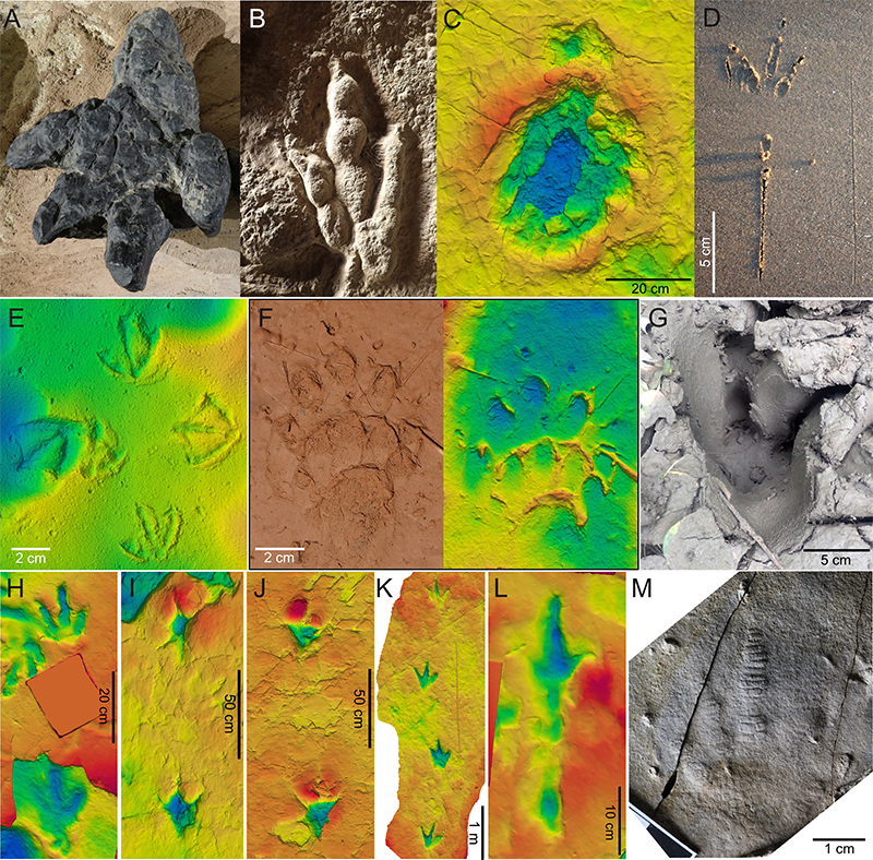
FIGURE 8. Examples of fossil trackways. A, Two parallel sauropod trackways at Cal Orck’o in 1998 (El Molino Formation, Sucre, Bolivia). The shown trackways are ca. 100 m in length. B, Trackway attributed to a giant sloth (Megatherichnum oportoi), from the Pliocene of Argentina (Río Negro Formation). Width of the trackway is ~ 1 m. C, Trackway of a human (Homo sp.) descending a slope on a pyroclastic flow while leaving slip marks (Middle Pleistocene, Roccamonfina volcanic complex, Italy). D, Trackway attributed to an ornithopod (the holotype of Sousaichnium pricei), from the Lower Cretaceous Sousa Formation (Passagem das Pedras, Paraíba, Brazil) (Leonardi, 1979). E, Sauropod trackway with extensive displacement rims (Paluxy Riverbed, Lower Cretaceous, Glen Rose Formation, Texas, US). The scale bar in the centre of the photograph is 1 m. Photo by James O. Farlow. F, Chirotherium barthii trackway, Goldfuß-Museum (Middle Triassic, Hildburghausen, Germany). Note the prominent desiccation cracks. G, Otozoum trackway (large tracks) associated with numerous small theropod tracks from the Hitchcock collection, Beneski Museum of Natural History (part of specimen 6A/2; Lower Jurassic, Connecticut Valley, US). H, Large theropod trackway with a distinct metatarsophalangeal pad, Peñaportillo (Lower Cretaceous, Upper Enciso Group, La Rioja, Spain).
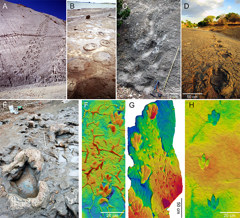
FIGURE 9. Palaeoecological interpretations of tracksites. A, Part of the Mill Canyon tracksite, Utah, US (Upper Jurassic; Cedar Mountain Formation), showing small and large theropod tracks and a manus-only sauropod trackway (direction of travel to the right). This site shows a particularly diverse trace fossil assemblage, including tracks of ornithopods, different types of theropods, sauropods, and possible crocodylomorphs (Lockley et al., 2014). Also note the warty surface texture, which resulted from the growth of a microbial mat (Pustularichnus; Simpson et al., 2022). The view shown is ca. 2.2 m in width. B, The main section of the El Contadero tracksite, La Rioja, Spain (Lower Cretaceous, Enciso Group). The preserved ornithopod tracks vary from being deep with pronounced displacement rims to shallow with low displacement rims. This variation could be explained by spatial differences in substrate properties, in which case they could have been left by a single group (Pérez-Lorente, 2015). Alternatively, the tracksite could be time-averaged, with the shallow tracks formed when the substrate was firm, and the deeper tracks formed when it was soft.
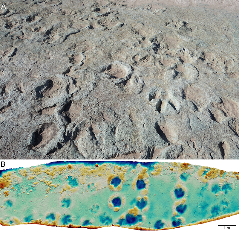
FIGURE 10. Interpreting behaviour from tracks. A, The Fuentesalvo tracksite (Lower Cretaceous; Villar del Río, Soria, Spain), which has been interpreted as evidence for gregarious behaviour. The trackmakers have originally been identified as theropods (Barco et al., 2006), but an ornithopod affinity was subsequently suggested (Castanera et al., 2013). B, Highly tortuous trackway of a modern shorebird, possibly Common Redshank (Tringa totanus), that was searching a tidal flat for food (Liverpool, England). C, Turning trackway of a sauropod at Copper Ridge, Utah (Upper Jurassic; Morrison Formation). Elevation map based on a 3D model captured in 2016. D-E, Elevation maps of swimming tracks at the Inzar O’Founass tracksite, Morocco (Middle Jurassic, El Mers I Formation; Amzil et al., 2024). D, scratch mark of a theropod that might have been made during punting; note the three sub-parallel scratches and the posterior sediment mound. E, Hatcherichnus track (possibly crocodylomorph) with pronounced striations and sediment mound. F, Interpretative map of a section of the sauropod trackway Q1 from the Briar site, Arkansas, US (Lower Cretaceous; De Queen Formation). Note the pronounced changes in stride length which suggest changes in speed of locomotion. Data from Platt et al. (2018); interpretation after Lallensack and Falkingham (2022). G, Anomoepus resting trace, showing two sub-parallel tracks with metatarsal impressions as well as an ischial callosity impression. Hitchcock collection, Beneski Museum of Natural History (ACM-ICH 1/7; Lower Jurassic, Connecticut Valley, US). H, Large ornithopod trackway with manus tracks at the Obernkirchen tracksite, Germany (Lower Cretaceous; Bückeberg Formation). The occurrence of both quadrupedal and bipedal ornithopod trackways indicates facultative bipedalism in derived large ornithopods.
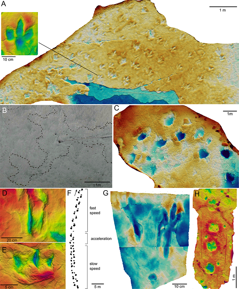
FIGURE 11. Non-anatomical features of tracks. A, Trackway from the Botucatu Formation showing pressure pads with multiple microfaults (Lower Cretaceous, Paraná Basin, Brazil). B, Trackway from the Botucatu Formation with pressure pads (sand crescents) and pronounced heteropody. C, Freshly made human track in moist sand, showing striations on the medial side and a large pressure pad with radial fractures on the lateral side. D, Trackway of a dog (Canis familiaris) descending a dry sand dune, photographed from the top of the dune. Note the avalanche structures that flow downslope, and the retreating scarp (Loope, 2006) that greatly enlarge the tracks upslope. E, Track of a modern raccoon (Procyon lotor) with a slip mark (left: orthophoto; right: elevation map). Note the striations within the impression.
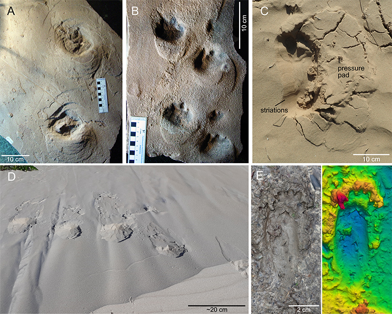
FIGURE 12. Sedimentary features associated with tracks. A, Wrinkle structures(Rugalichnus, see Stimson et al., 2017) resulting from the growth of a microbial mat, Hornburg Formation (middle Permian, Wolferode, Germany). Left: orthophoto; right: shaded relief. B, Wrinkle structures of a microbial mat associated with “Brachychirotherium” (Middle Triassic, Braies Dolomites, Italy). Photo: Marco Avanzini. C, Tool marks, possibly produced by floating vegetation, on the bed of the Letaba River, Kruger National Park, South Africa. Note the water cover, the invertebrate traces, and the large bird trackways (possibly saddle-billed stork, Ephippiorhynchus senegalensis).
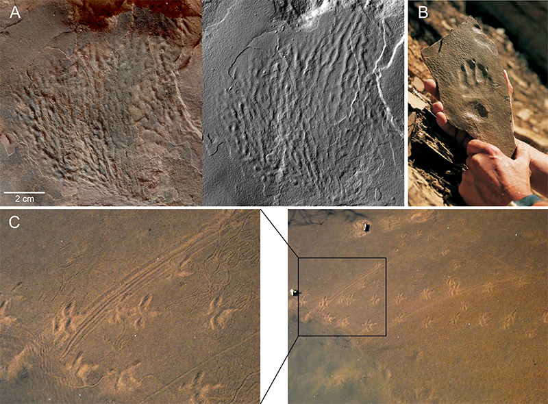
FIGURE 13. Descriptive terminology for feet and tracks. A, Toe configurations in modern birds. B, The axony, as determined by the position of the axis of an foot or track (here, right feet). C, The classification of foot static postures, from plantigrady (the entire foot is in ground contact) to unguligrady (only the unguals are in ground contact). The autopodial elements shown, from right to left, are the unguals (orange), the non-ungual phalanges (yellow, 2x), the metapodials (red), and the carpals/tarsals (green). See text for details.
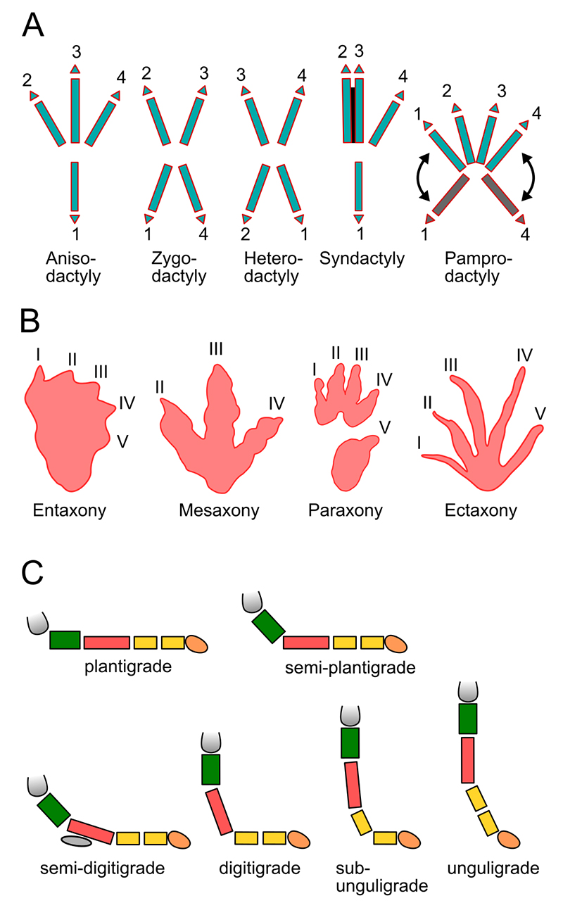
FIGURE 14. Features and measures of tracks and trackways. A, Measurement scheme with a tridactyl dinosaur track as example. B, Additional measures, with a pentadactyl track (Dromopus) as example. Redrawn after Leonardi et al. (1987). C, Track of a modern Coyote (Canis latrans), redrawn after Halfpenny (1986). D, Track of a modern camel, after Sarjeant and Reynolds (1999) and Lucas and Hunt (2007). E, Hoof of a modern horse in plantar view, after Vincelette et al. (2023). F, Terminology and measures for human tracks. G, Basic measures for a bipedal theropod trackway. Trackway T3, Münchehagen, Germany; see Lallensack et al. (2016). H, Additional trackway parameters shown on a quadrupedal sauropod trackway. GAD-0, GAD-25, GAD-50, and GAD-75 refer to the gleno-acetabular distance (GAD) assuming a particular limb phase (0%/100% to 75%). Trackway S1, Greenland; see Lallensack et al. (2017). I, Bounding trackway of a modern rabbit, showing the concept of group and intergroup. After Halfpenny (1986).
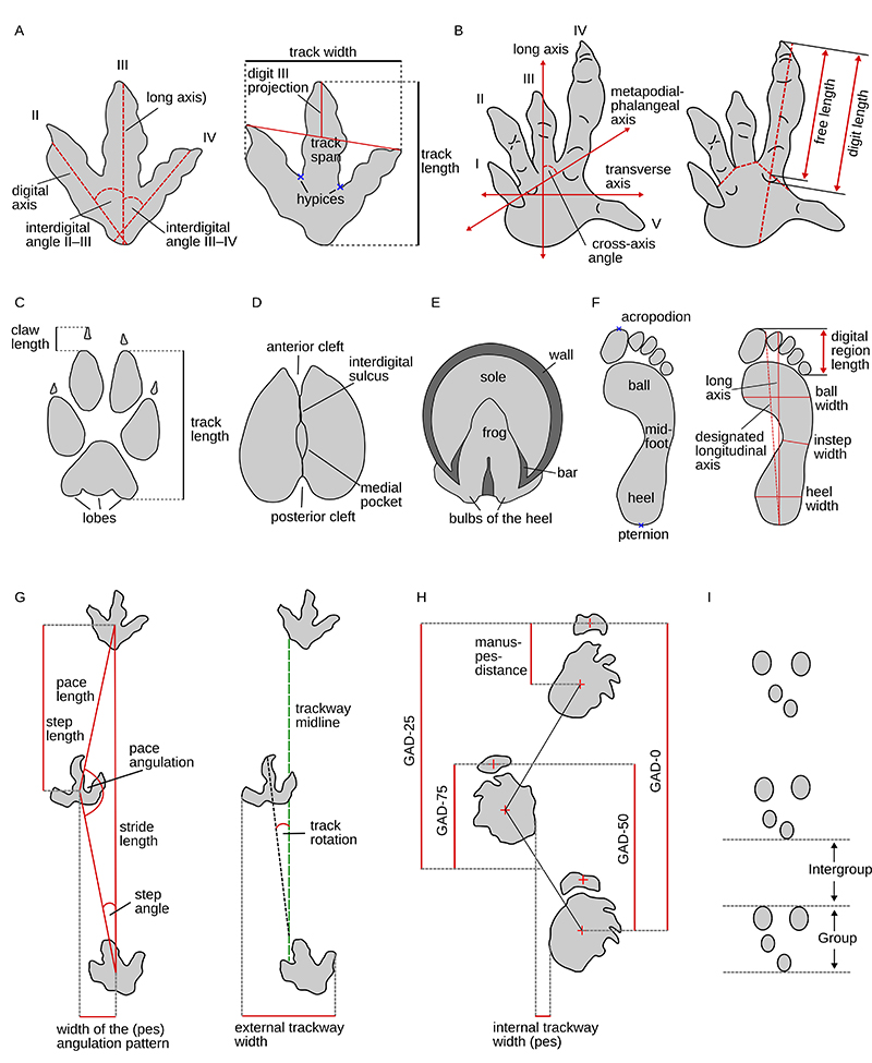
FIGURE 15. Classification of symmetrical quadrupedal gaits. A, Hildebrand diagram showing the classification of gaits based on limb phase and duty factor. The gait space occupied by modern mammals as well as by selected mammals is shown. After Hildebrand (1976, 1989), Cartmill et al. (2002), and Lallensack and Falkingham (2022). B, The influence of differences in limb phase on the trackway pattern, with trackmaker size and speed being constant. Squares represent the footfall positions of the pedes and circles those of the manus. Footfalls are shown in black if the foot is currently in ground contact, and previous and future footfalls are shown in grey. Note how the manus-pes distance increases with increasing limb phase (from a negative value at a limb phase of 0% (or 100%) to more than half a stride length at a limb phase of 75%). Redrawn from Lallensack and Falkingham (2022).
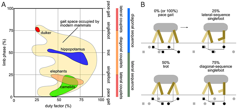
FIGURE 16. Integumentary impressions in tracks. A, Tracks of an African bush elephant (Loxodonta africana) showing ridges that result from furrows on the underside of the foot, which enhance traction. The shown impression is a manus-pes set, with the pes overprinting most of the manus. Kruger National Park, South Africa. B, Dimetropus track from the Lower Permian Boskovice Basin, Czech Republic, showing flexion creases; Calábková et al. (2023). Photograph: Gabriela Calábková. C, Skin impressions in a Synaptichnium track (Middle Triassic, Berndorf, Germany). Collection Hendrik Klein; photograph: Michael Buchwitz. D, Pes and manus track of a modern Nile crocodile (Crocodylus niloticus) with skin impressions (Kruger National Park, South Africa).
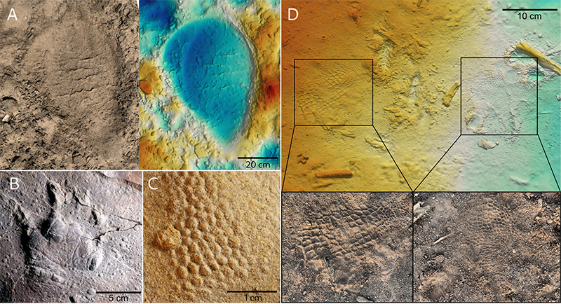
FIGURE 17. Trackway features and their interpretation. A, Ornithopod trackway, Valdeté tracksite, La Rioja, Spain (Lower Cretaceous; Enciso Group). This trackway shows discrepancies between the left and right pace lengths and has therefore been interpreted as an example of a “limping trackway”, implying a pathology (Moratalla, 1993; Lockley et al., 1994b). Note here that such left-right discrepancies can also be the result of footedness. B, Bipedal dinosaur trackway showing a groove that extends from track to track (indicated by arrows), which is interpreted as a tail drag mark (Pérez-Lorente, 2015), Peñaportillo tracksite, La Rioja, Spain (Lower Cretaceous; Enciso Group). C, tail drag mark of a modern Nile crocodile (Crocodylus niloticus; Kruger National Park, South Africa). Note the longitudinal grooves. D, Theropod (Eubrontes) trackway showing digit drag marks leading into and out of the tracks (Lower Jurassic, Connecticut Valley; Paläontologisches Museum München). E, Theropod trackway of three tracks from the Hitchcock collection, Beneski Museum of Natural History (6A/2; Lower Jurassic, Connecticut Valley, US). The first and third track shows an apparent didactyl morphology, with digit impression II being very indistinct or absent. Note also the very long stride lengths (relative stride: 2.7), which suggest this individual might have been running. F, Orthophoto of the takeoff trace of a larger bird (recent; Florianopolis, Brazil). The trackway first indicates a regular walk, then transitions to a skipping gait as the bird flaps its wings to take off; the two rightmost tracks are the last of the trackway.