FIGURE 1. Overview of the geological and palaeontological heritage of Dinosaur Provincial Park (DPP) within the context of a digital elevation model (DEM). A, location of drone flight area covering Bonebed 190 among significant fossil quarries and other geological features within DPP. Quarry and formational contact locations available from database assembled by first author, updated from Currie and Koppelhus (2005); bentonite locations available from Ramezani et al. (2022). Numbers indicate Oldman-Dinosaur Park Formation contacts which are compared with OF-DPF contact measured in this study (see Figure 7B). DEM assembled by aerial Lidar scanning in 2015, provided courtesy of Royal Tyrrell Museum of Palaeontology (TMP). Elevation contour lines redrawn from topographic map of DPP (Dinosaur Provincial Park World Heritage Site, 2013) georeferenced on QGIS. B, absolute elevation extracted from TMP DEM for all points measured along OF-DPF contact during a differential GPS survey occurring from 1999 to 2003 along an east-west axis. Coordinates in WGS84 / Universal Transverse Mercator zone 12N, EGM96 geoid. Dashed light blue rectangles indicate same series of points measured around TMP field station and DPP public loop road.
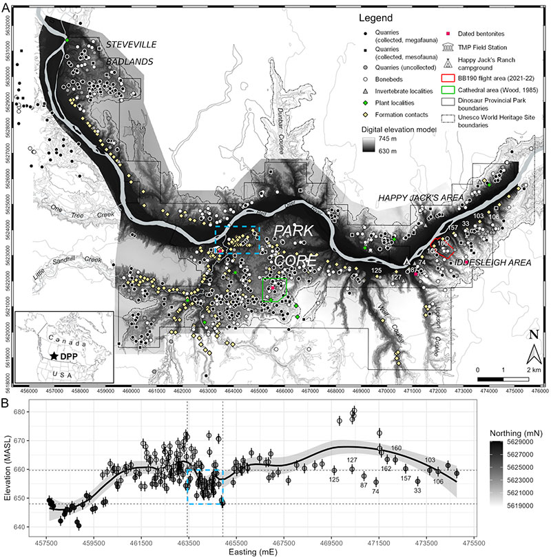
FIGURE 2. Overview of unmanned aerial vehicle (UAV) structure-from-motion (SfM) photogrammetry process leading to creation of digital outcrop model (DOM), digital elevation model (DEM) and orthomosaic of Bonebed 190 Amphitheatre area; survey area 0.446 km2. A, UAV camera locations and image overlap obtained from Agisoft Metashape processing report: colour palette indicates number of overlapping images per grid cell. B, UAV camera location error estimates along flight paths obtained from Agisoft Metashape processing report: Z error represented by ellipse colour; X, Y errors represented by ellipse shape; estimated camera locations marked with black dot. C, perspective render of dense 3-D point cloud generated from UAV image alignment followed by geolocation optimization with ground control points (GCPs, marked with flags). Image dataset combined from 2021 and 2022 flights; 2022 images (including some taken at 45˚ pitch angle) cover well-exposed Oldman-Dinosaur Park Formation contact. D, orthographic render of dense 3-D point cloud coloured by point confidence; blue represents highest point confidence, as seen on the outcrop photographed at oblique angles (see Figure 2C). E, DEM with GCP locations, significant fossil quarries and measured Oldman-Dinosaur Park Formation contacts. Coordinates in WGS84 / Universal Transverse Mercator zone 12N, EGM96 geoid. Quarry and formational contact locations available from database assembled by first author, updated from Currie and Koppelhus (2005). Black crosses mark start and end points of main stratigraphic section measured during 2022 field season. F, inset of image captured during 2021 flight at low elevation over BB190 host horizon; note GCP made of two white Jacob's staffs (GCP 21_3 in Figure 2E).
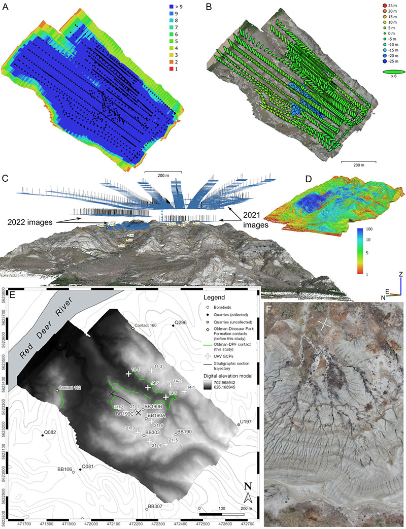
FIGURE 3. Orthomosaic of Bonebed 190 Amphitheatre area highlighting contacts between identified architectural sedimentary units. Coordinates in WGS84 / Universal Transverse Mercator zone 12N. ‘BB190’ point marks original quarry stake marked in 2002; ‘BB190A-C’ and ‘BB303’ points mark fossil-rich localities discovered during this study. Note semi-circular shape formed by ridge marked by dark red contact between Rhythm 3 mudstone and Rhythm 4, hence the proposed ‘Amphitheatre’ toponym. Quarry and formational contact locations available from database assembled by first author, updated from Currie and Koppelhus (2005).
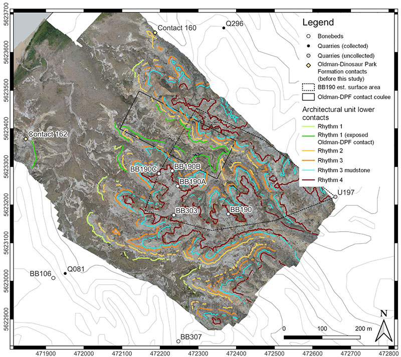
FIGURE 4. Visualization of architectural units of BB190 Amphitheatre area using stratigraphic section and digital outcrop model (DOM). A, stratigraphic section measured along secondary coulee leading to BB190. B, orthographic render of DOM displaying outcrop exposures measured for stratigraphic section. C, cross-sectional photograph of clay-pebble conglomerate forming erosional contact between MUD3 and TX4, hosting ceratopsid pubis collected from BB190B quarry. Colour code for lower contacts of architectural sedimentary units identified across entire mapped area same as in Figure 3; burgundy arrowheads mark sandstone ribbon cutting into MUD2. Black strokes indicate extent of measured outcrops, dashed arrows indicate interruptions in continuous sequence measurements. Lower half of section corrected during examination of DOM after fieldwork. Abbreviations: M and MUD, mudstone; Si, siltstone; FS, fine-grained sandstone; CS, coarse-grained sandstone; P, pebbles; TX, trough cross-bedded sandstone; DPF, Dinosaur Park Formation; OF, Oldman Formation.
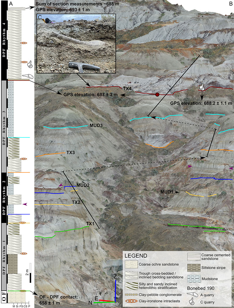
FIGURE 5. Perspective renders of digital outcrop model (DOM) highlighting channel cut-and-fill rhythm succession above a continuously exposed Oldman-Dinosaur Park Formation (OF-DPF) contact extending along both flanks of the coulee located along the northern margin of the BB190 Amphitheatre area. OF-DPF contact marks base of Rhythm 1 sandstone. A, exposure on northern slope of the coulee. B, close-up of A from a different viewing angle; note occasional thick blocks of silty ironstone at the OF-DPF contact, dark red clay-ironstone table at base of Rhythm 2 sandstone and laterally discontinuous sandstone ribbon cutting within Rhythm 2 mudstone. C, exposure on southern flank of the coulee; note southeastward slump in OF-DPF contact and vertical amalgamation of sandstone units pinching out mudstone units to the southeast. Ticks mark bases of each identified lithological unit, points marked with flags indicate digital sections traced to measure local rhythm depths in Agisoft, white asterisk indicates same location in A and B.
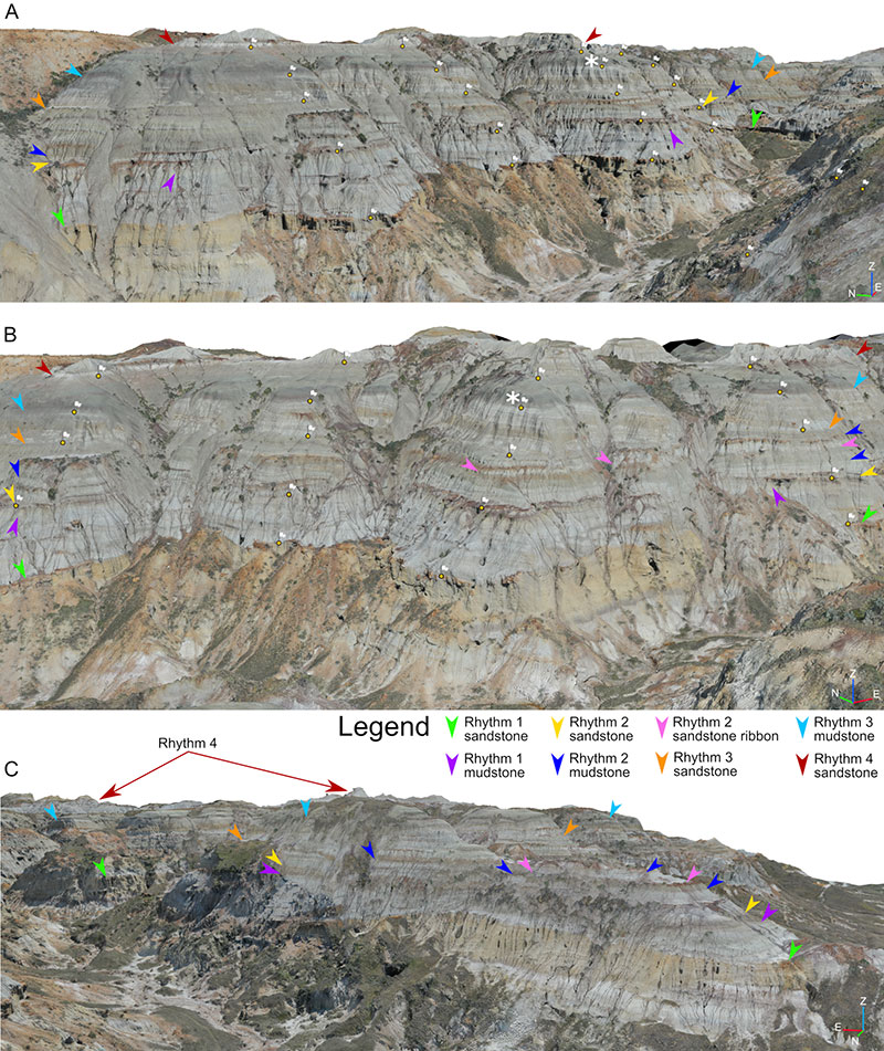
FIGURE 6. Additional renders of digital outcrop model (DOM) highlighting channel cut-and-fill succession in the BB190 Amphitheatre area. A, perspective render of exposure of rill forming southern margin of secondary coulee along which the main stratigraphic section was measured (see Figure 4). Oldman-Dinosaur Park Formation contact marks base of Rhythm 1 sandstone; note change in direction of lateral accretion of ochre siltstone ribbons above and below contact with Rhythm 2 sandstone, as well as laterally discontinuous sandstone ribbon cutting within Rhythm 2 mudstone. B, perspective render of exposure on southern margin of BB190 Amphitheatre area highlighting subtle contact between Rhythms 1 and 2; note Rhythm 2 sandstone downcutting Rhythm 1 mudstone at contact marked by dark red clay-ironstone table. C, orthographic render of uppermost exposures of the Dinosaur Park Formation located upstream from Figure 6B, where the plateau hosting the bonebed narrows into a ridge stretching to the southeast beyond the reaches of the DOM; note possible initiation of a new rhythm at the top of Rhythm 4 with different directions of lateral accretion above and below the proposed contact. Ticks mark bases of each identified lithological unit; black asterisk marks same location in B and C.
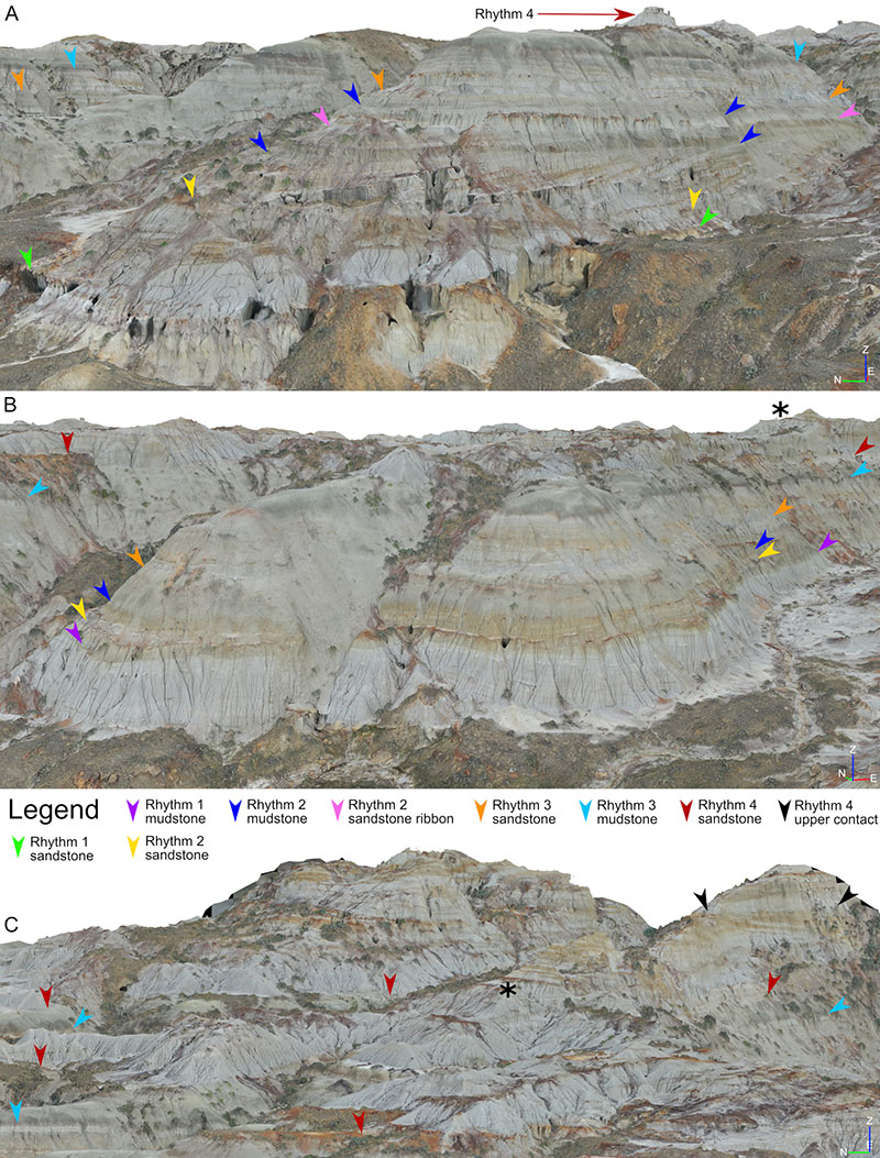
FIGURE 7. Measurement of architectural unit contacts within and beyond BB190 Amphitheatre area. A, measurement of Oldman-Dinosaur Park Formation (OF-DPF) contact elevation solely within a wide coulee forming northern margin of Amphitheatre area; elevation extracted from digital elevation model (DEM) generated during this study and 95% confidence interval of trend curves. B, comparison of OF-DPF contact elevations between aforementioned coulee and all contacts measured along Dinosaur Provincial Park (DPP) eastern right bank during DGPS survey in the early 2000s; elevation for both groups extracted from DEM generated during aerial Lidar survey of DPP. Mean contact elevations with standard errors are as follows: 658.64 ± 0.18 m (BB190 area), 659.46 ± 0.84 m (DPP East right bank). Vertical dashed lines indicate extent of region studied in Figure 7A; horizontal dotted line indicates ~0.05˚ average structural dip of DPP exposures to the northwest. C, comparison of architectural unit lower contacts across BB190 Amphitheatre area. Elevation extracted from DEM generated during this study, with 95% confidence interval of trend curves; vertical dashed lines indicate extent of region studied in Figure 7A; error bars omitted to improve point visibility; standard error provided with mean elevation for each contact.
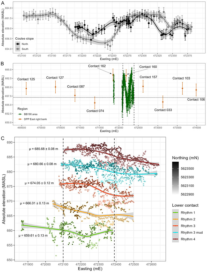
FIGURE 8. Location of significant fossil specimens collected within Bonebed 190 horizon. A, overview of BB190 host horizon within Rhythm 4; ‘BB190’ point marks original quarry stake marked in 2002; ‘BB190A-C’ and ‘BB303’ points mark fossil-rich localities discovered during this study. Coordinates in WGS84 / Universal Transverse Mercator zone 12N, EGM96 geoid. B, location of significant fossil specimens along BB190 horizon at base of Rhythm 4, projected on perspective render of digital outcrop model. C, complete left hadrosaur dentary collected in 2023 near eastern edge of Amphitheatre, ~8m above main BB190 horizon; photo courtesy of Andre Mueller. D, fused tyrannosaur nasals collected in 2023 about halfway between BB190 original quarry height and BB303 quarry height. E, bowfin (family Amiidae) dentary collected in 2022 at BB190A quarry, 10 cm above main bonebed horizon; photo courtesy of Hans Larsson. F, centrosaurine ceratopsid nasal horn core with premaxilla collected in 2018 at BB190C quarry, at northwestern edge of Amphitheatre. G, ceratopsid (cf. Styracosaurus) parietal fragment found ex situ in 2019 near BB190 microsite.
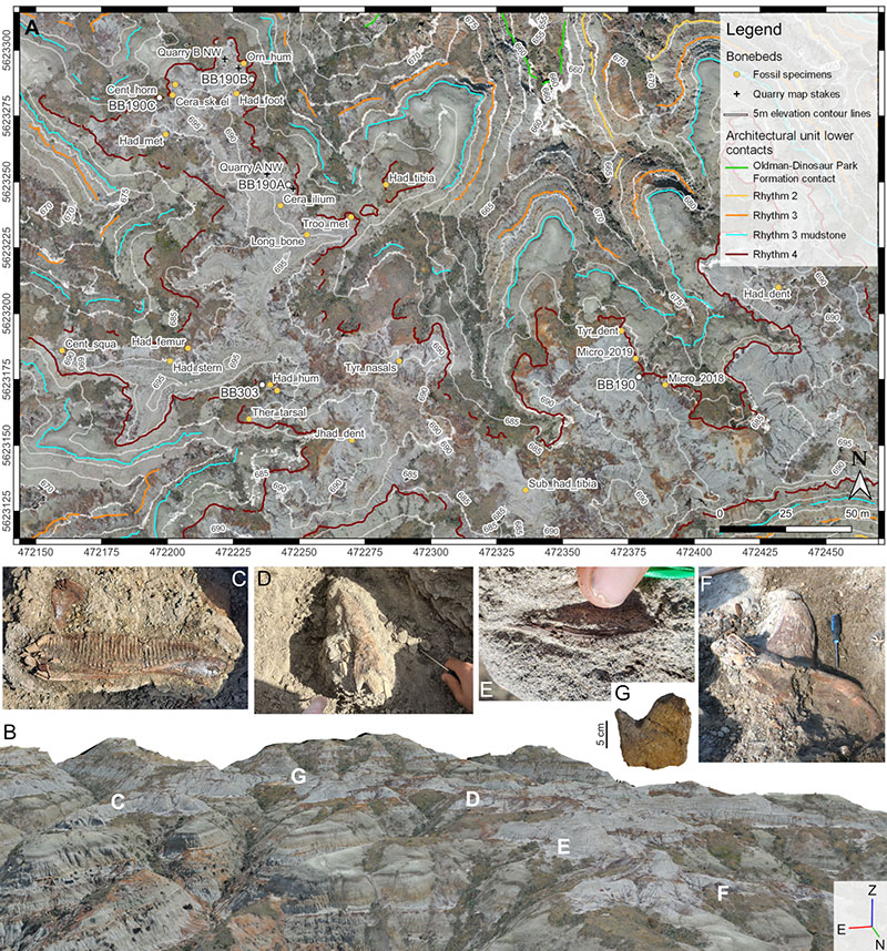
FIGURE 9. Examination of BB190A and BB303 localities. A, BB190A quarry map overlain on orthomosaic. BB190A point represents location of stake for original 2019 quarry map; NW and SE stakes mark corrected 2022 quarry map. B, nodosaurid parascapular spine uncovered from BB190A quarry in 2018. C, nodosaurid left ischium uncovered from BB190A quarry in 2019. Coordinates in WGS84 / Universal Transverse Mercator zone 12N, EGM96 geoid. Quarry and formational contact locations available from database assembled by first author, updated from Currie and Koppelhus (2005). D, perspective render of narrow coulee hosting BB303 locality. E, hadrosaur maxilla found in coarsening upward sandstone at base of clay-ironstone intraclast lens. F, short sedimentary log of BB303; burgundy stroke marks same contact (between MUD3 and Rhythm 4) as in Figure 9D. Abbreviations: M, mudstone; Si, siltstone; FS, fine-grained sandstone; CS, coarse-grained sandstone; P, pebbles.
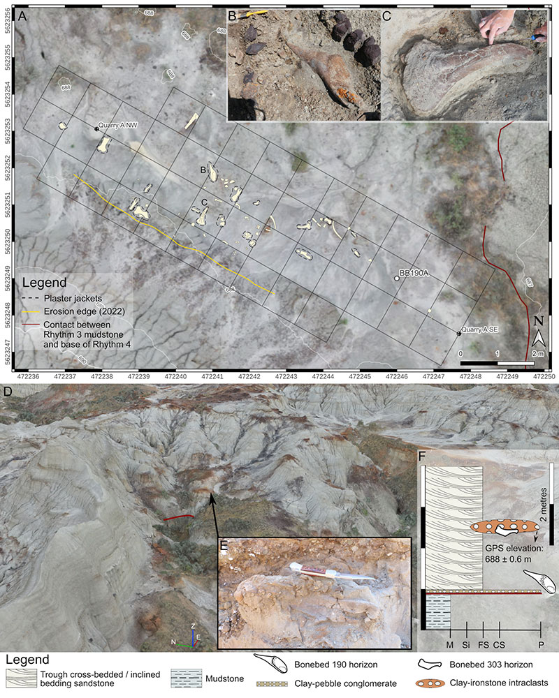
FIGURE 10. Heights of main bonebed quarries and individual fossil specimens above significant architectural unit contacts identified across the BB190 Amphitheatre area. A, location of selected Oldman-Dinosaur Park Formation (OF-DPF) contacts for estimating average specimen/bonebed relative height overlain on digital elevation model (DEM) of study area. Dashed lines connect BB190A (used as example) to all selected contacts; points highlighted in red and yellow represent contacts sampled along point series generated from DEM. Coordinates in WGS84 / Universal Transverse Mercator zone 12N, EGM96 geoid. B, heights above OF-DPF contact estimated from DEM for the five main BB190 quarries identified in this study, based on (1) Contacts 160 and 162 (available from Currie and Koppelhus, 2005); (2) 10 points selected along northern slope of coulee with longest continually preserved OF-DPF contact (red in Figure 10A); (3) 11 contacts selected across entire study area (including Contacts 160 and 162 and additional black points in Figure 10A). Larger points correspond to group means, and error bars represent standard deviations. Point colours in A and B refer to the same groups. C, heights above Rhythm 4 contact for significant bonebed quarries and collected fossil specimens, compared between heights measured with GPS in the field and heights extracted from DEM at nearest point(s) to each specimen along contact polyline traced in QGIS. Dotted line 1.5 m above that marks hypothetical second bonebed layer. Localities ranked by longitude, with the westernmost on the left; notable specimens recovered from BB190A (nodosaurid parascapular spine) and BB190C (centrosaurine nasal horn core) overlie their respective quarry heights; asterisks mark specimens located significantly higher than all others. Note that the same coordinates obtained along the stratigraphic section were used to measure several heights obtained from GPS readings due to lack of raw data, which explains negative values. Specimen and location abbreviations: Cent_squa, centrosaurine squamosal; Cera, ceratopsid; Had, hadrosaurid (adult); Orn, ornithomimid; Jhad, juvenile hadrosaurid; Shad, subadult hadrosaurid; Ther, indeterminate theropod; Troo, troodontid; Tyr, tyrannosaurid; brain, braincase; dent, dentary; hum, humerus; isch, ischium; max, maxilla; met, metatarsal; sk_el, skull element; stern, sternal plate; Micro, microsite points measured in 2018 and 2019.
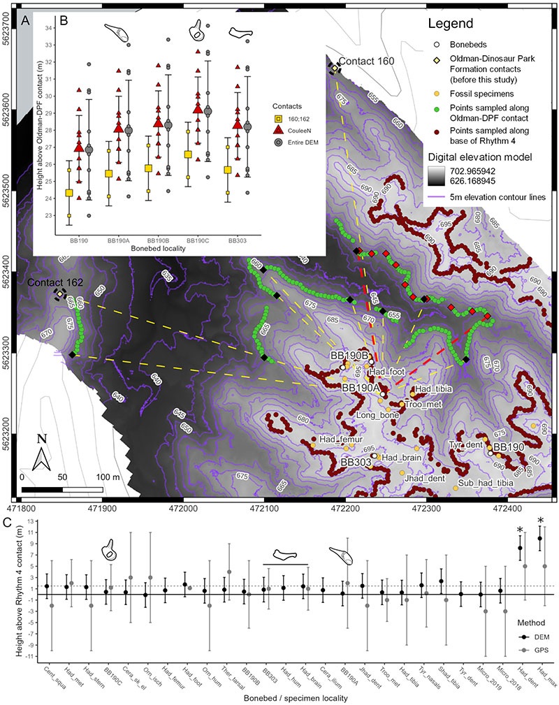
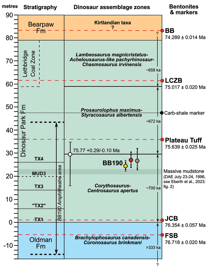
FIGURE 11. Bonebed 190 placed in the litho- and biostratigraphic context of Dinosaur Provincial Park, modified from Eberth et al. (2023). BB190 (original quarry) height above Oldman-Dinosaur Park Formation contact based on three groups of points sampled along contact as in Figure 10B, with mean, minimum and maximum height (as well as error bars representing standard deviations) on display for each group; note that those heights were not corrected for channel downcutting (see Discussion). Thick dashed black lines indicate approximate upper and lower relative height boundaries of mapped area; thinner dashed black lines indicate mean height of lower contact for each architectural unit identified in BB190 Amphitheatre area, MUD3 highlighted among other units’ mudstones due to greater potential as a marker bed, TX2 bracketed due to less certain validity as distinct architectural unit (see main text). Radioisotopic age uncertainty of biozone boundary projected on relative height axis based on latest published rock accumulation rates between each bentonite (Eberth et al., 2023). Abbreviations: BB, Bearpaw bentonite; FSB, Field Station bentonite; JCB, Jackson Coulee bentonite; LCZB, Lethbridge Coal Zone bentonite; MUD, massive mudstone; TX, trough cross-bedded sandstone.