

Volume 28.2
May–August 2025
Full table of contents
ISSN: 1094-8074, web version;
1935-3952, print version
Recent Research Articles
See all articles in 28.2 May-August 2025
See all articles in 28.1 January-April 2025
See all articles in 27.3 September-December 2024
See all articles in 27.2 May-August 2024
Interested in submitting a paper to Palaeontologia Electronica?
Click here to register and submit.
 |
||||
 |
||||
Article Search
Table 1. Measurements of footprints DFMMh/FV 644-648 as indicated in Figure 3.
| DFMMh/FV Specimen no. | 644 | 645 | 646 | 647 | 648 | |
| Length | [cm] | 46 | 44 | 36.2 | 36.4 | 47.4 |
| Width | [cm] | 52 | 36.7 | 32.9 | 34 | 48.8 |
| Span | [cm] | 47.2 | 30.8 | 29.7 | 30 | 42 |
| Depth | [cm] | 9.3 | 10.3 | 9.4 | 6.5 | 11.4 |
| Total digit divarication | [°] | 67 | 43 | 73 | 63 | 72 |
| Digit divarication II/III | [°] | 33 | 33 | 26 | 46 | 32 |
| Digit divarication III/IV | [°] | 34 | 10 | 47 | 17 | 40 |
APPENDIX 1.
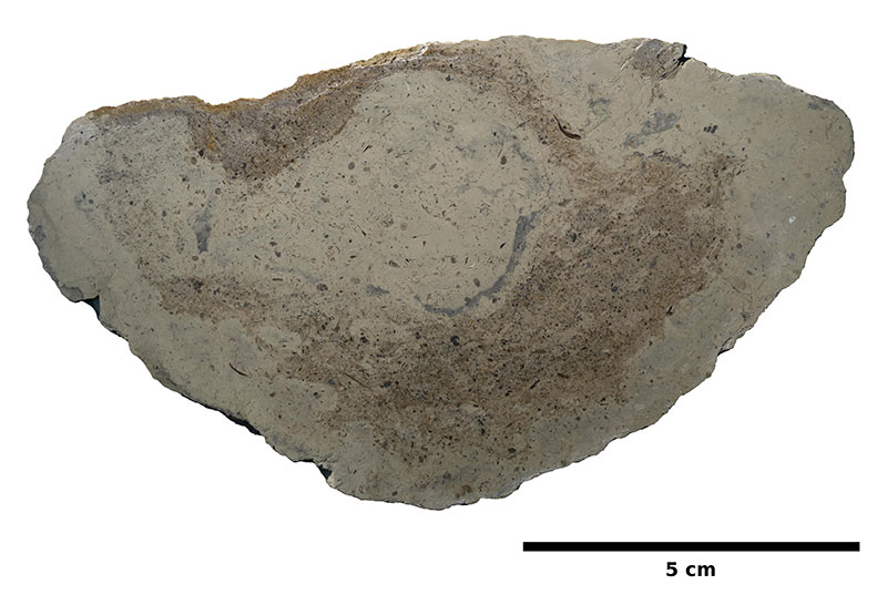
Photograph of a polished cross section of the cast of a digit impression, revealing a gastropod rich biomicrite.
APPENDIX 2.
Three-dimensional model of the original Langenberg tracksite, based on archival photographs (taken by Nils Knötschke and Holger Lüdtke, 2003). Data is provided as a Adobe 3D-pdf and a PLY file with accompanying texture file. (Available in zipped file.)
APPENDIX 3.
Three-dimensional photogrammetric model of DFMMh/FV 644. Data is provided as a Adobe 3D-pdf and a PLY file with accompanying texture file. (Available in zipped file.)
APPENDIX 4.
Three-dimensional photogrammetric model of DFMMh/FV 645. Data is provided as a Adobe 3D-pdf and a PLY file with accompanying texture file. (Available in zipped file.)
APPENDIX 5.
Three-dimensional photogrammetric model of DFMMh/FV 646. Data is provided as a Adobe 3D-pdf and a PLY file with accompanying texture file. (Available in zipped file.)
APPENDIX 6.
Three-dimensional photogrammetric model of DFMMh/FV 647. Data is provided as a Adobe 3D-pdf and a PLY file with accompanying texture file. (Available in zipped file.)
APPENDIX 7.
Three-dimensional photogrammetric model of DFMMh/FV 648. Data is provided as a Adobe 3D-pdf and a PLY file with accompanying texture file. (Available in zipped file.)
APPENDIX 8.
Three-dimensional photogrammetric model of DFMMh/FV 647 in situ, based on three archival photographs (taken by Nils Knötschke and Holger Lüdtke, 2003). Data is provided as a Adobe 3D-pdf and a PLY file with accompanying texture file. (Available in zipped file.)
FIGURE 1. Location and stratigraphy of the Langenberg locality. 1: Paleogeographic map of the Late Jurassic (150 Mya) of Central Europe, showing the five main regions which contain dinosaur tracks: (1) Swiss Jura Mountains; (2) French Jura Mountains; (3) Lot (France); (4) Holy Cross Mountains (Poland); (5) Wiehen Mountains (Germany) as well as the Langenberg tracksite (6), which is described herein. Map reconstruction from Ron Blakey, Colorado Plateau Geosystems, Arizona, USA (cpgeosystems.com/paleomaps.html). 2: Geographical position of the Langenberg Quarry near Goslar. 3: Measured section of a part of the “Mittlerer Kimmeridge”, redrawn from Fischer (1991).
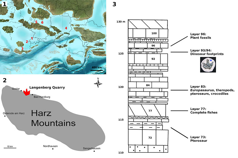
FIGURE 2. The Langenberg tracksite during excavation. Left: Archival photograph by NK (2003). The white box shows the location of the tracksite. Right: Digitally cropped version of the photograph, showing the tracksite (the whitish spot on the right slab represents plaster). See also Figure 9 for depth-color images of the photogrammetric model and Figure 10 for an orthofoto and an interpretative drawing.
FIGURE 3. Schematic outline drawings (based on footprint DFMMh/FV 644 from the Langenberg tracksite) showing basic footprint and trackway parameters, measured lines and angles are highlighted in blue. Gray areas indicate claw marks. 1: Digit divarication, measured in degrees between the digital axes (da) of digit II and III and III and IV. The footprint span (Sp) was measured between the distal ends of the axes of digit impressions II and IV. 2: Footprint length and width. Footprint width was measured at a right angle to the digital axis of digit III. 3: Basic trackway parameters following Marty (2008) (RP: right pes; LP: left pes; S: stride length; WAP: Width of the pes angulation pattern; γ: pace angulation).
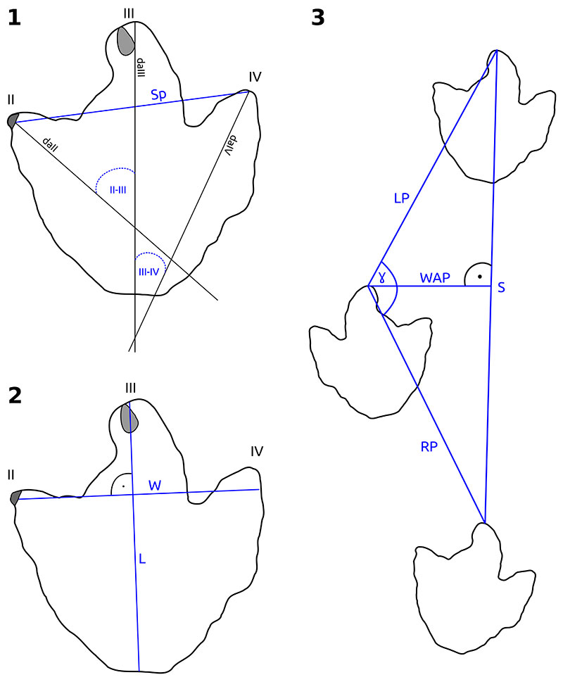
FIGURE 4. Historical photogrammetry based on photographs of limited quality. Footprints 14 and DFMMh/FV 647 are only visible on very few archival photographs and thus do not appear in the photogrammetric model of the whole tracksite. 1-3: The only three detail photographs showing DFMMh/FV 647 in situ. Note that photographs 2 and 3 are nearly identical. Photograph 1 was taken by NK, while photographs 2 and 3 were taken by Holger Lüdtke at the time of excavation in 2003. 4: Photogrammetric model (depth-color image) of DFMMh/FV 647, based only on the three detail photographs (1-3), the minimum number of photographs required by the software to generate a model. This model reveals additional details (most importantly the impression of digit II), which were lost during excavation of the footprint. 5: Detail of the best photograph showing footprint 14 (digitally cropped version of an original archival photograph by NK from 2003). Note the poor resolution and the low angle of the photograph. The approximate position and width of this footprint was determined by placing marker points on the photographs and using the camera alignment performed by Agisoft Photoscan to project these marker points on the 3D model.
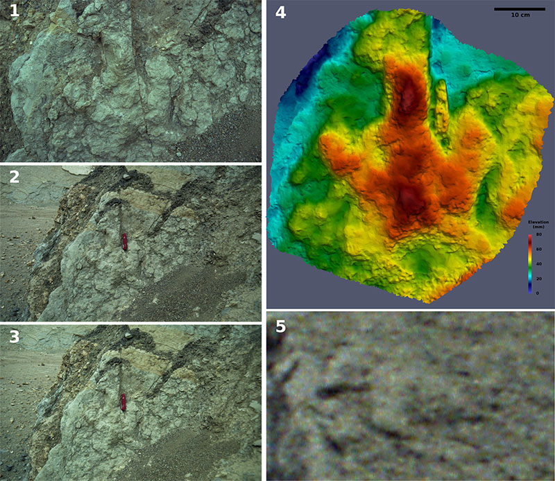
FIGURE 5. Photogrammetric pitfalls: Depth-color image of an incorrect photogrammetric model resulting from an erroneous alignment of the photographs. Arrows indicate artifacts, including crack-like structures running from the left to the right as well as longitudinal structures running down the slab which resemble ripple marks.
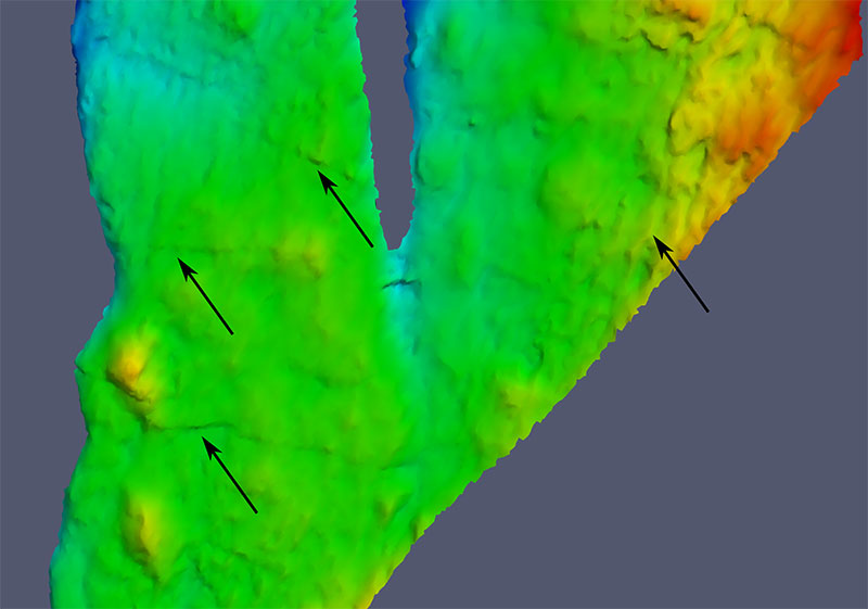
FIGURE 6. Depth-color images (left) and orthophotos (right) of 1: DFMMh/FV 647, 2: DFMMh/FV 646, 3: DFMMh/FV 645 and 4: DFMMh/FV 644. Images to scale.
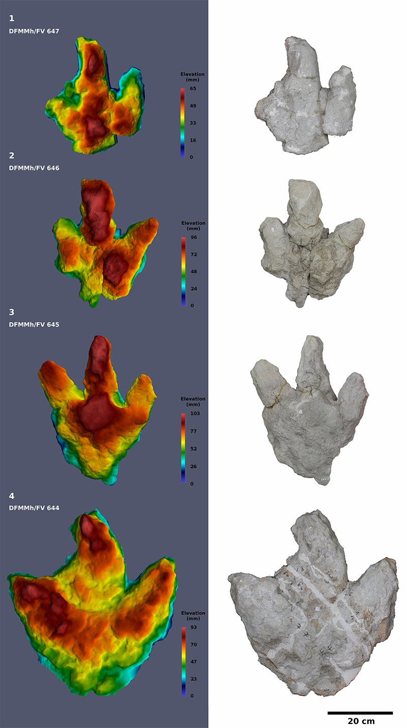
FIGURE 7. Depth-color image (left) and orthophoto (right) of DFMMh/FV 648. Not to scale with Figure 6.
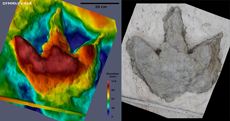
FIGURE 8. Recent photograph of DFMMh/FV 648, the best preserved footprint, photographed at a low angle. The arrow shows the strongly inclined digit impression IV.
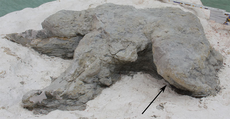
FIGURE 9. The most detailed regions of the historical photogrammetric model, shown as depth-color images. 1: Part of the left slab. Trackway 1 (footprints 6-9) and parts of trackway 2 (footprints 12 and 13) can be seen. The lineaments within trackway 1 and on the right of footprint 644 represent meter sticks incorporated into the photogrammetric model. 2: Part of the right slab. The excavated footprints DFMMh/FV 644 and 646, footprint 23, trackway 3 (footprints 20, 21, and 22) and possible additional footprints (24, 25, 26) can be seen. Compare with Figure 10. Scale bar: 1 m, 1 and 2 are to scale.
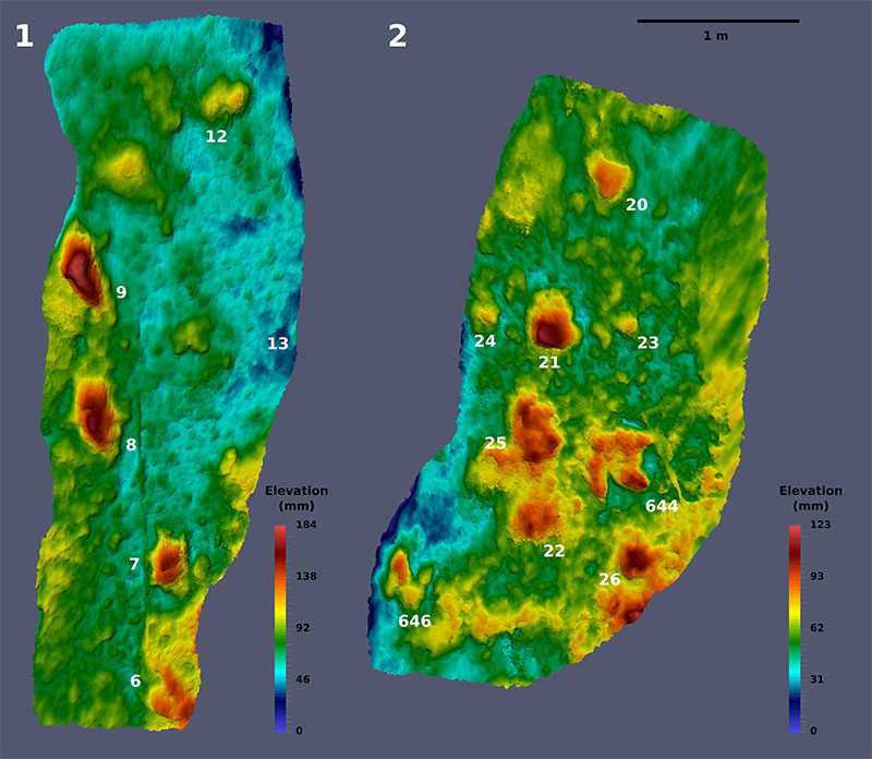
FIGURE 10. Complete historical photogrammetric model of the Langenberg tracksite. Left: Orthophoto; right: sitemap. Confirmed footprints are drawn in red, and elevations that might represent additional tracks are drawn in gray. Note that DFMMh/FV 645 and 648 do not appear on this chart, because the position of these footprints on the tracksite was not documented by photographs. Sitemap and orthophoto to scale.
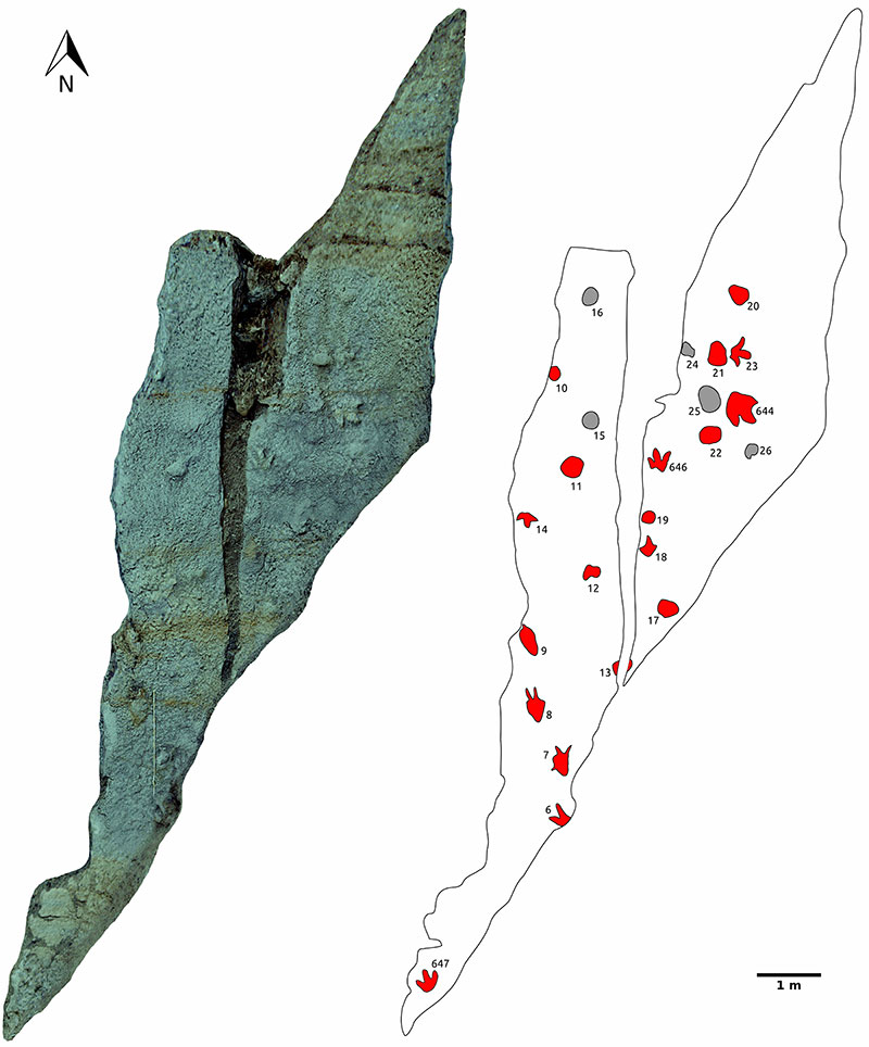
FIGURE 11. The three recognized trackways. The blue lines show the pace, the green lines the stride length. Arrows indicate direction of trackways. Measurements based on the historical photogrammetric model (pace length, stride length, and pace angulation) are included. Scale bars equal 1 m, respectively. Trackways are not to scale.
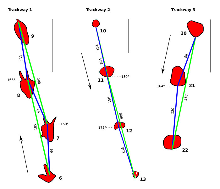
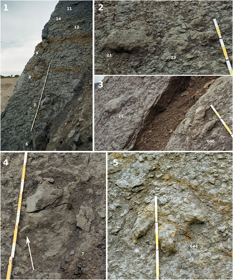
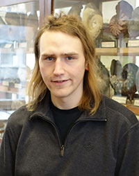
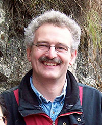
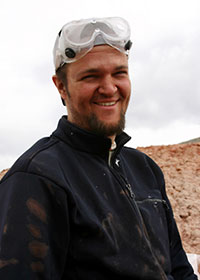
FIGURE 12. Details of the original tracksite. 1: Detail of the left slab, showing trackway 1 (footprints 6, 7, 8, and 9), parts of trackway 2 (footprints 11 and 12), and the isolated footprint 14. Archival photograph by Holger Lüdtke from 2003. 2: Detail of the right slab, showing a deep track (footprint 21) and a better defined track (footprint 22) in close proximity. Digitally cropped version of an archival photograph (NK, 2003). 3: Detail of the tracksite. Footprint 11 shows the morphology typical for the deep tracks of the site. Footprint DFMMh/FV 646 is a well-defined track. Digitally cropped version of archival photograph (Nils Knötschke, 2003). 4: Footprint 7, featuring a hallux impression, as shown by the arrow. Digitally cropped version of archival photograph by NK, 2003. 5: DFMMh/FV 644, as it was in situ prior excavation. Digitally cropped version of archival photograph by NK, 2003.
 Jens N. Lallensack
Steinmann-Institut für Geologie, Mineralogie und Paläontologie
Universität Bonn
Nussallee 8, 53115 Bonn, Germany
jens.lallensack@uni-bonn.de
Jens Lallensack received his Bachelor's degree in Geosciences at the University of Göttingen in 2012 and his Master's degree at the University of Bonn in 2014. He currently is a PhD student at the University of Bonn. Jens' research interests include coprolites, the osteology and taphonomy of basal sauropodomorph dinosaurs, and fossil footprints from dinosaurs and other tetrapods. For his research, he likes to apply novel techniques such as photogrammetry and geometric morphometrics.

 P. Martin Sander
Steinmann-Institut für Geologie, Mineralogie und Paläontologie
Universität Bonn
Nussallee 8, 53115 Bonn
Germany
m.sander@uni-bonn.de
P. Martin Sander is Professor at the Steinmann Institute of the University of Bonn and has been curator of its Goldfuß Museum for over 10 years. After his undergraduate work at the University of Freiburg in Germany, Dr. Sander obtained a Master's degree at the University of Texas at Austin in 1984 and a Ph.D. from the University of Zurich, Switzerland, in 1989. Since then, he has divided his research interests between the more traditional work in paleontology such as excavating and studying Triassic marine reptiles around the globe, and a more biological approach to extinct vertebrates, using the microstructure of fossil bone as a clue to life history and evolution. A spectacular application was the proof that dinosaurs were subject to island dwarfing. In 2004, Dr. Sander was able to obtain major funding from the German Research Foundation (DFG) for the study of this topic and since then has headed DFG Research Unit 533 "Biology of the Sauropod Dinosaurs: The Evolution of Gigantism". Since 1987, Dr. Sander has authored numerous scientifc papers and books on his research and since 1995 has trained many graduate students at the University of Bonn.
 Nils Knötschke
Dinosaurier-Freilichtmuseum Münchehagen
Alte Zollstrasse 5
31547 Rehburg-Loccum
Germany
n.knoetschke@dinopark.de
Nils Knötschke is the chief-preparator and scientific advisor of the Dinosaur Open Air Museum Münchehagen in Germany. This dinosaur park is arranged around a Natural Monument that protects more than 250 Cretaceous dinosaur tracks. Since 1999, Nils is leading excavations and the preparation of several dinosaur track sites and Jurassic vertebrates from the Langenberg Quarry with a special focus on the dwarfed sauropod dinosaur Europasaurus holgeri. His research interests are centered around the Europasaurus bones. Nils is also working on new preparation techniques and excavation methods.
 Oliver Wings
Landesmuseum Hannover
Willy-Brandt-Allee 5
30169 Hannover
and Germany & Museum für Naturkunde Berlin
Invalidenstraße 43
10115 Berlin
Germany
dr.wings@gmail.com
Oliver Wings started his research career in Solnhofen, Germany: for his Diplom thesis at the University of Erlangen-Nuremberg, he studied the first and only hardground known from the plattenkalks. After that he joined the vertebrate paleontology research group at the University of Bonn, studying gastroliths (stomach stones) in dinosaurs and extant birds for his dissertation. In the following years, he worked at several German institutions, such as the University of Tübingen, where he carried out research in Xinjiang, NW China, or the Museum of Natural History in Berlin, where he worked as acting curator for the fossil archosaur collections. He currently leads the Europasaurus Research Project at the State Museum Hannover on dwarfed sauropod dinosaurs and contemporaneous tetrapods from the Langenberg Quarry near Goslar. His other research interests include Jurassic vertebrates from China and Germany, paleobiology of archosaurs, vertebrate taphonomy, dinosaur trackways, and bone diagenesis.
Dinosaur tracks from the Langenberg Quarry (Late Jurassic, Germany) reconstructed with historical photogrammetry: Evidence for large theropods soon after insular dwarfism
Plain Language Abstract
Fossil footprints often provide the only evidence that a certain group of animals lived at a certain place at a specific time. Footprints of large predatory dinosaurs occur at the Langenberg quarry in Germany in a sediment layer only some 5 m (probably representing some 35,000 years) above the bones of the small plant-eating sauropod dinosaur Europasaurus. At 6 to 8 m in length, Europasaurus was much smaller than other sauropods, probably because it lived on a small island with limited food resources. Large predators as those recorded by the footprints were unable to thrive on such an island. This indicates that the island became connected to other landmasses at some point after the Europasaurus bones were deposited, allowing the immigration of the predators onto the island which probably have eliminated the resident Europasaurus population. Unfortunately, the footprint site was destroyed by quarrying soon after its discovery, with only 5 out of 20 footprints being excavated and preserved, and only analog photographs of the destroyed footprints remaining. We were able to derive a wealth of data on the destroyed footprints and their arrangement by calculating a three-dimensional model from the photographs, using a technique known as historical photogrammetry. This model provided information on the early development of the site, indicating that the trackways were not left simultaneously but during a longer time span, possibly of days or even months.
Resumen en Español
Huellas de dinosaurios de la Cantera de Langenberg (Jurásico tardío, Alemania) reconstruidas con fotogrametría histórica: evidencia de grandes terópodos poco después de enanismo insular
Se describen huellas de dinosaurios de la cantera de Langenberg cerca de la localidad de Goslar (Baja Sajonia) las cuales representan las primeras huellas del Jurásico tardío de Alemania descubiertas fuera del macizo del Wiehengebirge. Las huellas se conservan en carbonatos marinos marginales del Kimmeridgiense. Varían en longitud, de 36 a 47 cm, y fueron producidas por dinosaurios terópodos. El rastro original que contenía 20 huellas fue destruido por la explotación minera poco después de su descubrimiento en 2003. Sólo fueron excavadas las cinco huellas mejor definidas. Se ha generado un modelo tridimensional (3-D) del rastro original mediante la aplicación de la fotogrametría histórica a partir de la digitalización de las fotografías analógicas que fueron tomadas durante la excavación. El modelo resultante es lo suficientemente preciso como para permitir una descripción detallada del rastro original de huellas. Los diferentes tipos de conservación son el resultado de la variación en las propiedades del sustrato e incluyen tanto huellas bien definidas como huellas de impresión profunda con talón alargado e impresiones de dedos con definición variable. El rastro de huellas se descubrió situado estratigráficamente cercano a la acumulación de huesos del dinosaurio saurópodo enano Europasaurus holgeri y probablemente registra una caída del nivel del mar junto con un intercambio de fauna, lo que probablemente habría eliminado a los residentes enanos de la fauna insular. Las dos huellas más grandes y mejor conservadas difieren en su gran anchura de la mayoría de huellas de terópodos del Jurásico tardío. Las huellas fueron producidas, al menos, por dos especies diferentes. Se comentan aquí varias hipótesis que fueron recientemente presentadas en un artículo, por Diedrich (2011b), sobre huellas de dinosaurios del Jurásico tardío del macizo del Wiehengebirge.
Palabras clave: Jurásico tardío, huellas de dinosaurios, Theropoda, enanismo insular, fotogrametría
Traducción: Enrique Peñalver
Résumé en Français
Les empreintes de dinosaure de la Carrière de Langenberg (Jurassique Supérieur, Allemagne) reconstruites avec photogrammétrie historique: Evidence pour les grands théropodes peu de temps après le nanisme insulaire
Nous décrivons ici des traces de dinosaures de la carrière de Langenberg près de Goslar (Basse-Saxe), qui représentent les premières traces du Jurassique Supérieur de l'Allemagne découverts à l'extérieur des Montagnes Wiehen. Les empreintes sont conservées dans les carbonates marins marginaux du kimméridgien. Ils varient en longueur de 36 à 47 cm et ont été faites par des dinosaures théropodes. Le site de traces originales avec 20 empreintes a été détruit par exploitation de carrières peu de temps après sa découverte en 2003. Seuls les cinq empreintes mieux définis ont été excavés. Basé sur des photographies analogiques scannées qui ont été prises lors de la fouille, un modèle en trois dimensions (3-D) du site de traces originales a été généré en appliquant la photogrammétrie historique. Le modèle résultant est suffisamment précis pour permettre une description détaillée du site de traces d'origine. Les types de conservations différents résultent de la modification des propriétés de substrat et comprennent des empreintes bien définis et des empreintes profondément impressionné avec un talon allongé et des impressions de doigts variablement définies. Le site de traces a été découvert stratigraphiquement à proximité de l'accumulation d'os du dinosaure sauropode nain, Europasaurus holgeri et enregistre probablement une baisse du niveau de la mer avec un échange faunique, qui aurait vraisemblablement éliminé la faune insulaire naine résidente. Les deux plus grandes empreintes de pas et les mieux conservées sont différentes de la plupart des autres empreintes de théropodes du Jurassique Supérieur dans leur grande largeur. Au moins deux espèces productrices de traces différentes auraient pu être présentes sur le site. Plusieurs hypothèses présentées dans un article récent sur les traces de dinosaures du Jurassiques Supérieur des monts Wiehen par Diedrich (2011b) sont commentés ici.
Mots-clés: Jurassique Supérieur, traces de dinosaures, Theropoda, nanisme insulaire, photogrammétrie
Translator: Kenny J. Travouillon
Deutsche Zusammenfassung
Dinosaurier-Fußspuren aus dem Langenberg-Steinbruch (später Jura, Deutschland) mit historischer Photogrammetrie rekonstruiert: Nachweis über große Theropoden bald nach Inselverzwergung
Die hier beschriebenen Dinosaurier-Fußspuren aus dem Langenberg-Steinbruch bei Goslar (Niedersachsen) sind die ersten aus dem späten Jura Deutschlands, die außerhalb des Wiehengebirges gefunden wurden. Die Fußspuren sind in randmarinen Karbonatgesteinen des Kimmeridgiums erhalten, und wurden von Dinosauriern aus der Gruppe der Theropoden hinterlassen. Die Länge der Fußspuren reicht von 36 bis 47 cm. Die ursprüngliche, insgesamt 20 Fußspuren umfassende Spurenfundstelle wurde kurz nach ihrer Entdeckung im Jahr 2003 durch aktivem Steinbruchbetrieb zerstört. Lediglich die fünf am besten definierten Fußspuren wurden geborgen. Basierend auf eingescannten, während der Bergung aufgenommenen Analogphotographien konnte ein dreidimensionales Modell der ursprünglichen Fundstelle unter Anwendung einer historischen Photogrammetrie erstellt werden. Das resultierende Modell ist akkurat genug, um eine detaillierte Beschreibung der ursprünglichen Fundstelle zu ermöglichen. Unterschiedliche Erhaltungstypen können auf sich ändernde Substrateigenschaften zurückgeführt werden und schließen sowohl gut definierte Fußspuren als auch tief eingedrückte Fußspuren mit verlängerter Ferse und unregelmäßig definierten Zeheneindrücken mit ein. Die Spurenfundstelle befand sich stratigraphisch nahe der Knochenansammlung des verzwergten sauropoden Dinosauriers Europasaurus holgeri und dokumentiert wahrscheinlich ein Fallen des Meeresspiegels sowie einen Faunenaustausch, der vermutlich das Ende der verzwergten Inselfauna einleitete. Die beiden größten und am besten erhaltenen Fußspuren unterscheiden sich von den meisten anderen spätjurassischen Theropodenspuren durch ihre proportional größere Breite. Die Fußspuren wurden möglicherweise von zwei verschiedenen Theropoden-Spezies hinterlassen. Diese Arbeit kommentiert außerdem verschiedene Hypothesen, die in einem jüngst publizierten Artikel über spätjurassische Dinosaurierspuren aus dem Wiehengebirge von C. Diedrich (2011b, Palaeobio Palaeoenv 91:129–155) präsentiert wurden.
Schlüsselwörter: später Jura, Dinosaurier-Fußspuren, Theropoda, Inselverzwergung, Photogrammetrie
Translator: Author and Eva Gebauer
Arabic

Translator: Ashraf M.T. Elewa
-
-
PE: An influential journal
 Palaeontologia Electronica among the most influential palaeontological journals
Article number: 27.2.2E
July 2024

 A Review of Handbook of Paleoichthyology Volume 8a: Actinopterygii I, Palaeoniscimorpha, Stem Neopterygii, Chondrostei