

Volume 28.2
May–August 2025
Full table of contents
ISSN: 1094-8074, web version;
1935-3952, print version
Recent Research Articles
See all articles in 28.2 May-August 2025
See all articles in 28.1 January-April 2025
See all articles in 27.3 September-December 2024
See all articles in 27.2 May-August 2024
Interested in submitting a paper to Palaeontologia Electronica?
Click here to register and submit.
 |
||||
 |
||||
Article Search
FIGURE 1. Location of the White Clay Creek leaf mat site, Chester County, Pennsylvania.
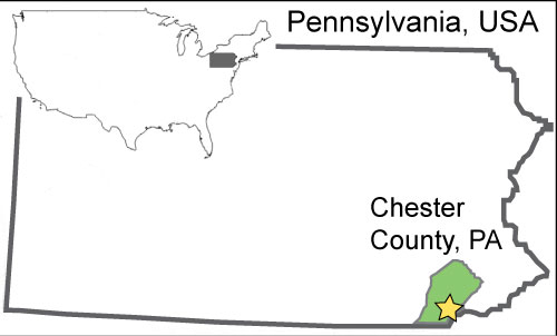
FIGURE 2. White Clay Creek leaf mat site, illustrating the contact (at trowel) between the darker hydric soil layer containing subfossil leaves and the overlying, lighter-colored legacy sediments. Stadia rod for scale.
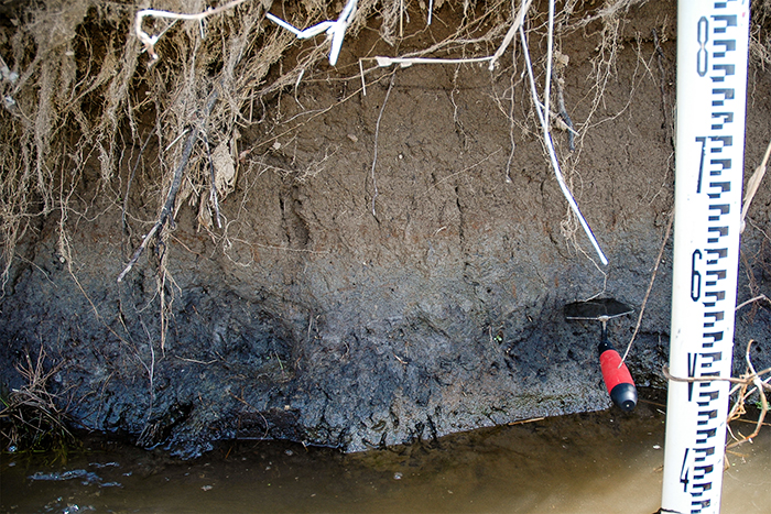
FIGURE 3. Alnus serrulata (Hazel Alder), EMS 425002. 1, Whole specimen; 2, Peltate scale and simple trichomes; 3, Stipitate gland trichome; 4, Detail of teeth; 5, Trichomes at vein junction; 6, Areolation with simple and branching freely ending veinlets.
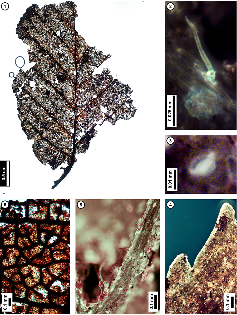
FIGURE 4. Fagus grandifolia (American Beech). 1, Leaf fragment, showing regularly spaced secondary veins, EMS 425004; 2, Detail of venation on EMS 425004; 3, Trichomes at vein junction, EMS 425004; 4, Trichomes at the vein junction of a modern F. grandifolia leaf from York County, Pennsylvania (collection Y1.2 of Wilf, 1997); 5, Rounded tooth on subfossil, EMS 425005; 6, Tooth and rounded sinus on modern F. grandifolia leaf from York County, Pennsylvania (collection Y1.2 of Wilf, 1997); 7, Trichome, EMS 425004.
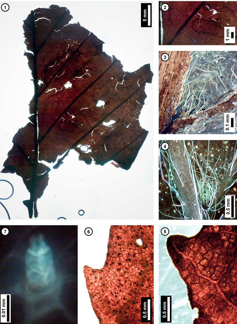
FIGURE 5. Quercus Section Lobatae (Red Oak group). 1, Leaf fragment showing asymmetrical lobe with acute apex, EMS 425011; 2, Abaxial leaf surface of EMS 425011, with randomly oriented stomata; 3, Simple trichome on leaf surface near secondary vein, EMS 425011. 4, Trichomes along a tertiary vein, EMS 425011; 5, Individual stoma of modern Q. rubra from York County, Pennsylvania (collection Y2.3 of Wilf, 1997) showing T-shape junction; 6, Individual stoma of EMS 425011.
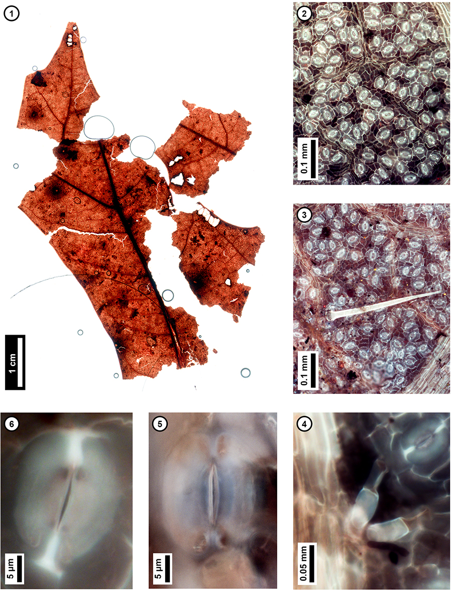
FIGURE 6. Quercus Section Quercus (White Oak group). 1, Lobe of modern Q. alba from York County Pennsylvania (collection of Wilf, 1997); 2, Subfossil, EMS 425008, showing entire margin with fimbrial vein and retuse, asymmetrical apex.
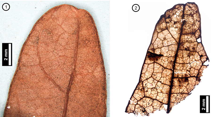
FIGURE 7. Liriodendron tulipifera (Tulip Tree). 1, Subfossil samara, EMS 425015; 2, Thickened ridge at basal attachment site of EMS 425015; 3, Mucronate samara tip from EMS 425014.
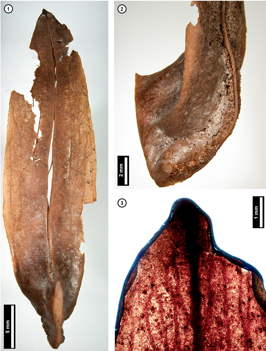
FIGURE 8. Three Salix spp. (Willow) subfossils. 1, EMS 425022; 2, EMS 425021; 3, EMS 425023; 4, Salicoid tooth, EMS 425021.
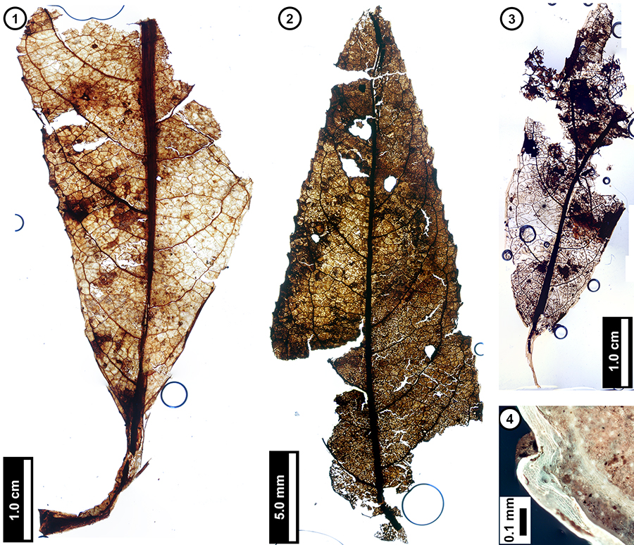
FIGURE 9. Acer negundo (Box Elder). 1, Leaflet, showing shallow lobes and rounded sinuses, EMS 425016; 2, Trichomes along veins, EMS 425016; 3, Trichomes along tooth margin, EMS 425016, with increased density on basal side of tooth; 4, Tooth of modern A. negundo from York County, Pennsylvania (collection Y2.2 of Wilf, 1997), showing the same general trichome pattern.
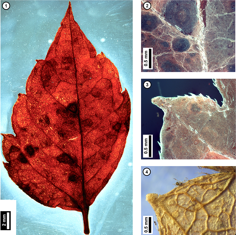
TABLE 1. Stratigraphy of the White Clay Creek site.
| Layer Number | Height (cm) |
Thickness (cm) | Plant Subfossils | Radiocarbon Dating Samples | Description |
| 9 | 110 - 117 | 7 | No | No | Modern soil and roots. No cross strata. |
| 8 | 103 - 110 | 7 | No | No | Fine to very fine sand layer directly below modern soil and roots. Overhangs stream bank. |
| 7 | 40 - 103 | 63 | No | No | Silt, light brown, finely laminated legacy sediment. No cross strata. |
| 6 | 37 - 40 | 3 | No | No | Silt and clay with occasional fine sand grains. Moderate brown when wet. No cross-strata. |
| 5 | 33 - 37 | 4 | No | No | Silt, dark yellow-brown when wet, dusky yellow when dry. No cross-strata. |
| 4 | 26 - 33 | 7 | No | No | Silt at base, coarsening upwards to fine sands at top. Dark yellow-brown when wet, dusky yellow when dry. Lightens in color upwards. Fine roots and occasional small stick fragments. No cross-strata. |
| 3 | 19 - 26 | 7 | Top of layer | UGAMS 07518 | Clay matrix with mica flecks, dusky brown when wet. Little to no plant debris, mainly fine roots with occasional leaf fragments and embedded sticks. No cross-strata. |
| 2 | 7 - 19 | 12 | Middle of layer | UGAMS 07517 | Clay matrix with mica flecks, dusky brown when wet. Less plant debris than layer below, and more fragmented when present. No cross-strata. |
| 1 | 0 - 7 | 7 | Bottom of layer | UGAMS 07516 | Pebbles and plant debris embedded in clay matrix, dusky brown when wet with mica flecks. Contains the majority of leaf subfossils. No cross-strata. |
TABLE 2. Radiocarbon results for leaf subfossils from White Clay Creek (Table 1). * Best-fit intercept age calibrated using CALIB REV7.1.0 Radiocarbon Calibration Program (Reimer et al., 2013). The “mean probability” ages for these units are 1774, 1562, and 1778 CE, for Base, Middle and Top samples, respectively. The selected calibrated 2σ intercepts of 282, 311, and 282 yr BP (before 1950) shown above, and chosen among several possible intercept ages, represent the dates that best fit the measured 14 C ages in combination with the stratigraphic order of the samples.
| Sample # | Name | 14 Age, Years BP, Uncalibrated Radiocarbon Age |
14C Age, Years BP, Calibrated 2σ* (Range = CE) |
| UGAMS 07518 | LMS Top | 200 ± 20 | 282 +/- 14 (1654-1682) |
| UGAMS 07517 | LMS Middle | 290 ± 25 | 311 +/- 22 (1617-1660) |
| UGAMS 07516 | LMS Base | 200 ± 25 | 282 +/- 16 (1652-1683) |
TABLE 3. Floristic comparison of the White Clay Creek, Big Spring Run, and Denlingers Mill sites.
| White Clay Creek (this paper) |
Big Spring Run (Voli et al., 2009) |
Denlingers Mill (Elliott et al., 2013) |
|
| Location | White Clay Creek, Chester County, PA | Big Spring Run, Lancaster County, PA | W. Branch Little Conestoga Ck., Lancaster County, PA |
| Material | Leaf and fruit macrofossils | Fruit and seed macrofossils | Leaf and fruit macrofossils |
| Age | 217 to 368 BP | 690 to 3,200 BP | 113 to 295 BP |
| Herbaceous species | None identified | Brasenia schreberi, Carex crinita, C. stipata, C. stricta, Eleocharis spp., Najas flexilis, Polygonum spp., Scirpus spp. | Present, but none identified |
| Woody species | Acer negundo, Alnus serrulata, Fagus grandifolia, Liriodendron tulipifera, Quercus Section Lobatae, Q. Section Quercus, Salix spp. | Juglans cinerea, Liriodendron tulipifera | Acer rubrum, A. spicatum, Betula lenta, Castanea dentata, Fagus grandifolia, Fraxinus nigra, Quercus Section Lobatae, Q. Section Quercus, Ostrya virginiana, Platanus occidentalis, Salix spp. |
 Sara J. Elliott. Department of Geosciences, Pennsylvania State University, University Park, PA 16802, USA; Bureau of Economic Geology, University of Texas, Austin, TX 78758, USA. sara.elliott@beg.utexas.edu (corresponding author)
Sara J. Elliott is a Research Scientist Associate II at the Bureau of Economic Geology, part of the Jackson School of Geosciences, University of Texas at Austin. She received her B.S. in Geosciences and Biology from the University of Miami in 2010, and her M.S. in Geosciences from Penn State University in 2012 working in P.Wilf's Paleobotany Lab. Previous research includes interpretation of Miocene mixed-marine clinoforms based on benthic Foraminifera paleoecology in the Dominican Republic, and identifying/reconstructing the pre-European settlement upslope old-growth forest communities in southeastern Pennsylvania using subfossil leaves. She currently specializes in SEM-Cathodoluminescence and runs the Fracture Research and Application Consortium's Zeiss SIGMA Field Emission Scanning Electron Microscope at the J.J. Pickle Research Campus in Austin. Current research includes bedding-parallel calcite veins in shales, diagenetic evolution of deformation bands in sandstones, pre- and postkinematic fracture cements in carbonate and siliciclastic rocks, and quartz vein textures in subduction zones. She was recently awarded a BEG Career-Development Publication Award grant for her work on coupled chemical-mechanical diagenetic processes in deformation bands of the southwestern USA.

 Christen L. Grettenberger. Department of Geosciences, Pennsylvania State University, University Park, PA 16802, USA. christygrettenberger@gmail.com
Christy Grettenberger (B.A., Western Washington University; M.S. and Ph.D. Pennsylvania State University) is an ecologist and biogeochemist. Her M.S. research at Penn State focused on the pre-European settlement flora in the Piedmont region. She also examined the role that microbial species can play in acid mine drainage remediation. She is currently a post-doctoral researcher at the University of California, Davis, where her research focuses on microbial communities in ice-covered Antarctic lakes as analogs for assemblages thriving during Neoproteozoic 'Snowball Earth' events.
 Michael P. Donovan. Department of Geosciences, Pennsylvania State University, University Park, PA 16802, USA. mpd187@psu.edu
Michael Donovan is a PhD student in the Geosciences Department at Penn State University interested in the evolution of plant-insect associations. He received a B.S. in Integrative Biology from University of Illinois in 2010, and a M.S. in Geosciences from Penn State University in 2013. His current research focuses on the recovery of herbivorous insects in Patagonia and the western USA after the Cretaceous-Paleogene extinction.
 Peter Wilf. Department of Geosciences, Pennsylvania State University, University Park, PA 16802, USA. pwilf@psu.edu
After an eclectic and non-geological undergrad career (B.A. Penn 1985), I spent three years teaching junior high school in New Jersey and then four years freelancing with my guitars in West Philly. I discovered geology and then paleobotany at the early age of 29 and have never looked back. I somehow moved from the street, almost literally, onto the doctoral track in Penn Geology and defended in 1998. Most of my thesis research was done in residence at the Smithsonian, on megafloral and paleoclimatic change across the Paleocene-Eocene boundary in southern Wyoming. During this time and in an ensuing Smithsonian postdoc, I began developing two major subsequent themes of my research: the fossil history of plant-insect associations and the unbelievable riches of Patagonian fossil floras. I spent three terrific years at Michigan, 1999-2002, as a Michigan Fellow and happily joined the Penn State Geosciences faculty in 2002, where I have been developing these and several other wonderful research projects with my students and colleagues all over the world.
 Robert C. Walter. Department of Earth and Environment, Franklin and Marshall College, Lancaster, PA 17604, USA. robert.walter@fandm.edu
Robert Walter (B.A., Franklin and Marshall College; Ph.D. Case Western Reserve University) is a geologist, geochemist and geochronologist. He has conducted field research in East Africa (human origins, sediment basin analyses, and volcanology), North America (Quaternary geology and environmental geology), and around the Pacific Rim (neotectonics). He was elected a Fellow of the California Academy of Science in 1989 and a Fellow of the Geological Society of America in 2011. He is a former American Association for the Advancement of Science (AAAS) Diplomacy Fellow to the U.S. Department of State, where he conducted research on complex humanitarian emergencies. Currently, he is an Associate Professor of Geosciences at Franklin and Marshall College, where his research has focused on water quality, soil-sediment-bedrock-water interactions, and human disturbances of these systems. In 2008, he and his colleague, Prof. Dorothy Merritts, were the recipients of Pennsylvania State Senate Resolution 283 for outstanding contributions to stream restoration and water quality improvements in the Chesapeake Bay Watershed. In 2011 he and Dorothy received the Kirk Bryan Award from the Geological Society of America for outstanding scholarship. In the 2011-2012 academic year he recieved the Allen B. Cox Visiting Distinguished Professorship at Stanford University. He directs the Big Spring Run Restoration Experiment (see http://www.bsr-project.org), is the author over 80 peer-reviewed publications, and co-wrote and co-directed five short documentary films on human evolution.
 Dorothy J. Merritts. Department of Earth and Environment, Franklin and Marshall College, Lancaster, PA 17604, USA. dorothy.merritts@fandm.edu
Dorothy Merritts (B.Sc. Indiana University of Pennsylvania; M.Sc. Stanford University, Ph.D. University of Arizona) is a geologist with expertise in Earth surface processes and landforms. Her current research in the United States is in the Appalachian region, where she is investigating the role of alternating Quaternary cold glacial/periglacial and warm climate conditions on landscape evolution. In addition, she examines how recent human activity has transformed valley bottom landscapes of Eastern North America since European settlement. She has been a professor in the Department of Earth and Environment at Franklin Marshall College in Lancaster, Pennsylvania since 1987. In 2004-2005 she was the Flora Stone Mather Visiting Distinguished Professor at Case Western Reserve University in Cleveland, Ohio. She was chair of the 2008-10 National Academy of Science Committee on Earth Surface Processes, served on the Steering Committee for the NSF National Center for Airborne Laser Mapping from 2008-11, and currently is chair of the National Academies/National Research Council Committee on Landscape Conservation Cooperatives. She was the co-recipient (with Robert Walter) of the 2011 Kirk Bryan Award for outstanding research from the Geological Society of America, and was the Allen Cox Visiting Professor at Stanford University in 2011-12. She is an author of two textbooks on environmental geosciences, author or co-author on more than 60 scientific articles, and the editor and contributing writer for numerous scientific books.
APPENDIX 1.
Historical background
Prior to European settlement, the North American landscape was already altered by Native American activities. Charcoal, isotope, and archeological evidence suggest that tribes along the East Coast used fire to clear forests long before European settlers arrived (Douglas, 1994; Springer et al., 2010). These activities created small but noticeable changes in the pollen record, including decreased contributions from forest taxa and increased representation from crop, disturbance, and early successional species (Baker et al., 1993; Black et al., 2006). Additionally, deposits in New Jersey and Pennsylvania indicate that Native American maize agriculture caused decreased forest cover and increased sedimentation in valley-bottoms between 1000 and 1600 C.E. (Stinchcomb et al., 2011). Therefore, floodplains were both hydrologically and ecologically altered by prehistoric peoples (Asch Sidell, 2008; Stinchcomb et al., 2011); however, the magnitude and impact of these alterations were significantly less than those caused by European settlers during the seventeenth and eighteenth centuries.
European settlement significantly affected the hydrogeomorphology and associated wetland and riparian flora throughout the Piedmont region due, in large part, to the mills, forges, furnaces, and mining operations settlers built to support their communities (Walter and Merritts, 2008; Voli et al., 2009; Wegmann et al., 2012). These structures were dependent on hydropower provided by tens of thousands of dams erected on streams throughout the region (Walter and Merritts, 2008; Merritts et al., 2013). In addition to this expansive infrastructure, European colonists transformed hundreds of thousands of acres of upland, old-growth forest into agricultural fields in the northeastern United States (Costa, 1975; Thompson et al., 2013). Many of the crops planted, such as tobacco, were harmful to soil quality, so settlers frequently cleared more land as fields were exhausted and abandoned after a few seasons (Gottschalk, 1945; Middleton, 1953).
These agricultural clearing and tilling practices triggered large-scale topsoil erosion throughout the Piedmont region (Costa, 1975; James, 2013; Merritts et al., 2013). The fine-grained, extremely mobile, phosphorus and nitrogen-rich silts deposited in valley-bottoms and floodplains from colonial activities are collectively referred to as “legacy sediments” (Walter and Merritts, 2008; James, 2013).
Dams built across the valley-bottoms decreased flow velocity by up to 60%, causing the legacy sediments to settle out of the water column and to form alluvial deposits behind milldams that could stretch hundreds of meters, often upstream to the next dam (Walter and Merritts, 2008; Merritts et al., 2010b; Merritts et al., 2013). In the Pennsylvania Piedmont, two-thirds of this sediment was eventually deposited on modified floodplains and on lower hill slopes within river valleys, causing several meters of floodplain elevation relative to hydrologic base level along the entire lengths of streams and across the entire widths of valley floors (Walter and Merritts, 2008; Hartranft et al., 2011; James, 2013; Wegmann et al., 2013; Weitzman et al., 2014).
As alternative energy sources became available, dams were either removed or abandoned and eventually breached (Merritts et al., 2013). These events triggered stream incision through the reservoir sediments, ultimately forming meandering streams with elevated banks and characteristic water flow patterns involving fast-flowing riffles with artificially steep gradients at dam sites, and pools where ponds had formed behind the milldams (Simon, 1989; Walter and Merritts, 2008; Merritts et al., 2010b). This process was repeated tens of thousands of times across the landscape, dramatically shifting the hydrogeomorphology of first to third order streams from small, vegetated, anabranching channels that were well-connected with the water table and their floodplains to the single-channel, steep-banked streams seen today (Simon, 1989; Walter and Merritts, 2008; Voli et al., 2009; Hartranft et al., 2011).
APPENDIX 2.
Environmental restoration
Increasingly accurate models of the regional pre-settlement wetland and riparian zone flora, especially including trees, are critical for guiding restoration and conservation decisions to ensure a resulting, functioning ecosystem (Weisberg et al., 2013; Johnson, 2014; Smucker and Detenbeck, 2014). Communities assembled from Holocene floral reconstructions can be carefully used as baseline targets for restoration and conservation projects in areas influenced by human activities (Palmer et al., 2005; Bennion et al., 2011).
Post-milldam streams with pools, riffles, and point bars (Walter and Merritts, 2008) were once considered “natural”, and they were commonly used as models for environmental restoration projects. However, the experimental “restorations” continued to modify riparian zone vegetation and prevent streams from breaching onto their floodplains (FISRWG, 2008), resulting in limited overall success (Gutshall and Oberholtzer, 2011; Hartranft et al., 2011). Recently, it has been demonstrated that a more sustainable approach is to completely remove legacy sediments, then restore the naturally occurring riparian vegetation at the original base level wherever possible (Voli et al., 2009; Gutshall and Oberholtzer 2011; Hartranft et al., 2011; Niemitz et al., 2013). Rapid planting of native flora, including hardwood trees, following legacy sediment removal is necessary because weedy species are more likely to colonize the disturbed environment first, excluding the native riparian vegetation and decreasing ecosystem function and riparian zone restoration success (Shafroth et al., 2002; Stanley and Doyle, 2003; Doyle et al., 2005; Gutshall and Oberholtzer, 2011; Kaase and Katz, 2012). More than three decades may be needed for hardwood species to recolonize an altered area after dam removal (Stephens, 2014; Kim et al., 2015), and vegetation along the riparian zone is one of the most important drivers of restoration success (FISRWG, 2008; Gutshall and Oberholtzer, 2011).
Successful restoration, including reestablishing a stream’s access to its floodplain, reducing erosion, and creating a self-sustaining wetland and riparian zone, necessitates an understanding of the pre-European settlement floral community. After removal of legacy sediments, future restoration efforts that plant documented prehistoric wetland and lowland species, including those described in this study, may be able to recreate native and ecologically functional riparian and valley-margin forests that closely mimic the unaltered environment. Additionally, restoration projects that include legacy sediment removal and the re-establishment of native species in the riparian zone can decrease the amount of sediment eroded and transported to downstream areas like the Chesapeake Bay (Correll et al., 1992; Walter et al., 2007; Gutshall and Oberholtzer, 2011).
APPENDIX 3.
Advantages of subfossil leaves
Most Holocene floral reconstructions are based on fossil pollen because it is often abundant and well preserved (Gajewski, 1988; Dull, 1999). However, pollen is susceptible to temporal and spatial averaging, and it is frequently only identifiable to the genus level (Birks and Birks, 2000). Fruits, seeds, and woods are also regularly used, but they are likewise prone to temporal and spatial averaging and are frequently not identifiable to the species level. On the other hand, Holocene leaves are usually identifiable to the species level and represent the most temporally and spatially localized information because they cannot be reworked. However, leaf subfossils are not often used because they are fragile, difficult to process, and quite rare in comparison to more durable fruits, seeds, woods, and palynomorphs (Goetcheus and Birks, 2001). Fruit, seed, and pollen assemblages are generally considered to have temporal resolutions of ![]() years because they are highly resistant to decomposition and abrasion and are therefore prone to reworking, redeposition, and temporal averaging (Behrensmeyer et al., 2000; Greenwood, 1991). In contrast, leaf floras are considered to have higher temporal resolution, generally between
years because they are highly resistant to decomposition and abrasion and are therefore prone to reworking, redeposition, and temporal averaging (Behrensmeyer et al., 2000; Greenwood, 1991). In contrast, leaf floras are considered to have higher temporal resolution, generally between ![]() years (Behrensmeyer et al., 2000; Birks and Birks, 2000). Additionally, leaf macrofossils frequently represent a more local community than either fossil pollen or seeds because they are transported shorter distances (Wing and DiMichele, 1995; Davies-Vollum and Wing, 1998; Behrensmeyer et al., 2000; Birks and Birks, 2000). When combined with published paleontological data from seeds and pollen, community reconstructions based on leaf macrofossils can overcome many of the spatial and temporal disadvantages associated with pollen and seeds alone, providing a more accurate view of ancient communities (Birks and Birks, 2000).
years (Behrensmeyer et al., 2000; Birks and Birks, 2000). Additionally, leaf macrofossils frequently represent a more local community than either fossil pollen or seeds because they are transported shorter distances (Wing and DiMichele, 1995; Davies-Vollum and Wing, 1998; Behrensmeyer et al., 2000; Birks and Birks, 2000). When combined with published paleontological data from seeds and pollen, community reconstructions based on leaf macrofossils can overcome many of the spatial and temporal disadvantages associated with pollen and seeds alone, providing a more accurate view of ancient communities (Birks and Birks, 2000).
APPENDIX 4.
White Clay Creek specimen data
Riparian and valley-margin hardwood species of pre-colonial Piedmont forests: A preliminary study of subfossil leaves from White Clay Creek, southeastern Pennsylvania, USA
Plain Language Abstract
Native Americans inhabited eastern North America for millennia, but their environmental impacts were negligible compared with those of European settlers. A significant example is the tens of thousands of milldams that the colonists constructed across Piedmont streams to power their furnaces, forges, and mills during the late 17th to 19th centuries. These activities, combined with intense upland deforestation, led to soil erosion and mobilization of unprecedented amounts of nutrient-rich silt downstream and onto "floodplains", i.e., sediment-filled terraces. These activities effectively raised the "floodplain," in some places by up to 5 meters, causing an unnaturally large gap between the land surface and the underlying water table. These effects sharply reduced populations of native riparian trees and other plants, dramatically transforming entire ecosystems along with the hydrology. Our study focuses on direct, paleobotanical evidence for changes in riparian and lower-slope vegetation brought about by the landscape modifications of early European settlers, and it adds to the emerging picture of pre-settlement Piedmont landscapes.
Along White Clay Creek in Chester County, southeastern Pennsylvania, we recovered and identified pre-European settlement subfossil leaves (leaves not yet lithified) from an ancient wetland soil that is now buried beneath more than a meter of upland silts that were trapped in the valley-bottom as a result of milldam ponding. The collected samples are constrained to pre-European settlement (1639 - 1668 C.E) through radiocarbon dating of selected leaf specimens from the fossil deposit. From these samples, we identified some of the hardwood tree species that dominated the riparian and valley-margin areas of Piedmont streams before extensive deforestation, agriculture, and human infrastructure modified the environment. Subfossil leaves are rarely used by paleontologists because of their extreme fragility, but because they are minimally transported and temporally mixed compared to more commonly studied seeds and pollen, they can provide detailed, localized views of past landscapes that are not usually available otherwise.
Based on our discoveries and comparisons to previously published data from nearby sites in southeastern Pennsylvania, we conclude that the hardwood riparian zone vegetation of White Clay Creek once contained willows, Hazel Alder, and Box Elder, while the surrounding lower hill slopes supported red and white oaks, Tulip Tree, and American Beech. The pre-settlement forests could have been similar to a modern day Red Maple-Black Ash swamp forest in wetlands and on floodplains, and a Mesic Oak-Beech mixed forest on lower hill slopes. Compared with the modern vegetation at the site, which is mostly low-statured and weedy, it is apparent that extreme modifications of the floodplains and their vegetation have occurred during the last few centuries.
Resumen en Español
Especies de frondosas de ribera y de márgenes de valle de bosques pre-coloniales de Piedmont: Un estudio preliminar de hojas subfósiles de White Clay Creek, sureste de Pennsylvania, EE.UU.
A partir del siglo XVII, las actividades coloniales como el desmonte de tierras, la agricultura y el represado alteraron significativamente los paisajes, la vegetación y la hidrogeomorfología de la región noreste de Piedmont, actualmente EE.UU. En la actualidad, la maleza y la vegetación no nativa dominan las zonas de ribera alteradas y las laderas de las colinas, donde una vez prevalecieron los bosques maduros de madera dura. Varios estudios han identificado las floras originales de herbáceas de humedales a partir de restos de frutas y semillas. Sin embargo, sólo un estudio ha proporcionado evidencia sobre las especies leñosas originales que eran dominantes mediante el uso de la señal localizada disponible de hojas subfósiles; dicho estudio reconstruyó los bosques de arce-fresno de llanura de inundación de pantano a lo largo de los márgenes de valle y los bosques mixtos roble-haya en las laderas elevadas a partir de la asociación hallada en un yacimiento del condado de Lancaster, sudeste de Pennsylvania. Aquí, se estudian las hojas subfósiles que han sido recuperadas de los suelos enterrados de los humedales de White Clay Creek en el vecino condado de Chester, Pennsylvania, de forma que se proporcionan nuevos datos espaciales de relevancia para conocer los bosques maduros regionales. La asociación subfósil de hojas, fechada con radiocarbono aproximadamente en el año 1650, se compone de especies leñosas con una diversa gama de afinidades por los humedales, lo que indica que se originó por aportes tanto de la zona de ribera como de las laderas elevadas más bajas de los alrededores. Las especies de humedales, tanto facultativas como no facultativas, incluyen el sauce (Salix spp.) y el aliso de la especie Alnus serrulata. El negundo hallado (Acer negundo) es la única especie facultativa presente, mientras que el haya americana (Fagus grandifolia), los grupos de roble "blanco" y rojo (Quercus Section Quercus y Q. Section Lobatae, respectivamente), y el tulípero de Virginia (Liriodendron tulipifera) comprenden los taxones facultativos de tierras altas que han sido identificados. Estos resultados complementan y corroboran el trabajo previo y elevan la fiabilidad de nuestra comprensión del paisaje pre-europeo, lo que podría hacer aumentar la eficacia de los proyectos regionales de restauración ambiental.
Palabras clave: paleobotánica; Holoceno; hojas; paleoecología; restauración; presas
Traducción: Enrique Peñalver (Sociedad Española de Paleontología)
Résumé en Français
Les espèces ligneuses des zones ripariennes et des bords de vallées dans les forêts précoloniales du Piedmont : une étude préliminaire des feuilles subfossiles de la « White Clay Creek », sud-est de la Pennsylvanie, États-Unis
Au début du XVIIème siècle, les activités coloniales telles que le défrichement, l'agriculture, et la construction d'écluses de moulins ont transformé de manière importante les paysages, la végétation, et l'hydrogéomorphologie de la région du nord-est du Piedmont, aux États-Unis. Actuellement, une végétation allochtone de mauvaises herbes domine les paysages ainsi transformés des zones ripariennes et des pentes de collines où prédominaient autrefois les forêts ligneuses primaires. D'après des fruits et des graines, plusieurs études ont identifié des flores herbacées de terrains humides antérieures à la colonisation. Cependant, seule une étude a fourni des preuves de la domination des espèces ligneuses avant la colonisation en utilisant le signal local disponible d'après les feuilles subfossiles : ce travail a reconstitué des forêts de marécages de plaines d'inondation à érables negundo le long des bords de vallées et des forêts mixtes sur la partie supérieure des pentes d'un site dans le Comté de Lancaster, au sud de la Pennsylvanie. Dans cet article, nous examinons les feuilles subfossiles provenant des sols enfouis des zones humides de la « White Clay Creek » dans le Comté voisin de Chester, Pennsylvanie, fournissant une quantité importante de nouvelles données spatiales pour notre compréhension des forêts primaires régionales. L'assemblage de feuilles, daté aux alentours de 1650 par radiocarbone, est composé d'espèces ligneuses avec une gamme variée d'affinités avec les terrains humides, indiquant des sources à la fois dans la zone riparienne et dans les pentes des basses collines avoisinantes. Les espèces obligées et facultatives de zones humides incluent le saule (Salix spp.) et l'aulne tendre (Alnus serrulata). L'érable negundo (Acer negundo) est la seule espèce facultative présente, alors que le hêtre à grandes feuilles (Fagus grandifolia), les groupes des chênes blancs et rouges (respectivement Quercus Section Quercus et Q. Section Lobatae), et le tulipier de Virginie (Liriodendron tulipifera) constituent les taxons facultatifs des hautes terres identifiés. Ces résultats complètent et corroborent les travaux précédents, permettant une plus grande confiance dans la compréhension des paysages antérieurs à la colonisation par les Européens, et augmentant ainsi potentiellement l'efficacité des projets régionaux de restauration environnementale.
Mots-clés : paléobotanique ; Holocène ; feuilles ; paléoécologie ; restauration ; écluses de moulin
Translator: Antoine Souron
Deutsche Zusammenfassung
Ufernahe und Talrand-bewohnende Hartholz-Arten prä-kolonialer Piedmont Wälder: eine Vorstudie über subfossile Blätter aus dem White Clay Creek, südöstliches Pennsylvania, USA
Ab dem 17. Jahrhundert veränderten Kolonialaktivitäten wie Rodungen, Landwirtschaft und Mühlenwehre die Landschaft, die Vegetation und die Hydrogeomorphologie der nordöstlichen Piedmont-Region (moderne USA) signifikant. Heute dominiert eine verunkrautete und nicht-einheimische Vegetation die veränderte Uferzone und Berghänge, wo einst altbestehende Hartholz-Wälder vorherrschten. Verschiedene Untersuchungen haben anhand von Früchten und Samen krautartige Feuchtgebiets-Floren aus der Zeit vor der Besiedelung identifiziert. Jedoch nur ein Bericht hat den Nachweis der dominierenden Holzart aus der Vor-Besiedelungszeit erbracht, indem das eingegrenzte Merkmal subfossiler Blätter verwendet wurde. Diese Arbeit rekonstruierte Ahorn-Eschen Sumpfauenwälder entlang Talrändern und Eichen-Buchen-Mischwälder auf oberen Hängen an einem Standort in Lancaster County, südöstliches Pennsylvania. Hier untersuchen wir subfossile Blätter aus den verschütteten Sümpfen von White Clay Creek im benachbarten Chester County, Pennsylvania, die signifikante neue räumliche Daten zum Verständnis der regionalen altbestehenden Wälder liefern. Die Blatt-Assemblage, C-14 datiert auf ca. 1650, besteht aus Holzarten mit einem breiten Spektrum von Feuchtgebietsaffinitäten und weist auf Quellen sowohl in der Uferzone als auch in den unteren Berghängen hin. Obligate und fakultative Feuchtgebiets-Arten beinhalten Weide (Salix spp.) und Hasel-Erle (Alnus serrulata). Eschen-Ahorn (Acer negundo) ist die einzige fakultative Art, während die Ameriknische Buche (Fagus grandifolia), die Weiss-und Roteichen-Gruppen (Quercus Sektion Quercus und Q. Sektion Lobatae) und der Tulpenbaum (Liriodendron tulipifera) die identifizierten fakultativ-Hochland Taxa umfassen. Diese Ergebnisse ergänzen und bestätigen vorangehende Arbeiten, ermöglichen ein besseres Verständnis der vor-europäischen Landschaft und erhöhen potentiell die Effektivität regionaler Umweltsanierungs-Projekte.
Schlüsselwörter: Paläobotanik; Holozän; Blätter; Paläoökologie; Restoration; Mühlenwehre
Translator: Eva Gebauer
Arabic

Translator: Ashraf M.T. Elewa
-
-
PE: An influential journal
 Palaeontologia Electronica among the most influential palaeontological journals
Article number: 27.2.2E
July 2024

 A Review of Handbook of Paleoichthyology Volume 8a: Actinopterygii I, Palaeoniscimorpha, Stem Neopterygii, Chondrostei